Difference between revisions of "Hind"
(Created page with "<div id="content_view" class="wiki" style="display: block"> =Hind= {| class="wiki_table" | Lat: 7.9°S, Long: 7.4°E, Diam: 29 km, Depth: 2.98 km, [http://the-moon.wikispa...") |
|||
| Line 3: | Line 3: | ||
{| class="wiki_table" | {| class="wiki_table" | ||
| | | | ||
| − | Lat: 7.9°S, Long: 7.4°E, Diam: 29 km, Depth: 2.98 km, [http://the-moon. | + | Lat: 7.9°S, Long: 7.4°E, Diam: 29 km, Depth: 2.98 km, [http://the-moon.us/wiki/R%C3%BCkl%2045 Rükl: 45]<br /> |
|} | |} | ||
<div id="toc"> | <div id="toc"> | ||
| Line 11: | Line 11: | ||
[http://www.lpod.org/coppermine/thumbnails.php?album=search&type=full&search=Hind LPOD Photo Gallery] [http://www.lpi.usra.edu/resources/lunar_orbiter/bin/srch_nam.shtml?Hind%7C0 Lunar Orbiter Images] [http://www.lpi.usra.edu/resources/apollo/search/feature/?feature=Hind Apollo Images]<br /> Plus two "forgotten" Hasselblads of Hind: [http://www.lpi.usra.edu/resources/apollo/frame/?AS12-50-7429 AS12-50-7429] and [http://www.lpi.usra.edu/resources/apollo/frame/?AS12-50-7430 AS12-50-7430].<br /> Additional research: Danny Caes<br /> <br /> | [http://www.lpod.org/coppermine/thumbnails.php?album=search&type=full&search=Hind LPOD Photo Gallery] [http://www.lpi.usra.edu/resources/lunar_orbiter/bin/srch_nam.shtml?Hind%7C0 Lunar Orbiter Images] [http://www.lpi.usra.edu/resources/apollo/search/feature/?feature=Hind Apollo Images]<br /> Plus two "forgotten" Hasselblads of Hind: [http://www.lpi.usra.edu/resources/apollo/frame/?AS12-50-7429 AS12-50-7429] and [http://www.lpi.usra.edu/resources/apollo/frame/?AS12-50-7430 AS12-50-7430].<br /> Additional research: Danny Caes<br /> <br /> | ||
==Maps== | ==Maps== | ||
| − | ''([http://the-moon. | + | ''([http://the-moon.us/wiki/LAC%20zone LAC zone] 77B3)'' [http://www.lpi.usra.edu/resources/mapcatalog/LAC/lac77/ LAC map] [http://www.lpi.usra.edu/resources/mapcatalog/usgs/I566/ Geologic map] [http://www.lpi.usra.edu/resources/mapcatalog/LM/lm77/ LM map] [http://www.lpi.usra.edu/resources/mapcatalog/AIC/AIC77B/ AIC map] [http://www.lpi.usra.edu/resources/mapcatalog/LTO/lto77b3_1/ LTO map]<br /> <br /> |
==Description== | ==Description== | ||
<br /> | <br /> | ||
==Description: Elger== | ==Description: Elger== | ||
| − | ''([http://the-moon. | + | ''([http://the-moon.us/wiki/IAU%20Directions IAU Directions])'' HIND.--A ring-plain, 16 miles in diameter, a few miles E. of [http://the-moon.us/wiki/Halley Halley], with a peak on its W. wall 10,000 feet above the floor. The border is broken both on the S.W. and N.W. by small craters.<br /> <br /> [[http://the-moon.us/wiki/Horrocks Horrocks], [http://the-moon.us/wiki/Halley Halley], and Hind may be regarded as strictly belonging to [http://the-moon.us/wiki/Hipparchus Hipparchus].]<br /> <br /> |
==Description: Wikipedia== | ==Description: Wikipedia== | ||
[http://en.wikipedia.org/wiki/Hind_%28crater%29 Hind]<br /> <br /> | [http://en.wikipedia.org/wiki/Hind_%28crater%29 Hind]<br /> <br /> | ||
==Additional Information== | ==Additional Information== | ||
| − | Depth data from [http://the-moon. | + | Depth data from [http://the-moon.us/wiki/Kurt%20Fisher%20crater%20depths Kurt Fisher database]<br /> |
* Arthur, 1974: 2.98 km | * Arthur, 1974: 2.98 km | ||
* Westfall, 2000: 2.98 km | * Westfall, 2000: 2.98 km | ||
| Line 25: | Line 25: | ||
* Cherrington, 1969: 2.8 km | * Cherrington, 1969: 2.8 km | ||
| − | * Hind and its satellite crater C are on the [http://the-moon. | + | * Hind and its satellite crater C are on the [http://the-moon.us/wiki/ALPO%20list%20of%20bright%20ray%20craters ALPO list of bright ray craters] |
<br /> | <br /> | ||
=='''A unique photograph'''== | =='''A unique photograph'''== | ||
Revision as of 19:16, 11 April 2018
Contents
Hind
|
Lat: 7.9°S, Long: 7.4°E, Diam: 29 km, Depth: 2.98 km, Rükl: 45 |
Table of Contents

Apollo 16 M572
Images
LPOD Photo Gallery Lunar Orbiter Images Apollo Images
Plus two "forgotten" Hasselblads of Hind: AS12-50-7429 and AS12-50-7430.
Additional research: Danny Caes
Maps
(LAC zone 77B3) LAC map Geologic map LM map AIC map LTO map
Description
Description: Elger
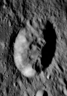
(IAU Directions) HIND.--A ring-plain, 16 miles in diameter, a few miles E. of Halley, with a peak on its W. wall 10,000 feet above the floor. The border is broken both on the S.W. and N.W. by small craters.
[Horrocks, Halley, and Hind may be regarded as strictly belonging to Hipparchus.]
Description: Wikipedia
Additional Information
Depth data from Kurt Fisher database
- Arthur, 1974: 2.98 km
- Westfall, 2000: 2.98 km
- Viscardy, 1985: 2.98 km
- Cherrington, 1969: 2.8 km
- Hind and its satellite crater C are on the ALPO list of bright ray craters
A unique photograph
AS12-51-7501 is "not just another" orbital Hasselblad photograph of crater Hind (in the upper right corner of this low-res LPI version). Although it was made through one of the small windows of Apollo 12's CSM Yankee Clipper, the most remarkable fact about this photograph is: it is the only Apollo-Hasselblad which shows the Lunar Module (L.M. Intrepid) surrounded by lunar background, instead of black space!
A medium-resolution version of this photograph shows LM Intrepid "below" the lunar horizon. There's also a King-Size Hi-Res version of this photograph, online in Kipp Teague's PROJECT APOLLO ARCHIVE.
Additional research: Danny Caes
Nomenclature
- John Russell Hind (May 12, 1823–December 23, 1895) was a British astronomer. He is notable for being one of the early discoverers of asteroids. He also discovered and observed the variable stars and discovered Nova Ophiuchi 1848 (V841 Ophiuchi), the first nova of modern times (since the supernova SN 1604).
  - It's a bit strange to think that the name of this crater (W.R.Birt's Hind) could have been M.F.Van Langren's Trautmansdorffii, according to page 200 of Ewen A. Whitaker's Mapping and Naming the Moon (1999).- DannyCaes DannyCaes May 27, 2013
LPOD Articles
Bibliography
Crater Hind: APOLLO OVER THE MOON; A VIEW FROM ORBIT, Chapter 3: The Terrae (Part 2), Figure 49.
John Russell Hind in the Sourcebook Project:
- Historical Sun-Darkenings (Nature, 1879) (Dark Days), see: Tornados, Dark Days, Anomalous Precipitation, and related weather phenomena (William R. Corliss, The Sourcebook Project, 1983).
Vulcan: the lost intramercurial planet
- The Intra-Mercurial Planet or Planets (Nature, 1876), see: Mysterious Universe, a handbook of astronomical anomalies (William R. Corliss, The Sourcebook Project, 1979).
- Stellar Objects seen during the Eclipse of 1869 (Nature, 1878), see: Mysterious Universe, a handbook of astronomical anomalies (William R. Corliss, The Sourcebook Project, 1979).
This page has been edited 1 times. The last modification was made by - tychocrater tychocrater on Jun 13, 2009 3:24 pm - afx3u2