Difference between revisions of "Van de Graaff"
| Line 14: | Line 14: | ||
==Images== | ==Images== | ||
[http://www.lpi.usra.edu/resources/lunarorbiter/frame/?2033 LO2 - Frame No. 2033] from the [http://www.lpi.usra.edu/resources/lunarorbiter/mission/?2 Lunar & Planetary Institute].<br /> [http://www.lpod.org/coppermine/thumbnails.php?album=search&type=full&search=Van%20de%20Graaff LPOD Photo Gallery] [http://www.lpi.usra.edu/resources/lunar_orbiter/bin/srch_nam.shtml?Van%20de%20Graaff%7C0 Lunar Orbiter Images] [http://www.lpi.usra.edu/resources/apollo/search/feature/?feature=Van%20de%20Graaff Apollo Images]<br /> | [http://www.lpi.usra.edu/resources/lunarorbiter/frame/?2033 LO2 - Frame No. 2033] from the [http://www.lpi.usra.edu/resources/lunarorbiter/mission/?2 Lunar & Planetary Institute].<br /> [http://www.lpod.org/coppermine/thumbnails.php?album=search&type=full&search=Van%20de%20Graaff LPOD Photo Gallery] [http://www.lpi.usra.edu/resources/lunar_orbiter/bin/srch_nam.shtml?Van%20de%20Graaff%7C0 Lunar Orbiter Images] [http://www.lpi.usra.edu/resources/apollo/search/feature/?feature=Van%20de%20Graaff Apollo Images]<br /> | ||
| − | * ''Note:'' '''Van de Graaff''' can be found in Lunar Orbiter LACs 103 and 104 of the [[USGS%20Digital%20Atlas|USGS Digital Atlas]], however, as these LACs were under construction, or showed only a shaded-relief image at time of writing (30 June 2009), updates should be checked for.<span class="membersnap">- | + | * ''Note:'' '''Van de Graaff''' can be found in Lunar Orbiter LACs 103 and 104 of the [[USGS%20Digital%20Atlas|USGS Digital Atlas]], however, as these LACs were under construction, or showed only a shaded-relief image at time of writing (30 June 2009), updates should be checked for.<span class="membersnap">- JohnMoore2</span> |
<br /> | <br /> | ||
==Maps== | ==Maps== | ||
''([[LAC%20zone|LAC zone]] 104D1)'' [http://www.lpi.usra.edu/resources/mapcatalog/LM/lm104/ LM map]<br /> <br /> | ''([[LAC%20zone|LAC zone]] 104D1)'' [http://www.lpi.usra.edu/resources/mapcatalog/LM/lm104/ LM map]<br /> <br /> | ||
==Description== | ==Description== | ||
| − | To all intents and purposes, '''Van de Graaff''', at first view looks like a giant peanut. Lying on the north-western region of the [[South%20Pole-Aitken%20Basin|South Pole Aitken Basin (SPA-B)]] -- a 2500 kilometre-wide basin of the [[Stratigraphy|pre-Nectarian]] period (~ 4.6 to 3.92 bn years), the feature is actually the result of two craters that have merged together as one. The supposed reason for their appearance may thus be that they were caused by two impactors arriving simultaneously onto the lunar surface. As a result, ejecta from each impact which would have formed rims in the central regions of '''Van de Graaff''' have been obliterated; leaving behind no rims here at all. Both merged craters were created during the same period as SPA-B above, so those rims that do remain are worn or eroded-looking. The interior walls show a groove-like structure to them which may be the result of ejecta from both impacts, however, there is another suggestion that the grooveswere caused by seismic activity with an antipode <br /> slant to it -- see the Wikipedia explanation below. '''Van de Graaff's''' floor is covered in hundreds of small craters, but outstanding to these is the several other larger crates which range from 15 to 30 kilometres across that run down its length. Additionally so, two things of note to '''Van de Graaff's''' floor-region would be: Firstly, that while the south-western portion does have a main central peak to speak of, the north-eastern portion doesn't seem to have any at all worth talking about. Secondly, as the more northerly crater of '''Van de Graaff''' shows a more darkish-looking material (possibly of mare) in its north-east, is this any indication as to the direction in which the impactor(s) initiallly came from?<span class="membersnap">- | + | To all intents and purposes, '''Van de Graaff''', at first view looks like a giant peanut. Lying on the north-western region of the [[South%20Pole-Aitken%20Basin|South Pole Aitken Basin (SPA-B)]] -- a 2500 kilometre-wide basin of the [[Stratigraphy|pre-Nectarian]] period (~ 4.6 to 3.92 bn years), the feature is actually the result of two craters that have merged together as one. The supposed reason for their appearance may thus be that they were caused by two impactors arriving simultaneously onto the lunar surface. As a result, ejecta from each impact which would have formed rims in the central regions of '''Van de Graaff''' have been obliterated; leaving behind no rims here at all. Both merged craters were created during the same period as SPA-B above, so those rims that do remain are worn or eroded-looking. The interior walls show a groove-like structure to them which may be the result of ejecta from both impacts, however, there is another suggestion that the grooveswere caused by seismic activity with an antipode <br /> slant to it -- see the Wikipedia explanation below. '''Van de Graaff's''' floor is covered in hundreds of small craters, but outstanding to these is the several other larger crates which range from 15 to 30 kilometres across that run down its length. Additionally so, two things of note to '''Van de Graaff's''' floor-region would be: Firstly, that while the south-western portion does have a main central peak to speak of, the north-eastern portion doesn't seem to have any at all worth talking about. Secondly, as the more northerly crater of '''Van de Graaff''' shows a more darkish-looking material (possibly of mare) in its north-east, is this any indication as to the direction in which the impactor(s) initiallly came from?<span class="membersnap">- JohnMoore2</span><br /> <br /> |
===Wikipedia=== | ===Wikipedia=== | ||
[http://en.wikipedia.org/wiki/Van_de_Graaff_(crater) Van de Graaff]<br /> <br /> | [http://en.wikipedia.org/wiki/Van_de_Graaff_(crater) Van de Graaff]<br /> <br /> | ||
Latest revision as of 20:43, 16 April 2018
Contents
Van de Graaff
|
Lat: 27.59°S, Long: 171.92°E, Diam: 245.51 km, Depth: km, Rükl: (farside), Nectarian | |
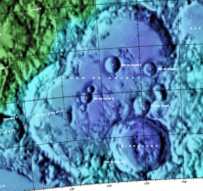
Right: Combined image of Color-coded LAC 103 and LAC 104 from the USGS Digital Atlas(see Note in 'Images' section below).
Images
LO2 - Frame No. 2033 from the Lunar & Planetary Institute.
LPOD Photo Gallery Lunar Orbiter Images Apollo Images
- Note: Van de Graaff can be found in Lunar Orbiter LACs 103 and 104 of the USGS Digital Atlas, however, as these LACs were under construction, or showed only a shaded-relief image at time of writing (30 June 2009), updates should be checked for.- JohnMoore2
Maps
Description
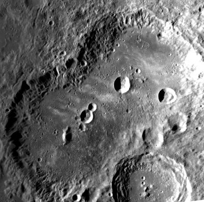
To all intents and purposes, Van de Graaff, at first view looks like a giant peanut. Lying on the north-western region of the South Pole Aitken Basin (SPA-B) -- a 2500 kilometre-wide basin of the pre-Nectarian period (~ 4.6 to 3.92 bn years), the feature is actually the result of two craters that have merged together as one. The supposed reason for their appearance may thus be that they were caused by two impactors arriving simultaneously onto the lunar surface. As a result, ejecta from each impact which would have formed rims in the central regions of Van de Graaff have been obliterated; leaving behind no rims here at all. Both merged craters were created during the same period as SPA-B above, so those rims that do remain are worn or eroded-looking. The interior walls show a groove-like structure to them which may be the result of ejecta from both impacts, however, there is another suggestion that the grooveswere caused by seismic activity with an antipode
  slant to it -- see the Wikipedia explanation below. Van de Graaff's floor is covered in hundreds of small craters, but outstanding to these is the several other larger crates which range from 15 to 30 kilometres across that run down its length. Additionally so, two things of note to Van de Graaff's floor-region would be: Firstly, that while the south-western portion does have a main central peak to speak of, the north-eastern portion doesn't seem to have any at all worth talking about. Secondly, as the more northerly crater of Van de Graaff shows a more darkish-looking material (possibly of mare) in its north-east, is this any indication as to the direction in which the impactor(s) initiallly came from?- JohnMoore2
Wikipedia
Additional Information
- IAU page: Van de Graaff
- A major swirl of 10,000 km^2 stretches across Van de Graff and Mare Ingenii (Hughes and others, 2006)
- Van de Graaff was selected as a Tier 2 Constellation Program Region of Interest.
Nomenclature
- Named for Robert Jemison Van de Graaff (December 20, 1901 - January 16, 1967), an American physicist, instrument maker and professor of physics at Princeton University. Van de Graaff was the designer of the Van de Graaff generator, a device which produces High voltages. In 1929, Van de Graaff developed his first generator with help from Nicholas Burke (producing 80,000 volts); by 1933, he had constructed a much larger generator, capable of generating 7 million volts. Van de Graaff generators are used primarily as DC power supplies for linear atomic particle accelerators in nuclear physics experiments.
LPOD Articles
LROC Articles
Crater Wall in Van de Graaff Constellation Region of Interest
Bibliography
Apollo Over the Moon, Chapter 2: Regional views, Figure 20.
Named Featues -- Prev: Van Biesbroeck -- Next: Van den Bergh

