Difference between revisions of "Bose"
| Line 16: | Line 16: | ||
''([http://the-moon.us/wiki/LAC%20zone LAC zone] 133A4)'' [http://planetarynames.wr.usgs.gov/images/Lunar/lac_133.pdf USGS Digital Atlas PDF]<br /> <br /> | ''([http://the-moon.us/wiki/LAC%20zone LAC zone] 133A4)'' [http://planetarynames.wr.usgs.gov/images/Lunar/lac_133.pdf USGS Digital Atlas PDF]<br /> <br /> | ||
==Description== | ==Description== | ||
| − | '''Bose''' is a crater of the [http://the-moon.us/wiki/Stratigraphy Nectarian] period (~ 3.92 to 3.85 bn years), and lies smack in the centre (54.2S, 168.7W) of the [http://the-moon.us/wiki/South%20Pole-Aitken%20Basin South Pole Aitken Basin] -- a 2500 kilometre-wide basin of the [http://the-moon.us/wiki/Stratigraphy pre-Nectarian] period (~ 4.6 to 3.92 bn years). Except for part of its northern section, most, if not all, of '''Bose's''' rim has either been well worn down through age, or, shaped by subsequent impacts that followed after its formation. Two contrasting features to '''Bose's''' internal appearance is that most of its south-western wall show signs of terracing, the opposite is true for its north-eastern section which show signs of a grooved appearance. Has this anything to do with formation processes, impacts in the region, or with material make-up? '''Bose's''' floor is relatively flat overall, but there are signs of peaks just off-centre, as well as a trio of small impact craters all roughly at 10 kilometres accross to the peak's east. <span class="membersnap">- | + | '''Bose''' is a crater of the [http://the-moon.us/wiki/Stratigraphy Nectarian] period (~ 3.92 to 3.85 bn years), and lies smack in the centre (54.2S, 168.7W) of the [http://the-moon.us/wiki/South%20Pole-Aitken%20Basin South Pole Aitken Basin] -- a 2500 kilometre-wide basin of the [http://the-moon.us/wiki/Stratigraphy pre-Nectarian] period (~ 4.6 to 3.92 bn years). Except for part of its northern section, most, if not all, of '''Bose's''' rim has either been well worn down through age, or, shaped by subsequent impacts that followed after its formation. Two contrasting features to '''Bose's''' internal appearance is that most of its south-western wall show signs of terracing, the opposite is true for its north-eastern section which show signs of a grooved appearance. Has this anything to do with formation processes, impacts in the region, or with material make-up? '''Bose's''' floor is relatively flat overall, but there are signs of peaks just off-centre, as well as a trio of small impact craters all roughly at 10 kilometres accross to the peak's east. <span class="membersnap">- JohnMoore2</span><br /> <br /> |
==Description: Wikipedia== | ==Description: Wikipedia== | ||
[http://en.wikipedia.org/wiki/Bose_(crater) Bose]<br /> <br /> | [http://en.wikipedia.org/wiki/Bose_(crater) Bose]<br /> <br /> | ||
Latest revision as of 20:03, 16 April 2018
Contents
Bose
| Lat: 53.5°S, Long: 170.0°W, Diam: 91 km, Depth: km, Rükl: (farside) | |
Images
LPOD Photo Gallery Lunar Orbiter Images Apollo Images
Maps
(LAC zone 133A4) USGS Digital Atlas PDF
Description
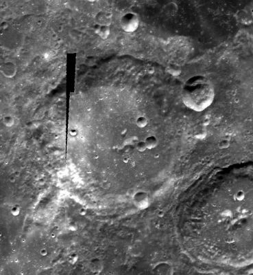
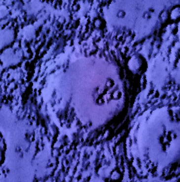
Bose is a crater of the Nectarian period (~ 3.92 to 3.85 bn years), and lies smack in the centre (54.2S, 168.7W) of the South Pole Aitken Basin -- a 2500 kilometre-wide basin of the pre-Nectarian period (~ 4.6 to 3.92 bn years). Except for part of its northern section, most, if not all, of Bose's rim has either been well worn down through age, or, shaped by subsequent impacts that followed after its formation. Two contrasting features to Bose's internal appearance is that most of its south-western wall show signs of terracing, the opposite is true for its north-eastern section which show signs of a grooved appearance. Has this anything to do with formation processes, impacts in the region, or with material make-up? Bose's floor is relatively flat overall, but there are signs of peaks just off-centre, as well as a trio of small impact craters all roughly at 10 kilometres accross to the peak's east. - JohnMoore2
Description: Wikipedia
Additional Information
- Central peak composition: GNTA2, AGN & AN (Tompkins & Pieters, 1999)
- Within SPA basin, less than 90% anorthosite in central peak, and 0.2 to 0.5 Maturity Index (not mature) Ohtake and others, 2009
Nomenclature
- Jagdish Chandra Bose (November 30, 1858 - November 23, 1937) was a Bengali physicist and science fiction writer, who pioneered the investigation of radio and microwave optics, made extremely significant contributions to plant science, and laid the foundations of experimental science in the Indian subcontinent. He is considered the father of radio science, and is also considered the father of Bengali science fiction. He was the first from the Indian subcontinent to get a US patent, in 1904. Bose’s place in history has now been re-evaluated, and he is credited with the invention of the first wireless detection device and the discovery of millimetre length electromagnetic waves and considered a pioneer in the field of biophysics.
- An officially unnamed dark region immediately northeast of Bose is called Lacus Bose by Danny Caes. It should be mentioned that there's a curious system of wrinkle ridges on the floor of this lake. This system of wrinkle ridges is called Dorsa Bose by Danny Caes.
- Don't know if it's really a name, the Bose-Alder Plains, but... they are frequently mentioned in the LROC RDR Products pages.
LPOD Articles
Bibliography

