Difference between revisions of "Vallis Bohr"
| Line 6: | Line 6: | ||
|} | |} | ||
<div id="toc"> | <div id="toc"> | ||
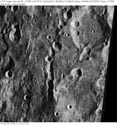
| − | [http://www.lpod.org/coppermine/albums/userpics/Vallis_Bohr_LO-IV-188H_LTVT.JPG [[Image: | + | [http://www.lpod.org/coppermine/albums/userpics/Vallis_Bohr_LO-IV-188H_LTVT.JPG [[Image:Normal_Vallis_Bohr_LO-IV-188H_LTVT.JPG|external image normal_Vallis_Bohr_LO-IV-188H_LTVT.JPG]]]<br /> ''Image source: [http://lpod.org/coppermine/displayimage.php?pos=-1995 LO-IV-188H]'' '''Vallis Bohr''' is the cleft down the center of the image. The crater to the upper right is [[Bohr|Bohr]]. The large crater in the lower right is not named.<br /> <br /> |
==Images== | ==Images== | ||
[http://www.lpod.org/coppermine/thumbnails.php?album=search&type=full&search=Vallis%20Bohr LPOD Photo Gallery] [http://www.lpi.usra.edu/resources/lunar_orbiter/bin/srch_nam.shtml?Vallis%20Bohr%7C0 Lunar Orbiter Images]<br /> <br /> | [http://www.lpod.org/coppermine/thumbnails.php?album=search&type=full&search=Vallis%20Bohr LPOD Photo Gallery] [http://www.lpi.usra.edu/resources/lunar_orbiter/bin/srch_nam.shtml?Vallis%20Bohr%7C0 Lunar Orbiter Images]<br /> <br /> | ||
Latest revision as of 02:20, 16 April 2018
Contents
Vallis Bohr
|
Lat: 10.25°N, Long: 88.86°W, Length: 95.32 km, Depth: km, Rükl: 28 |
Image source: LO-IV-188H Vallis Bohr is the cleft down the center of the image. The crater to the upper right is Bohr. The large crater in the lower right is not named.
Images
LPOD Photo Gallery Lunar Orbiter Images
Maps
(LAC zone 55A1) USGS Digital Atlas PDF
Description
Wikipedia
Additional Information
- IAU page: Vallis Bohr
- The coordinates and length given in the title line are from the IAU Planetary Gazetteer. Measurements on a calibrated copy of Lunar Orbiter image IV-188H with LTVT suggest the length of the main part of the valley is 98 km. If the faint extension to the northeast is part of it, the overall length would exceed 150 km. The width of the main part varies from about 10 km in the north to 12 km in the south. The shadows indicate the northern segment is about 1250 m deep. In the 12 km wide southern segment the depth increases to something over 2700 m (since the shadows do not extend to the deepest point, the true depth could be considerably greater). - Jim Mosher
Dark halo crater near Vallis Bohr
- Unnamed bowl-shaped crater with dark (read: low albedo) halo at 90 degrees West/ 9 degrees North; immediately west of the southern part of Vallis Bohr. Take a look at the left margin of photographic chart LAC 55 (page 110) in the Clementine Atlas of the Moon (Ben Bussey/ Paul Spudis). - DannyCaes Aug 17, 2015
- Is this dark halo crater observable during very favourable libration? - DannyCaes Aug 17, 2015
- There's a small Floor Fractured Crater (FFC) immediately south of that dark halo crater, see the lower margin of Lunar Orbiter IV photograph IV-4188-h2. - DannyCaes Aug 17, 2015
Nomenclature
- Named from nearby crater (Bohr).
- This name was officially adopted in 1976. The IAU Planetary Gazetteer at one time gave the feature the same coordinates (12.4 N, 86.6 W) and essentially the same dimensions as the crater Bohr, but according to Bowker and Hughes (1971) the name refers to the valley to the southwest. - Jim Mosher
LPOD Articles
Bibliography
Named Features -- Prev: Bohr -- Next: Bok
