Difference between revisions of "Mare Fecunditatis"
| Line 6: | Line 6: | ||
Lat: 7.8°S, Long: 51.3°E, Main ring diam: 690 km, Basin depth: 1.84 km, [[R%C3%BCkl%2048|Rükl: 48]]<br /> | Lat: 7.8°S, Long: 51.3°E, Main ring diam: 690 km, Basin depth: 1.84 km, [[R%C3%BCkl%2048|Rükl: 48]]<br /> | ||
|} | |} | ||
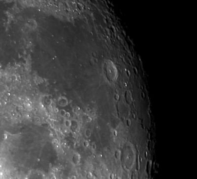
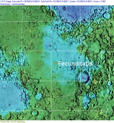
| − | [http://www.lpod.org/coppermine/displayimage.php?pid=1474&fullsize=1 [[Image: | + | [http://www.lpod.org/coppermine/displayimage.php?pid=1474&fullsize=1 [[Image:Normal_fecundatis04025.jpg|external image normal_fecundatis04025.jpg]]][http://www.lpod.org/coppermine/displayimage.php?pid=2324&fullsize=1 [[Image:Normal_Fecunditatis_Basin_LIDAR_LTVT.JPG|external image normal_Fecunditatis_Basin_LIDAR_LTVT.JPG]]]<br /> Left: ''[http://lpod.org/coppermine/displayimage.php?pos=-1474 Eric Soucy]'', Right: ''[http://lpod.org/coppermine/displayimage.php?pos=-2324 Clementine]'', Clementine LIDAR Altimeter texture from [http://pdsmaps.wr.usgs.gov/PDS/public/explorer/html/lidrlvls.htm PDS Map-a-Planet] remapped to north-up aerial view by [http://www.henriksucla.dk/ LTVT]. The dot is the center position and the white circle the main ring position from Chuck Wood's [http://www.lpod.org/cwm/DataStuff/Lunar%20Basins.htm Impact Basin Database]. Grid spacing = 10 degrees.<br /> <br /> <div id="toc"> |
==Images== | ==Images== | ||
Latest revision as of 03:03, 16 April 2018
Contents
[hide]Fecunditatis Basin
(unofficial name; IAU feature name for central 909 km of mare: Mare Fecunditatis, formerly Mare Foecunditatis )
|
Lat: 7.8°S, Long: 51.3°E, Main ring diam: 690 km, Basin depth: 1.84 km, Rükl: 48 |


Left: Eric Soucy, Right: Clementine, Clementine LIDAR Altimeter texture from PDS Map-a-Planet remapped to north-up aerial view by LTVT. The dot is the center position and the white circle the main ring position from Chuck Wood's Impact Basin Database. Grid spacing = 10 degrees.
Images
LPOD Photo Gallery Lunar Orbiter Images Apollo Images
Maps
(LAC zone 80A4) LAC map Geologic map LTO map
Basin Classification
(description of terms and most numeric basin data from Wood, C.A. (2004) Impact Basin Database)
| Certainty of Existence |
USGS Age |
Wilhelms Age Group |
Ring Diameters |
Mare Thickness |
Mascon |
| Uncertain |
Pre-Nectarian |
3 |
690, 990 km |
No |
Description
Description: Wikipedia
Additional Information
- 1970, Sept.: Luna 16 - first automated sample return, from Mare Fecunditatis
- Mare area of 220,000 km^2 according to measurements by Jim Whitford-Stark.
Nomenclature
- Called Mare Langrenianum by the father of selenography Michel Florent Van Langren (aka Langrenus).
- Called Mare Caspium by Johann Hewelcke (aka Hevelius).
- Called Mare Fecunditatis (or Mare Foecunditatis) by Giovanni Baptista Riccioli.
- The IAU feature name (Mare Fecunditatis) means "Sea of Fecundity" (or Fertility / Fruitfulness).
- The impact basin is named after the mare.
- The craters Taruntius G (Anville), Taruntius H, Taruntius K, and Taruntius P (all of them in the north-northwestern part of Mare Fecunditatis) were frequently photographed during several missions of the Apollo program. All four craters together look like some sort of "Constellation", or rather a "Constellation of Four" (thus nicknamed by Danny Caes, who's investigating all orbital Apollo photographs of these four craters, see page Anville).
LPOD Articles
Fecund Questions A Shallow Sea of Lava North-western surface Basin and lava Mare ridges Rays
LROC Articles
Mare Pit Topography! (Skylight in Mare Fecunditatis, unofficially called the Central Mare Fecunditatis Pit).
Bibliography
Rajmon, D & P Spudis (2000) Geology and Stratigraphy of Mare Fecunditatis. Lunar & Planetary Science 31, 1913.