Difference between revisions of "Lippmann"
| Line 5: | Line 5: | ||
|} | |} | ||
<div id="toc"> | <div id="toc"> | ||
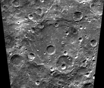
| − | [http://www.lpod.org/coppermine/displayimage.php?pid=1326&fullsize=1 [[Image: | + | [http://www.lpod.org/coppermine/displayimage.php?pid=1326&fullsize=1 [[Image:Normal_lippmann-clem1.jpg|external image normal_lippmann-clem1.jpg]]]<br /> ''[http://lpod.org/coppermine/displayimage.php?pos=-1326 Clementine]''<br /> <br /> |
==Images== | ==Images== | ||
[http://www.lpod.org/coppermine/thumbnails.php?album=search&type=full&search=Lippmann LPOD Photo Gallery] [http://www.lpi.usra.edu/resources/lunar_orbiter/bin/srch_nam.shtml?Lippmann%7C0 Lunar Orbiter Images]<br /> <br /> | [http://www.lpod.org/coppermine/thumbnails.php?album=search&type=full&search=Lippmann LPOD Photo Gallery] [http://www.lpi.usra.edu/resources/lunar_orbiter/bin/srch_nam.shtml?Lippmann%7C0 Lunar Orbiter Images]<br /> <br /> | ||
Revision as of 02:01, 16 April 2018
Contents
Lippmann (once known as Boltzmann)
| Lat: 56.0°S, Long: 114.9°W, Diam: 160 km, Depth: km, Rükl: (farside) |
Images
LPOD Photo Gallery Lunar Orbiter Images
Maps
(LAC zone 134C2) USGS Digital Atlas PDF
Description
Description: Wikipedia
Additional Information
- There's a possible narrow valley or chain of depressions (catena) near the northwestern part of Lippmann's rim, running north-northeast toward the western part of Mendel's rim. The source of it could be the impact basin Mare Orientale. Research Danny Caes (see also: Clementine Atlas of the Moon, page 268/ LAC 134).
- Curious looking (officially unnamed) peak northwest of Lippmann, at 50°30' South/ 123°30' West, noticeable on page 268 (LAC 134) in the Clementine Atlas of the Moon. The question if this peak is also noticeable on page 101 (Chart F4; Farside S.E. Quadrant) in the 21st Century Atlas of the Moon remains something to be answered.- DannyCaes Feb 6, 2013
- This peak (northwest of Lippmann) was captured in the centre of Lunar Orbiter 5's frame LOV-022-h1.- DannyCaes Feb 6, 2013
- This peak has a twin 80 km to its northeast, both tower above 6.000 mts and very likely belong to an SPA basin ring - Nunki Nunki Feb 8, 2013
Nomenclature
- Named for Gabriel Lippmann (1845-1921), a French physicist and Nobel laureate.
- In preparing its initial long list of farside names, the IAU Working Group for Lunar Nomenclature announced at the August 1970 IAU meeting its plan of assigning the name Boltzmann to this feature, but reversed its decision before issuing the final list in June, 1971.
- The name "Lippman" [sic] was announced in 1976 as being in a bank of names for possible future use.
- The present crater was labelled Lippmann on NASA's LPC-1 (February, 1979) and the name was approved by the IAU "as assigned" at its 1979 meeting.
- This crater is labeled Boltzmann on several farside maps, for example: Antonin Rükl's and on the 2nd Edition of NASA's LMP-3 (prepared in October, 1970 -- after the August IAU meeting, but before the final list was released in June, 1971). Research: Danny Caes.
- The narrow valley or chain of depressions near the northwestern part of Lippmann's rim is unofficially called Vallis Lippmann-Mendel (or Catena Lippmann-Mendel) by D.Caes.
- The two peaks northwest of Lippmann and west of Mendel (see Additional Information, above) are unofficially called the Farside Twin Peaks. Thanks Nunki! - DannyCaes Feb 8, 2013
LPOD Articles
Bibliography
