Difference between revisions of "Cannizzaro"
| Line 10: | Line 10: | ||
|} | |} | ||
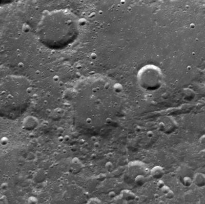
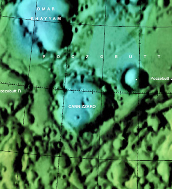
'''Left:''' ''[http://pdsmaps.wr.usgs.gov/explorer-bin/mapmars4.cgi?WHEREFROM=COLOR&VERSION=INTERMEDIATE&DATA_SET_NAME=moon_clementine_bw&PIXEL_TYPE=BIT8&SCALE=pixels/degree&PROJECTION=SINUSOIDAL&RESOLUTION=64&RESAMP_METHOD=NEAREST_NEIGHBOR&BANDS_SELECTED=&FORMAT=JPEG&LONBOX=32&LATBOX=32&GRIDLINE_FREQUENCY=none&STRETCH=NONE&LAT=59.5&LON=263.5&LINE=2048&SAMP=1486 Clementine] image from [http://pdsmaps.wr.usgs.gov/PDS/public/explorer/html/lidrintm.htm PDS Map-A-Planet]. '''Right:''' [http://planetarynames.wr.usgs.gov/images/Lunar/lac_21.pdf Colo-coded Lac 21] from [[USGS%20Digital%20Atlas|USGS Digital Atlas]]''<br /> ''Click [http://planetarynames.wr.usgs.gov/jsp/AdvanceSearch2.jsp?body=Moon&ft=ALL&nlat=57&slat=54.2&wlon=-101.7&elon=-96.7&lonDirection=EAST&as=ANY&sort=AName&ShowType=Yes&ShowDiam=Yes&ShowLat=Yes&ShowLon=Yes&ShowAD=Yes here] for a USGS-generated list of all [[IAU|IAU]]-named features with centers in the current field.''<br /> <div id="toc"> | '''Left:''' ''[http://pdsmaps.wr.usgs.gov/explorer-bin/mapmars4.cgi?WHEREFROM=COLOR&VERSION=INTERMEDIATE&DATA_SET_NAME=moon_clementine_bw&PIXEL_TYPE=BIT8&SCALE=pixels/degree&PROJECTION=SINUSOIDAL&RESOLUTION=64&RESAMP_METHOD=NEAREST_NEIGHBOR&BANDS_SELECTED=&FORMAT=JPEG&LONBOX=32&LATBOX=32&GRIDLINE_FREQUENCY=none&STRETCH=NONE&LAT=59.5&LON=263.5&LINE=2048&SAMP=1486 Clementine] image from [http://pdsmaps.wr.usgs.gov/PDS/public/explorer/html/lidrintm.htm PDS Map-A-Planet]. '''Right:''' [http://planetarynames.wr.usgs.gov/images/Lunar/lac_21.pdf Colo-coded Lac 21] from [[USGS%20Digital%20Atlas|USGS Digital Atlas]]''<br /> ''Click [http://planetarynames.wr.usgs.gov/jsp/AdvanceSearch2.jsp?body=Moon&ft=ALL&nlat=57&slat=54.2&wlon=-101.7&elon=-96.7&lonDirection=EAST&as=ANY&sort=AName&ShowType=Yes&ShowDiam=Yes&ShowLat=Yes&ShowLon=Yes&ShowAD=Yes here] for a USGS-generated list of all [[IAU|IAU]]-named features with centers in the current field.''<br /> <div id="toc"> | ||
| − | + | ||
| − | |||
==Images== | ==Images== | ||
[http://www.lpod.org/coppermine/thumbnails.php?album=search&type=full&search=Cannizzaro LPOD Photo Gallery] [http://www.lpi.usra.edu/resources/lunar_orbiter/bin/srch_nam.shtml?Cannizzaro%7C0 Lunar Orbiter Images]<br /> | [http://www.lpod.org/coppermine/thumbnails.php?album=search&type=full&search=Cannizzaro LPOD Photo Gallery] [http://www.lpi.usra.edu/resources/lunar_orbiter/bin/srch_nam.shtml?Cannizzaro%7C0 Lunar Orbiter Images]<br /> | ||
| Line 36: | Line 35: | ||
<br /> <br /> | <br /> <br /> | ||
---- | ---- | ||
| − | + | </div> | |
Revision as of 16:16, 15 April 2018
Contents
Cannizzaro
| Lat: 55.6°N, Long: 99.6°W, Diam: 56 km, Depth: km, Rükl: (farside) | |
Click here for a USGS-generated list of all IAU-named features with centers in the current field.
Images
LPOD Photo Gallery Lunar Orbiter Images
- Cannizzaro is detectable in Lunar Orbiter IV's frame LO-IV-190-med, on the southern part of Poczobutt's floor (in this photograph not far from the local morning terminator).
- Research Lunar Orbiter IV photography: Danny Caes
Maps
(LAC zone 21D2) USGS Digital Atlas PDF
Description
Cannizzaro lies on the south-western rim of Poczobutt crater -- a 195 kilometre-wide crater of the pre-Nectarian period (~ 4.6 to 3.92 bn years), and west of both Basins Procellarum and Imbrium respectively. The crater itself looks very worn with nearly every portion of its rim affected by either smaller impacts craters, wall collapse, or more importantly, ejecta deposits from the Imbrium Basin nearby. These events have thus softened its overall appearance, and implied a contraint as to its exact age. The floor of the crater has, undoubtedly, received its fair portion of this said ejecta, leaving both a half-buried hill (or peak) in the centre exposed, along with numerous impacts in its surrounds that look relatively fresh.- JohnMoore2 JohnMoore2
Description: Wikipedia
Additional Information
Nomenclature
- Named for Stanislao Cannizzaro (1826-1910), an Italian chemist.
- Cannizzaro was in the long list of farside names approved by the IAU in 1970 and published in Menzel, 1971.
- Although Cannizzaro is a crater of 56 km diameter on the southern part of the degraded walled plain Poczobutt, its name (-Cannizzaro-) was not printed on LAC 21 (page 43) in the Clementine Atlas of the Moon (first edition of 2004).
LPOD Articles
Bibliography

