Difference between revisions of "Elger"
(Created page with "<div id="content_view" class="wiki" style="display: block"> =Elger= {| class="wiki_table" | Lat: 35.3°S, Long: 29.8°W, Diam: 21 km, Depth: 1.26 km, [/R%C3%BCkl%2063 Rük...") |
|||
| Line 3: | Line 3: | ||
{| class="wiki_table" | {| class="wiki_table" | ||
| | | | ||
| − | Lat: 35.3°S, Long: 29.8°W, Diam: 21 km, Depth: 1.26 km, [ | + | Lat: 35.3°S, Long: 29.8°W, Diam: 21 km, Depth: 1.26 km, [[R%C3%BCkl%2063|Rükl: 63]]<br /> |
|} | |} | ||
<div id="toc"> | <div id="toc"> | ||
| Line 11: | Line 11: | ||
[http://www.lpod.org/coppermine/thumbnails.php?album=search&type=full&search=Elger LPOD Photo Gallery] [http://www.lpi.usra.edu/resources/lunar_orbiter/bin/srch_nam.shtml?Elger%7C0 Lunar Orbiter Images]<br /> <br /> | [http://www.lpod.org/coppermine/thumbnails.php?album=search&type=full&search=Elger LPOD Photo Gallery] [http://www.lpi.usra.edu/resources/lunar_orbiter/bin/srch_nam.shtml?Elger%7C0 Lunar Orbiter Images]<br /> <br /> | ||
==Maps== | ==Maps== | ||
| − | ''([ | + | ''([[LAC%20zone|LAC zone]] 111A2)'' [http://www.lpi.usra.edu/resources/mapcatalog/LAC/lac111/ LAC map] [http://www.lpi.usra.edu/resources/mapcatalog/usgs/I824/ Geologic map]<br /> <br /> |
==Description== | ==Description== | ||
<br /> | <br /> | ||
| Line 17: | Line 17: | ||
[http://en.wikipedia.org/wiki/Elger_(crater) Elger]<br /> <br /> | [http://en.wikipedia.org/wiki/Elger_(crater) Elger]<br /> <br /> | ||
==Additional Information== | ==Additional Information== | ||
| − | * Depth data from [ | + | * Depth data from [[Kurt%20Fisher%20crater%20depths|Kurt Fisher database]] |
** Arthur, 1974: 1.26 km | ** Arthur, 1974: 1.26 km | ||
** Westfall, 2000: 1.26 km | ** Westfall, 2000: 1.26 km | ||
** Viscardy, 1985: 1.25 km | ** Viscardy, 1985: 1.25 km | ||
| − | * [ | + | * [[LTVT|LTVT]] returns a maximum depth of 1,100 m based on the shadow in LO-IV-131-H3. The depth of the small crater just above Elger is approximately 740 m. <span class="membersnap">- [http://www.wikispaces.com/user/view/JimMosher [[Image:JimMosher-lg.jpg|16px|JimMosher]]] [http://www.wikispaces.com/user/view/JimMosher JimMosher]</span> |
<br /> | <br /> | ||
==Nomenclature== | ==Nomenclature== | ||
| − | * Named for [http://en.wikipedia.org/wiki/Thomas_Gwyn_Elger Thomas Gwyn Empy Elger] (October 27, 1836 – January 9, 1897), a lunar mapper and the first director of the Lunar Section of the British Astronomical Association ([ | + | * Named for [http://en.wikipedia.org/wiki/Thomas_Gwyn_Elger Thomas Gwyn Empy Elger] (October 27, 1836 – January 9, 1897), a lunar mapper and the first director of the Lunar Section of the British Astronomical Association ([[BAA|BAA]]). He is best known as a careful and indefatigable selenographer. He is most remembered for his book ''[[Elger%2C%201895|The Moon: A full Description and Map of its Principal Physical Features]]''. Published in 1895, its maps are still highly regarded by lunar observers due to their uncluttered nature. |
* An account of the recovery of Elger's nearly-lost observing books appears starting on [http://articles.adsabs.harvard.edu/cgi-bin/nph-iarticle_query?journal=JBAA.&year=%3f%3f%3f%3f&volume=..66&letter=.&db_key=PRE&page_ind=54&plate_select=NO&data_type=GIF&type=SCREEN_GIF&classic=YES page 46] of the January 1956 issue of ''JBAA''. | * An account of the recovery of Elger's nearly-lost observing books appears starting on [http://articles.adsabs.harvard.edu/cgi-bin/nph-iarticle_query?journal=JBAA.&year=%3f%3f%3f%3f&volume=..66&letter=.&db_key=PRE&page_ind=54&plate_select=NO&data_type=GIF&type=SCREEN_GIF&classic=YES page 46] of the January 1956 issue of ''JBAA''. | ||
<br /> | <br /> | ||
Revision as of 14:47, 15 April 2018
Contents
Elger
|
Lat: 35.3°S, Long: 29.8°W, Diam: 21 km, Depth: 1.26 km, Rükl: 63 |
Table of Contents
[#Elger Elger]
[#Elger-Images Images]
[#Elger-Maps Maps]
[#Elger-Description Description]
[#Elger-Description: Wikipedia Description: Wikipedia]
[#Elger-Additional Information Additional Information]
[#Elger-Nomenclature Nomenclature]
[#Elger-LPOD Articles LPOD Articles]
[#Elger-Bibliography Bibliography]
[#Elger-T. G. E. Elger in the Sourcebook Project (William R. Corliss) T. G. E. Elger in the Sourcebook Project (William R. Corliss)]
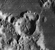
 LO4-131-h3
Images
LPOD Photo Gallery Lunar Orbiter Images
Maps
(LAC zone 111A2) LAC map Geologic map
Description
Description: Wikipedia
Additional Information
- Depth data from Kurt Fisher database
- Arthur, 1974: 1.26 km
- Westfall, 2000: 1.26 km
- Viscardy, 1985: 1.25 km
- LTVT returns a maximum depth of 1,100 m based on the shadow in LO-IV-131-H3. The depth of the small crater just above Elger is approximately 740 m. - JimMosher JimMosher
Nomenclature
- Named for Thomas Gwyn Empy Elger (October 27, 1836 – January 9, 1897), a lunar mapper and the first director of the Lunar Section of the British Astronomical Association (BAA). He is best known as a careful and indefatigable selenographer. He is most remembered for his book The Moon: A full Description and Map of its Principal Physical Features. Published in 1895, its maps are still highly regarded by lunar observers due to their uncluttered nature.
- An account of the recovery of Elger's nearly-lost observing books appears starting on page 46 of the January 1956 issue of JBAA.
LPOD Articles
Bibliography
T. G. E. Elger in the Sourcebook Project (William R. Corliss)
- In Mysterious Universe, a handbook of astronomical anomalies (1979) :
- Page 200: The Linné Controversy: a look into the past (Patrick Moore, Journal of the British Astronomical Association, 1977).
- Page 205: Three Riddles of Plato (Jackson T. Carle, Sky and Telescope, 1955).
- Page 239: Lunar Luminescence (E.J.Flamm, et al, Nature, 1965).
This page has been edited 1 times. The last modification was made by - tychocrater tychocrater on Jun 13, 2009 3:24 pm - afx2u2