Difference between revisions of "Lindbergh"
| Line 1: | Line 1: | ||
<div id="content_view" class="wiki" style="display: block"> | <div id="content_view" class="wiki" style="display: block"> | ||
=Lindbergh= | =Lindbergh= | ||
| − | ''(formerly '''[ | + | ''(formerly '''[[Messier|Messier]] G''')''<br /> |
{| class="wiki_table" | {| class="wiki_table" | ||
| Lat: 5.4°S, Long: 52.9°E, Diam: 12 km, Depth: 1.89 km, Rükl: 48<br /> | | Lat: 5.4°S, Long: 52.9°E, Diam: 12 km, Depth: 1.89 km, Rükl: 48<br /> | ||
| Line 11: | Line 11: | ||
[http://www.lpod.org/coppermine/thumbnails.php?album=search&type=full&search=Lindbergh LPOD Photo Gallery] [http://www.lpi.usra.edu/resources/lunar_orbiter/bin/srch_nam.shtml?Lindbergh%7C0 Lunar Orbiter Images] [http://www.lpi.usra.edu/resources/apollo/search/feature/?feature=Messier%20G Apollo Images]<br /> <br /> | [http://www.lpod.org/coppermine/thumbnails.php?album=search&type=full&search=Lindbergh LPOD Photo Gallery] [http://www.lpi.usra.edu/resources/lunar_orbiter/bin/srch_nam.shtml?Lindbergh%7C0 Lunar Orbiter Images] [http://www.lpi.usra.edu/resources/apollo/search/feature/?feature=Messier%20G Apollo Images]<br /> <br /> | ||
==Maps== | ==Maps== | ||
| − | ''([ | + | ''([[LAC%20zone|LAC zone]] 80A4)'' [http://www.lpi.usra.edu/resources/mapcatalog/LAC/lac80/ LAC map] [http://www.lpi.usra.edu/resources/mapcatalog/usgs/I739/ Geologic map] [http://www.lpi.usra.edu/resources/mapcatalog/LTO/lto80a4_1/ LTO map]<br /> <br /> |
==Description== | ==Description== | ||
<br /> | <br /> | ||
| Line 17: | Line 17: | ||
[http://en.wikipedia.org/wiki/Lindbergh_(crater) Lindbergh]<br /> <br /> | [http://en.wikipedia.org/wiki/Lindbergh_(crater) Lindbergh]<br /> <br /> | ||
==Additional Information== | ==Additional Information== | ||
| − | Depth data from [ | + | Depth data from [[Kurt%20Fisher%20crater%20depths|Kurt Fisher database]]<br /> |
* Westfall, 2000: 1.89 km | * Westfall, 2000: 1.89 km | ||
<br /> | <br /> | ||
| Line 23: | Line 23: | ||
[http://en.wikipedia.org/wiki/Charles_Lindbergh Charles Augustus Lindbergh] (February 4, 1902 – August 26, 1974), known as "Lucky Lindy," was an American pilot famous for the first solo, non-stop flight across the Atlantic, from Roosevelt Field, Long Island, NY to Paris in 1927 in the "Spirit of St. Louis." In the ensuing deluge of publicity, Lindbergh became the world's best-known aviator.<br /> | [http://en.wikipedia.org/wiki/Charles_Lindbergh Charles Augustus Lindbergh] (February 4, 1902 – August 26, 1974), known as "Lucky Lindy," was an American pilot famous for the first solo, non-stop flight across the Atlantic, from Roosevelt Field, Long Island, NY to Paris in 1927 in the "Spirit of St. Louis." In the ensuing deluge of publicity, Lindbergh became the world's best-known aviator.<br /> | ||
| − | * This replacement name for a formerly [ | + | * This replacement name for a formerly [[lettered%20crater|lettered crater]] was introduced on [http://www.lpi.usra.edu/resources/mapcatalog/LTO/lto80a4_1/ LTO-80A4] (for which it served as the chart title). <span class="membersnap">- [http://www.wikispaces.com/user/view/JimMosher [[Image:JimMosher-lg.jpg|16px|JimMosher]]] [http://www.wikispaces.com/user/view/JimMosher JimMosher]</span> |
<br /> <u>Additional note</u>''':''' a small craterlet in the '''Taurus-Littrow Valley''' (the landing site of Apollo 17) seems to have been called '''Spirit''' (''Spirit of St Louis'').<br /> | <br /> <u>Additional note</u>''':''' a small craterlet in the '''Taurus-Littrow Valley''' (the landing site of Apollo 17) seems to have been called '''Spirit''' (''Spirit of St Louis'').<br /> | ||
Revision as of 15:01, 15 April 2018
Contents
Lindbergh
(formerly Messier G)
| Lat: 5.4°S, Long: 52.9°E, Diam: 12 km, Depth: 1.89 km, Rükl: 48 |
Table of Contents
[#Lindbergh Lindbergh]
[#Lindbergh-Images Images]
[#Lindbergh-Maps Maps]
[#Lindbergh-Description Description]
[#Lindbergh-Description: Wikipedia Description: Wikipedia]
[#Lindbergh-Additional Information Additional Information]
[#Lindbergh-Nomenclature Nomenclature]
[#Lindbergh-LPOD Articles LPOD Articles]
[#Lindbergh-Bibliography Bibliography]

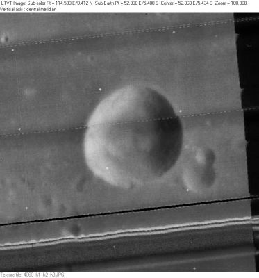
LO-IV-060H The small craters on the right are unnamed.
Images
LPOD Photo Gallery Lunar Orbiter Images Apollo Images
Maps
(LAC zone 80A4) LAC map Geologic map LTO map
Description
Description: Wikipedia
Additional Information
Depth data from Kurt Fisher database
- Westfall, 2000: 1.89 km
Nomenclature
Charles Augustus Lindbergh (February 4, 1902 – August 26, 1974), known as "Lucky Lindy," was an American pilot famous for the first solo, non-stop flight across the Atlantic, from Roosevelt Field, Long Island, NY to Paris in 1927 in the "Spirit of St. Louis." In the ensuing deluge of publicity, Lindbergh became the world's best-known aviator.
- This replacement name for a formerly lettered crater was introduced on LTO-80A4 (for which it served as the chart title). - JimMosher JimMosher
Additional note: a small craterlet in the Taurus-Littrow Valley (the landing site of Apollo 17) seems to have been called Spirit (Spirit of St Louis).
- Spirit (crater) - "'The Spirit of St. Louis' honors not only the historic achievement of Charles Lindbergh, but also the search by Lindbergh and others for the reasons for uniqueness in the human spirit." (source: APOLLO LUNAR SURFACE JOURNAL, Eric M. Jones).
LPOD Articles
Bibliography
This page has been edited 1 times. The last modification was made by - tychocrater tychocrater on Jun 13, 2009 3:24 pm - afx3u2