Difference between revisions of "LPOD May 21, 2008"
| Line 1: | Line 1: | ||
<div id="content_view" class="wiki" style="display: block"> | <div id="content_view" class="wiki" style="display: block"> | ||
=APENNINE SNOWS= | =APENNINE SNOWS= | ||
| − | [[Image:LPOD-May21-08.jpg|LPOD-May21-08.jpg]]<br /> ''image by Kaguya/Selene, [http://www.jaxa.jp/press/2008/05/20080520_kaguya_j.html JAXA.]''<br /> <br /> Looking like a poster for an exotic ski resort, this remarkable image was constructed from high resolution stereo images taken with the Terrain Camera (TC) on the Kaguya/Selene spacecraft currently orbiting the Moon. I presume the process was to first create a digital terrain model from the stereo images, then drape a TC image over that, and finally view from a perspective never seen by the Apollo 15 crew. The tall peak is [ | + | [[Image:LPOD-May21-08.jpg|LPOD-May21-08.jpg]]<br /> ''image by Kaguya/Selene, [http://www.jaxa.jp/press/2008/05/20080520_kaguya_j.html JAXA.]''<br /> <br /> Looking like a poster for an exotic ski resort, this remarkable image was constructed from high resolution stereo images taken with the Terrain Camera (TC) on the Kaguya/Selene spacecraft currently orbiting the Moon. I presume the process was to first create a digital terrain model from the stereo images, then drape a TC image over that, and finally view from a perspective never seen by the Apollo 15 crew. The tall peak is [[Mons%20Hadley%20Delta|Mount Hadley Delta]], with Saint George crater out of view just around the left corner, and beyond that is the Apollo 15 landing site. This is a straight stretch of the [[Hadley%20Rille|Hadley Rille]], until it heads into the Hadley Delta mass and abruptly turns left, hugging the mountain edge. The rille probably formed with a flat floor (from the transported lavas), and the vee-shaped talus slope resulted from downslope movement of debris. The top edge of the rille shows the broken basalt lava flows - some boulders from the flows are visible that rolled down to the rille's floor. In fact, do you see the boulder that bounced and rolled half way down the slope, with its track behind it?<br /> <br /> ''Chuck Wood''<br /> <br /> '''Technical Details'''<br /> Thanks to Junya Terazono for making known this posting on the Japanese language version of the JAXA Kaguya website.<br /> <br /> '''Related Links'''<br /> Rükl plate 22<br /> <br /> <br /> |
---- | ---- | ||
| − | '''COMMENTS'''<br /> To [ | + | '''COMMENTS'''<br /> To [[LPOD%20Comments|post comments]] regarding this LPOD, please click [http://the-moon.us/wiki/page/edit/LPOD+May+21,+2008 here] and enter your text in the space below. You will not see the Edit tab unless you register for the wiki. ''Please do not edit the LPOD itself!''<br /> <br /> 1) Sometimes I think it would be nice to put some image of a person or house or some other large common object to get a sense of scale. Of course this would change the photo a bit. Aethrae, Andrew Martin SFO<br /> <br /> 2) Andrew, in the extraordinary '''''Lunar Sourcebook; A User's Guide To The Moon''''' (Heiken, Vaniman, French) there's an orbital photograph of a region near (or at) Mare Crisium, with a drawing of '''Mount Fuji''' on it, to get an idea of the scale (can't remember the number of the page on which it was printed).<br /> P.S.:<br /> Wonderful view of the Hadley region! Thanks JAXA!<br /> -- Danny C.<br /> <br /> 3) It looks like an old mountain road or part of stage Rally Acropolis ;)<br /> |
---- | ---- | ||
</div> | </div> | ||
Latest revision as of 14:58, 15 April 2018
APENNINE SNOWS

image by Kaguya/Selene, JAXA.
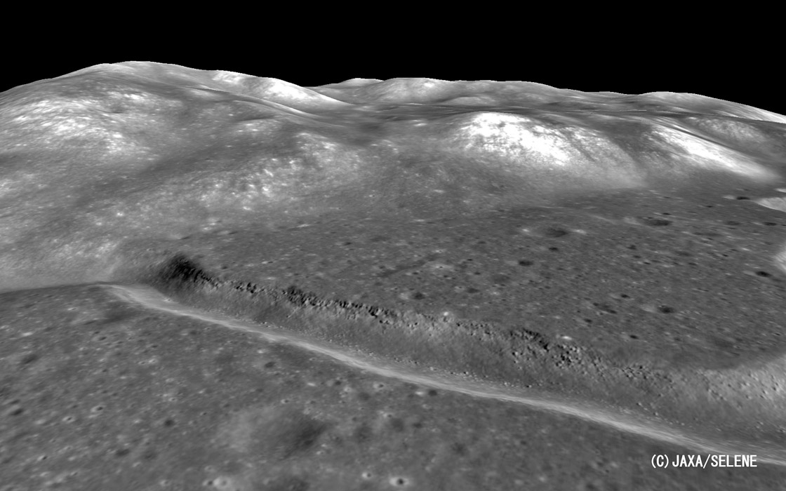
Looking like a poster for an exotic ski resort, this remarkable image was constructed from high resolution stereo images taken with the Terrain Camera (TC) on the Kaguya/Selene spacecraft currently orbiting the Moon. I presume the process was to first create a digital terrain model from the stereo images, then drape a TC image over that, and finally view from a perspective never seen by the Apollo 15 crew. The tall peak is Mount Hadley Delta, with Saint George crater out of view just around the left corner, and beyond that is the Apollo 15 landing site. This is a straight stretch of the Hadley Rille, until it heads into the Hadley Delta mass and abruptly turns left, hugging the mountain edge. The rille probably formed with a flat floor (from the transported lavas), and the vee-shaped talus slope resulted from downslope movement of debris. The top edge of the rille shows the broken basalt lava flows - some boulders from the flows are visible that rolled down to the rille's floor. In fact, do you see the boulder that bounced and rolled half way down the slope, with its track behind it?
Chuck Wood
Technical Details
Thanks to Junya Terazono for making known this posting on the Japanese language version of the JAXA Kaguya website.
Related Links
Rükl plate 22
COMMENTS
To post comments regarding this LPOD, please click here and enter your text in the space below. You will not see the Edit tab unless you register for the wiki. Please do not edit the LPOD itself!
1) Sometimes I think it would be nice to put some image of a person or house or some other large common object to get a sense of scale. Of course this would change the photo a bit. Aethrae, Andrew Martin SFO
2) Andrew, in the extraordinary Lunar Sourcebook; A User's Guide To The Moon (Heiken, Vaniman, French) there's an orbital photograph of a region near (or at) Mare Crisium, with a drawing of Mount Fuji on it, to get an idea of the scale (can't remember the number of the page on which it was printed).
P.S.:
Wonderful view of the Hadley region! Thanks JAXA!
-- Danny C.
3) It looks like an old mountain road or part of stage Rally Acropolis ;)