Difference between revisions of "Zernike"
(Created page with "<div id="content_view" class="wiki" style="display: block"> =Zernike= {| class="wiki_table" | Lat: 18.4°N, Long: 168.2°E, Diam: 48 km, Depth: km, Rükl: ''(farside)''<br...") |
|||
| Line 6: | Line 6: | ||
<div id="toc"> | <div id="toc"> | ||
=Table of Contents= | =Table of Contents= | ||
| − | <div style="margin-left: 1em">[#Zernike Zernike]</div><div style="margin-left: 2em">[#Zernike-Images Images]</div><div style="margin-left: 2em">[#Zernike-Maps Maps]</div><div style="margin-left: 2em">[#Zernike-Description Description]</div><div style="margin-left: 2em">[#Zernike-Description: Wikipedia Description: Wikipedia]</div><div style="margin-left: 2em">[#Zernike-Additional Information Additional Information]</div><div style="margin-left: 2em">[#Zernike-Nomenclature Nomenclature]</div><div style="margin-left: 2em">[#Zernike-LPOD Articles LPOD Articles]</div><div style="margin-left: 2em">[#Zernike-Bibliography Bibliography]</div></div>[http://www.mapaplanet.org/explorer-bin/explorer.cgi?map=Moon&layers=moon_clementine_multi&R=5&G=3&B=1&info=NO&advoption=YES&lines=300&samples=300&sizeSelector=resolution&Resolution=114&projection=MERC&grid=none&stretch=auto&north=19.6&south=17.2&west=166.9&east=169.5¢er=168.2&defaultcenter=on¢er_lat=0 [[Image:imageMaker.cgi|external image jpg&height=300&width=300&bbox=166.9,17.2,169.5,19.6&resamp_method=nearest_neighbor]]][[Image:Zernike.jpg|Zernike.jpg]]<br /> '''left:''' ''Clementine UV-VIS Multispectral Mosaic.'' '''right:''' ''LROC;'' '''Zernicke''' is the heavily eroded crater at center, '''Anderson''' at lower right<br /> Mercator projection dynamically created by USGS lunar [http://www.mapaplanet.org/explorer/help/wmsUserDoc.html Web Map Service]. Click [http://planetarynames.wr.usgs.gov/jsp/AdvanceSearch2.jsp?body=Moon&ft=ALL&nlat=19.6&slat=17.2&wlon=166.9&elon=169.5&lonDirection=EAST&as=ANY&sort=AName&ShowType=Yes&ShowDiam=Yes&ShowLat=Yes&ShowLon=Yes&ShowAD=Yes here] for a USGS-generated list of all [ | + | <div style="margin-left: 1em">[#Zernike Zernike]</div><div style="margin-left: 2em">[#Zernike-Images Images]</div><div style="margin-left: 2em">[#Zernike-Maps Maps]</div><div style="margin-left: 2em">[#Zernike-Description Description]</div><div style="margin-left: 2em">[#Zernike-Description: Wikipedia Description: Wikipedia]</div><div style="margin-left: 2em">[#Zernike-Additional Information Additional Information]</div><div style="margin-left: 2em">[#Zernike-Nomenclature Nomenclature]</div><div style="margin-left: 2em">[#Zernike-LPOD Articles LPOD Articles]</div><div style="margin-left: 2em">[#Zernike-Bibliography Bibliography]</div></div>[http://www.mapaplanet.org/explorer-bin/explorer.cgi?map=Moon&layers=moon_clementine_multi&R=5&G=3&B=1&info=NO&advoption=YES&lines=300&samples=300&sizeSelector=resolution&Resolution=114&projection=MERC&grid=none&stretch=auto&north=19.6&south=17.2&west=166.9&east=169.5¢er=168.2&defaultcenter=on¢er_lat=0 [[Image:imageMaker.cgi|external image jpg&height=300&width=300&bbox=166.9,17.2,169.5,19.6&resamp_method=nearest_neighbor]]][[Image:Zernike.jpg|Zernike.jpg]]<br /> '''left:''' ''Clementine UV-VIS Multispectral Mosaic.'' '''right:''' ''LROC;'' '''Zernicke''' is the heavily eroded crater at center, '''Anderson''' at lower right<br /> Mercator projection dynamically created by USGS lunar [http://www.mapaplanet.org/explorer/help/wmsUserDoc.html Web Map Service]. Click [http://planetarynames.wr.usgs.gov/jsp/AdvanceSearch2.jsp?body=Moon&ft=ALL&nlat=19.6&slat=17.2&wlon=166.9&elon=169.5&lonDirection=EAST&as=ANY&sort=AName&ShowType=Yes&ShowDiam=Yes&ShowLat=Yes&ShowLon=Yes&ShowAD=Yes here] for a USGS-generated list of all [[IAU|IAU]]-named features with centers in the current field.<br /> <br /> |
==Images== | ==Images== | ||
[http://www.lpod.org/coppermine/thumbnails.php?album=search&type=full&search=Zernike LPOD Photo Gallery] [http://www.lpi.usra.edu/resources/lunar_orbiter/bin/srch_nam.shtml?Zernike%7C0 Lunar Orbiter Images] [http://www.lpi.usra.edu/resources/apollo/search/feature/?feature=Zernike Apollo Images]<br /> - On the LPI's [http://www.lpi.usra.edu/resources/lunar_orbiter/images/aimg/ii_034_m.jpg red labeled scan of Lunar Orbiter 2's image 034 Med], the name '''Zernike''' is positioned at crater '''Spencer Jones W''' (immediately northwest of '''Spencer Jones''' itself). '''Spencer Jones W''''s location is at LAC 67. '''Zernike''' is at LAC 49.<br /> Research: Danny Caes<br /> <br /> | [http://www.lpod.org/coppermine/thumbnails.php?album=search&type=full&search=Zernike LPOD Photo Gallery] [http://www.lpi.usra.edu/resources/lunar_orbiter/bin/srch_nam.shtml?Zernike%7C0 Lunar Orbiter Images] [http://www.lpi.usra.edu/resources/apollo/search/feature/?feature=Zernike Apollo Images]<br /> - On the LPI's [http://www.lpi.usra.edu/resources/lunar_orbiter/images/aimg/ii_034_m.jpg red labeled scan of Lunar Orbiter 2's image 034 Med], the name '''Zernike''' is positioned at crater '''Spencer Jones W''' (immediately northwest of '''Spencer Jones''' itself). '''Spencer Jones W''''s location is at LAC 67. '''Zernike''' is at LAC 49.<br /> Research: Danny Caes<br /> <br /> | ||
==Maps== | ==Maps== | ||
| − | ''([ | + | ''([[LAC%20zone|LAC zone]] 49C3)'' [http://planetarynames.wr.usgs.gov/images/Lunar/lac_49.pdf USGS Digital Atlas PDF]<br /> <br /> |
==Description== | ==Description== | ||
<br /> | <br /> | ||
Revision as of 15:23, 15 April 2018
Contents
Zernike
| Lat: 18.4°N, Long: 168.2°E, Diam: 48 km, Depth: km, Rükl: (farside) |
Table of Contents
[#Zernike Zernike]
[#Zernike-Images Images]
[#Zernike-Maps Maps]
[#Zernike-Description Description]
[#Zernike-Description: Wikipedia Description: Wikipedia]
[#Zernike-Additional Information Additional Information]
[#Zernike-Nomenclature Nomenclature]
[#Zernike-LPOD Articles LPOD Articles]
[#Zernike-Bibliography Bibliography]

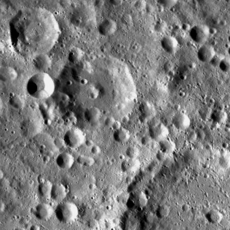
left: Clementine UV-VIS Multispectral Mosaic. right: LROC; Zernicke is the heavily eroded crater at center, Anderson at lower right
Mercator projection dynamically created by USGS lunar Web Map Service. Click here for a USGS-generated list of all IAU-named features with centers in the current field.
Images
LPOD Photo Gallery Lunar Orbiter Images Apollo Images
- On the LPI's red labeled scan of Lunar Orbiter 2's image 034 Med, the name Zernike is positioned at crater Spencer Jones W (immediately northwest of Spencer Jones itself). Spencer Jones W's location is at LAC 67. Zernike is at LAC 49.
Research: Danny Caes
Maps
(LAC zone 49C3) USGS Digital Atlas PDF
Description
Description: Wikipedia
Additional Information
It's a pleasure to explore the (possible) oblique impact craterlet at the southwestern part of Zernike W's rim. Zernike W is located northwest of Zernike itself. The bright spot of Zernike W's impact craterlet is noticeable near the lower right corner of LAC 49 (page 98) in the Clementine atlas. The pinpoint coordinates of the impact craterlet at Zernike W are: LON 166.64 / LAT 19.37 on the LRO's ACT-REACT Quick Map. - DannyCaes DannyCaes Jun 26, 2011
Nomenclature
Frits; Dutch physicist; Nobel laureate (1888-1966).
LPOD Articles
Bibliography
This page has been edited 1 times. The last modification was made by - tychocrater tychocrater on Jun 13, 2009 3:24 pm - afx4