Difference between revisions of "Rimae Opelt"
(Created page with "<div id="content_view" class="wiki" style="display: block"> =Rimae Opelt= {| class="wiki_table" | Lat: 13.0°S, Long: 18.0°W, Length: 70 km, Depth: km, [/R%C3%BCkl%2042 R...") |
|||
| Line 3: | Line 3: | ||
{| class="wiki_table" | {| class="wiki_table" | ||
| | | | ||
| − | Lat: 13.0°S, Long: 18.0°W, Length: 70 km, Depth: km, [ | + | Lat: 13.0°S, Long: 18.0°W, Length: 70 km, Depth: km, [[R%C3%BCkl%2042|Rükl: 42]]<br /> |
|} | |} | ||
<div id="toc"> | <div id="toc"> | ||
=Table of Contents= | =Table of Contents= | ||
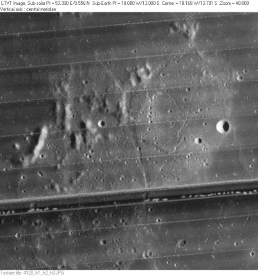
| − | <div style="margin-left: 1em">[#Rimae Opelt Rimae Opelt]</div><div style="margin-left: 2em">[#Rimae Opelt-Images Images]</div><div style="margin-left: 2em">[#Rimae Opelt-Maps Maps]</div><div style="margin-left: 2em">[#Rimae Opelt-Description Description]</div><div style="margin-left: 2em">[#Rimae Opelt-Description: Wikipedia Description: Wikipedia]</div><div style="margin-left: 2em">[#Rimae Opelt-Additional Information Additional Information]</div><div style="margin-left: 2em">[#Rimae Opelt-Nomenclature Nomenclature]</div><div style="margin-left: 2em">[#Rimae Opelt-LPOD Articles LPOD Articles]</div><div style="margin-left: 2em">[#Rimae Opelt-Bibliography Bibliography]</div></div>[http://www.lpod.org/coppermine/albums/userpics/Rimae-Opelt_LO-IV-120H_LTVT.JPG [[Image:normal_Rimae-Opelt_LO-IV-120H_LTVT.JPG|external image normal_Rimae-Opelt_LO-IV-120H_LTVT.JPG]]]<br /> ''[http://lpod.org/coppermine/displayimage.php?pos=-2626 LO-IV-120H]'' A part of '''Rimae Opelt''' crosses this unnamed set of hills between [ | + | <div style="margin-left: 1em">[#Rimae Opelt Rimae Opelt]</div><div style="margin-left: 2em">[#Rimae Opelt-Images Images]</div><div style="margin-left: 2em">[#Rimae Opelt-Maps Maps]</div><div style="margin-left: 2em">[#Rimae Opelt-Description Description]</div><div style="margin-left: 2em">[#Rimae Opelt-Description: Wikipedia Description: Wikipedia]</div><div style="margin-left: 2em">[#Rimae Opelt-Additional Information Additional Information]</div><div style="margin-left: 2em">[#Rimae Opelt-Nomenclature Nomenclature]</div><div style="margin-left: 2em">[#Rimae Opelt-LPOD Articles LPOD Articles]</div><div style="margin-left: 2em">[#Rimae Opelt-Bibliography Bibliography]</div></div>[http://www.lpod.org/coppermine/albums/userpics/Rimae-Opelt_LO-IV-120H_LTVT.JPG [[Image:normal_Rimae-Opelt_LO-IV-120H_LTVT.JPG|external image normal_Rimae-Opelt_LO-IV-120H_LTVT.JPG]]]<br /> ''[http://lpod.org/coppermine/displayimage.php?pos=-2626 LO-IV-120H]'' A part of '''Rimae Opelt''' crosses this unnamed set of hills between [[Bonpland|Bonpland]] and [[Opelt|Opelt]]. The 5-km diameter circular crater on the right is '''[[Opelt|Opelt]] K'''. The dark band across the image is a defect in the [[Lunar%20Orbiter|Lunar Orbiter]] film.<br /> <br /> |
==Images== | ==Images== | ||
[http://www.lpod.org/coppermine/thumbnails.php?album=search&type=full&search=Rimae%20Opelt LPOD Photo Gallery] [http://www.lpi.usra.edu/resources/lunar_orbiter/bin/srch_nam.shtml?Rimae%20Opelt%7C0 Lunar Orbiter Images] [http://www.lpi.usra.edu/resources/apollo/search/feature/?feature=Rimae%20Opelt Apollo Images]<br /> <br /> | [http://www.lpod.org/coppermine/thumbnails.php?album=search&type=full&search=Rimae%20Opelt LPOD Photo Gallery] [http://www.lpi.usra.edu/resources/lunar_orbiter/bin/srch_nam.shtml?Rimae%20Opelt%7C0 Lunar Orbiter Images] [http://www.lpi.usra.edu/resources/apollo/search/feature/?feature=Rimae%20Opelt Apollo Images]<br /> <br /> | ||
==Maps== | ==Maps== | ||
| − | ''([ | + | ''([[LAC%20zone|LAC zone]] 76C4)'' [http://www.lpi.usra.edu/resources/mapcatalog/LAC/lac76/ LAC map] [http://www.lpi.usra.edu/resources/mapcatalog/usgs/I458/ Geologic map] [http://www.lpi.usra.edu/resources/mapcatalog/LM/lm76/ LM map]<br /> <br /> |
==Description== | ==Description== | ||
<br /> | <br /> | ||
| Line 19: | Line 19: | ||
<br /> | <br /> | ||
==Nomenclature== | ==Nomenclature== | ||
| − | Named from nearby crater. ([ | + | Named from nearby crater. ([[Opelt|Opelt]])<br /> <br /> |
==LPOD Articles== | ==LPOD Articles== | ||
<br /> | <br /> | ||
Revision as of 15:11, 15 April 2018
Contents
Rimae Opelt
|
Lat: 13.0°S, Long: 18.0°W, Length: 70 km, Depth: km, Rükl: 42 |
Table of Contents
[#Rimae Opelt Rimae Opelt]
[#Rimae Opelt-Images Images]
[#Rimae Opelt-Maps Maps]
[#Rimae Opelt-Description Description]
[#Rimae Opelt-Description: Wikipedia Description: Wikipedia]
[#Rimae Opelt-Additional Information Additional Information]
[#Rimae Opelt-Nomenclature Nomenclature]
[#Rimae Opelt-LPOD Articles LPOD Articles]
[#Rimae Opelt-Bibliography Bibliography]

LO-IV-120H A part of Rimae Opelt crosses this unnamed set of hills between Bonpland and Opelt. The 5-km diameter circular crater on the right is Opelt K. The dark band across the image is a defect in the Lunar Orbiter film.
Images
LPOD Photo Gallery Lunar Orbiter Images Apollo Images
Maps
(LAC zone 76C4) LAC map Geologic map LM map
Description
Description: Wikipedia
Additional Information
Nomenclature
Named from nearby crater. (Opelt)
LPOD Articles
Bibliography
This page has been edited 1 times. The last modification was made by - tychocrater tychocrater on Jun 13, 2009 3:24 pm - afx3u2