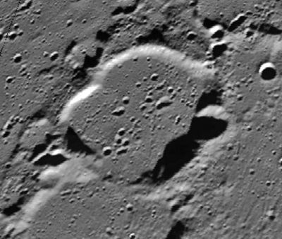
Difference between revisions of "Main"
(Created page with "<div id="content_view" class="wiki" style="display: block"> =Main= {| class="wiki_table" | Lat: 80.8°N, Long: 10.1°E, Diam: 46 km, Depth: 1.93 km, Rükl: 4, [/Stratigrap...") |
|||
| Line 3: | Line 3: | ||
{| class="wiki_table" | {| class="wiki_table" | ||
| | | | ||
| − | Lat: 80.8°N, Long: 10.1°E, Diam: 46 km, Depth: 1.93 km, Rükl: 4, [ | + | Lat: 80.8°N, Long: 10.1°E, Diam: 46 km, Depth: 1.93 km, Rükl: 4, [[Stratigraphy|Nectarian]]<br /> |
|} | |} | ||
<div id="toc"> | <div id="toc"> | ||
| Line 11: | Line 11: | ||
[http://www.lpod.org/coppermine/thumbnails.php?album=search&type=full&search=Main LPOD Photo Gallery] [http://www.lpi.usra.edu/resources/lunar_orbiter/bin/srch_nam.shtml?Main%7C0 Lunar Orbiter Images]<br /> <br /> | [http://www.lpod.org/coppermine/thumbnails.php?album=search&type=full&search=Main LPOD Photo Gallery] [http://www.lpi.usra.edu/resources/lunar_orbiter/bin/srch_nam.shtml?Main%7C0 Lunar Orbiter Images]<br /> <br /> | ||
==Maps== | ==Maps== | ||
| − | ''([ | + | ''([[LAC%20zone|LAC zone]] 1D4)'' [http://planetarynames.wr.usgs.gov/images/Lunar/lac_1.pdf USGS Digital Atlas PDF]<br /> <br /> |
==Description== | ==Description== | ||
<br /> | <br /> | ||
==Description: Elger== | ==Description: Elger== | ||
| − | ''([ | + | ''([[IAU%20Directions|IAU Directions]])'' MAIN.--A very similar formation, on the N. of [[Challis|Challis]], much too near the limb to be well observed.<br /> <br /> |
==Description: Wikipedia== | ==Description: Wikipedia== | ||
[http://en.wikipedia.org/wiki/Main_(crater) Main]<br /> <br /> | [http://en.wikipedia.org/wiki/Main_(crater) Main]<br /> <br /> | ||
==Additional Information== | ==Additional Information== | ||
| − | Depth data from [ | + | Depth data from [[Kurt%20Fisher%20crater%20depths|Kurt Fisher database]]<br /> |
* Westfall, 2000: 1.93 km | * Westfall, 2000: 1.93 km | ||
<br /> | <br /> | ||
Revision as of 15:02, 15 April 2018
Contents
Main
|
Lat: 80.8°N, Long: 10.1°E, Diam: 46 km, Depth: 1.93 km, Rükl: 4, Nectarian |
Table of Contents
[#Main Main]
[#Main-Images Images]
[#Main-Maps Maps]
[#Main-Description Description]
[#Main-Description: Elger Description: Elger]
[#Main-Description: Wikipedia Description: Wikipedia]
[#Main-Additional Information Additional Information]
[#Main-Nomenclature Nomenclature]
[#Main-LPOD Articles LPOD Articles]
[#Main-Bibliography Bibliography]

Clementine
Images
LPOD Photo Gallery Lunar Orbiter Images
Maps
(LAC zone 1D4) USGS Digital Atlas PDF
Description
Description: Elger
(IAU Directions) MAIN.--A very similar formation, on the N. of Challis, much too near the limb to be well observed.
Description: Wikipedia
Additional Information
Depth data from Kurt Fisher database
- Westfall, 2000: 1.93 km
Nomenclature
The Reverend Robert Main (July 12, 1808 – May 9, 1878) was a British astronomer. He served for twenty-five years (1835-60) as First Assistant at the Royal Greenwich Observatory, and published numerous articles, particularly on stellar and planetary motion, stellar parallax, and the dimensions and shapes of the planets.
LPOD Articles
Bibliography
This page has been edited 1 times. The last modification was made by - tychocrater tychocrater on Jun 13, 2009 3:24 pm - afx3u2