Difference between revisions of "Cabannes"
| Line 16: | Line 16: | ||
''([[LAC%20zone|LAC zone]] 133D4)'' [http://planetarynames.wr.usgs.gov/images/Lunar/lac_133.pdf USGS Digital Atlas PDF]<br /> <br /> | ''([[LAC%20zone|LAC zone]] 133D4)'' [http://planetarynames.wr.usgs.gov/images/Lunar/lac_133.pdf USGS Digital Atlas PDF]<br /> <br /> | ||
==Description== | ==Description== | ||
| − | '''Cabanes''' is a crater of the [[Stratigraphy|pre-Nectarian]] period (~ 4.6 to 3.92 bn years) and lies not far from the centre (54.2S, 168.7W) of the [[South%20Pole-Aitken%20Basin|South Pole Aitken Basin]] -- a 2500 kilometre-wide of the same age. The crater's rim, as well as the terracing all around, look well worn, while the surrounding regions has suffered numerous impacts -- the largest ('''Cabanes J''') being in the south-east. The floor of the crater is relatively flat but the southern half section looks raised slighly -- possibly due to material ejected or pushed into the area from the above-mentioned impacts. No central peak is seen in the central regions of the crater, however, this clearer [http://pdsmaps.wr.usgs.gov/explorer-bin/mapmars4.cgi?WHEREFROM=PZ&VERSION=INTERMEDIATE&DATA_SET_NAME=moon_clementine_bw&PIXEL_TYPE=BIT8&SCALE=pixels/degree&PROJECTION=SINUSOIDAL&RESOLUTION=128&RESAMP_METHOD=NEAREST_NEIGHBOR&BANDS_SELECTED=&FORMAT=JPEG&LONBOX=8&LATBOX=8&GRIDLINE_FREQUENCY=none&STRETCH=NONE&LAT=-63&LON=-171.5&LINE=1024&SAMP=496 PDS Map-A-Planet]image shows a small crater that appears to be connected to a hill in the south-west section. Is this any hint of a central peak that was later impacted to form the small crater shown? <span class="membersnap">- | + | '''Cabanes''' is a crater of the [[Stratigraphy|pre-Nectarian]] period (~ 4.6 to 3.92 bn years) and lies not far from the centre (54.2S, 168.7W) of the [[South%20Pole-Aitken%20Basin|South Pole Aitken Basin]] -- a 2500 kilometre-wide of the same age. The crater's rim, as well as the terracing all around, look well worn, while the surrounding regions has suffered numerous impacts -- the largest ('''Cabanes J''') being in the south-east. The floor of the crater is relatively flat but the southern half section looks raised slighly -- possibly due to material ejected or pushed into the area from the above-mentioned impacts. No central peak is seen in the central regions of the crater, however, this clearer [http://pdsmaps.wr.usgs.gov/explorer-bin/mapmars4.cgi?WHEREFROM=PZ&VERSION=INTERMEDIATE&DATA_SET_NAME=moon_clementine_bw&PIXEL_TYPE=BIT8&SCALE=pixels/degree&PROJECTION=SINUSOIDAL&RESOLUTION=128&RESAMP_METHOD=NEAREST_NEIGHBOR&BANDS_SELECTED=&FORMAT=JPEG&LONBOX=8&LATBOX=8&GRIDLINE_FREQUENCY=none&STRETCH=NONE&LAT=-63&LON=-171.5&LINE=1024&SAMP=496 PDS Map-A-Planet]image shows a small crater that appears to be connected to a hill in the south-west section. Is this any hint of a central peak that was later impacted to form the small crater shown? <span class="membersnap">- JohnMoore2</span><br /> <br /> |
==Description: Wikipedia== | ==Description: Wikipedia== | ||
[http://en.wikipedia.org/wiki/Cabannes_(crater) Cabannes]<br /> <br /> | [http://en.wikipedia.org/wiki/Cabannes_(crater) Cabannes]<br /> <br /> | ||
Latest revision as of 20:04, 16 April 2018
Contents
Cabannes
| Lat: 60.9°S, Long: 169.6°W, Diam: 80 km, Depth: km, Rükl: (farside) | |
Images
LPOD Photo Gallery Lunar Orbiter Images Apollo Images
Maps
(LAC zone 133D4) USGS Digital Atlas PDF
Description
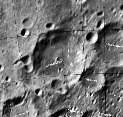
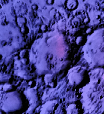
Cabanes is a crater of the pre-Nectarian period (~ 4.6 to 3.92 bn years) and lies not far from the centre (54.2S, 168.7W) of the South Pole Aitken Basin -- a 2500 kilometre-wide of the same age. The crater's rim, as well as the terracing all around, look well worn, while the surrounding regions has suffered numerous impacts -- the largest (Cabanes J) being in the south-east. The floor of the crater is relatively flat but the southern half section looks raised slighly -- possibly due to material ejected or pushed into the area from the above-mentioned impacts. No central peak is seen in the central regions of the crater, however, this clearer PDS Map-A-Planetimage shows a small crater that appears to be connected to a hill in the south-west section. Is this any hint of a central peak that was later impacted to form the small crater shown? - JohnMoore2
Description: Wikipedia
Additional Information
Nomenclature
Jean Cabannes (August 12, 1885 - October 31, 1959) was a French physicist specialising in optics. From 1910 to 1914 Cabannes worked in the laboratory of Charles Fabry in Marseille on the topic of how gas molecules diffused light. In 1914 he showed that pure gases could scatter light. In 1925 he and Jean Dufay calculated the height of the ozone layer.
LPOD Articles
Bibliography

