Difference between revisions of "Vallis Inghirami"
| Line 6: | Line 6: | ||
|} | |} | ||
<div id="toc"> | <div id="toc"> | ||
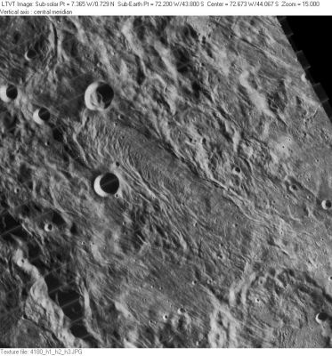
| − | [http://www.lpod.org/coppermine/albums/userpics/Vallis%20Inghirami_LO-IV-186H_LTVT.JPG [[Image: | + | [http://www.lpod.org/coppermine/albums/userpics/Vallis%20Inghirami_LO-IV-186H_LTVT.JPG [[Image:Normal_Vallis%20Inghirami_LO-IV-186H_LTVT.JPG|external image normal_Vallis%20Inghirami_LO-IV-186H_LTVT.JPG]]]<br /> ''[http://lpod.org/coppermine/displayimage.php?pos=-1901 LO-IV-180H]'' '''Vallis Inghirami''' is the tortured oblong region crossing the center of the image from upper left to lower right.<br /> <br /> |
==Images== | ==Images== | ||
[http://www.lpod.org/coppermine/thumbnails.php?album=search&type=full&search=Vallis%20Inghirami LPOD Photo Gallery] [http://www.lpi.usra.edu/resources/lunar_orbiter/bin/srch_nam.shtml?Vallis%20Inghirami%7C0 Lunar Orbiter Images]<br /> <br /> | [http://www.lpod.org/coppermine/thumbnails.php?album=search&type=full&search=Vallis%20Inghirami LPOD Photo Gallery] [http://www.lpi.usra.edu/resources/lunar_orbiter/bin/srch_nam.shtml?Vallis%20Inghirami%7C0 Lunar Orbiter Images]<br /> <br /> | ||
Latest revision as of 02:20, 16 April 2018
Contents
Vallis Inghirami
|
Lat: 43.8°S, Long: 72.2°W, Length: 148 km, Depth: km, Rükl 61 |
LO-IV-180H Vallis Inghirami is the tortured oblong region crossing the center of the image from upper left to lower right.
Images
LPOD Photo Gallery Lunar Orbiter Images
Maps
(LAC zone 109C1) USGS Digital Atlas PDF
Description
Description: Wikipedia
Additional Information
Nomenclature
- Named after the nearby crater (Inghirami).
- This name was not part of the original IAU nomenclature. It was introduced in the System of Lunar Craters.
LPOD Articles
Bibliography
Wood, C.A. Jan. 2005. Ideal Orientale. S&T 1/2005:73
  Harold Hill. 1991. A Portfolio of Lunar Drawings pages 166, 167 (the Baade-Inghirami-Bouvard valleys).
