Difference between revisions of "Mendeleev"
| Line 6: | Line 6: | ||
|- | |- | ||
| | | | ||
| − | [http://www.lpod.org/coppermine/displayimage.php?pid=3127&fullsize=1 [[Image: | + | [http://www.lpod.org/coppermine/displayimage.php?pid=3127&fullsize=1 [[Image:Normal_Mendeleev.jpg|external image normal_Mendeleev.jpg]]]<br /> |
| | | | ||
| − | [http://www.lpod.org/coppermine/displayimage.php?pid=2339&fullsize=1 [[Image: | + | [http://www.lpod.org/coppermine/displayimage.php?pid=2339&fullsize=1 [[Image:Normal_Mendeleev_Basin_LIDAR_LTVT.JPG|external image normal_Mendeleev_Basin_LIDAR_LTVT.JPG]]]<br /> |
|} | |} | ||
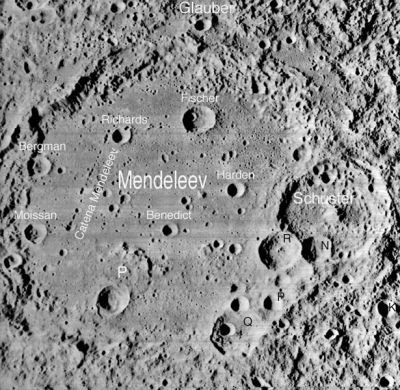
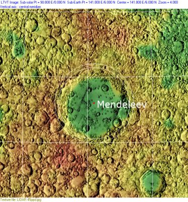
Left: ''[http://lpod.org/coppermine/displayimage.php?pos=-3127 LOI-116-M]'', Right: ''[http://lpod.org/coppermine/displayimage.php?pos=-2339 Clementine]'', Clementine LIDAR Altimeter texture from [http://pdsmaps.wr.usgs.gov/PDS/public/explorer/html/lidrlvls.htm PDS Map-a-Planet] remapped to north-up aerial view by [http://www.henriksucla.dk/ LTVT]. The dot is the center position and the white circles are estimates of the main ring position from Chuck Wood's [http://www.lpod.org/cwm/DataStuff/Lunar%20Basins.htm Impact Basin Database]. Grid spacing = 10 degrees.<br /> <div id="toc"> | Left: ''[http://lpod.org/coppermine/displayimage.php?pos=-3127 LOI-116-M]'', Right: ''[http://lpod.org/coppermine/displayimage.php?pos=-2339 Clementine]'', Clementine LIDAR Altimeter texture from [http://pdsmaps.wr.usgs.gov/PDS/public/explorer/html/lidrlvls.htm PDS Map-a-Planet] remapped to north-up aerial view by [http://www.henriksucla.dk/ LTVT]. The dot is the center position and the white circles are estimates of the main ring position from Chuck Wood's [http://www.lpod.org/cwm/DataStuff/Lunar%20Basins.htm Impact Basin Database]. Grid spacing = 10 degrees.<br /> <div id="toc"> | ||
Latest revision as of 02:04, 16 April 2018
Contents
Mendeleev Basin
(unofficial name; IAU crater name: Mendeleev, 313 km diam)
| Lat: 5.38°N, Long: 141.7°E, Main ring diam: 325.13 km, Basin depth: 4.8-5.0 km, Rükl: (farside) | |
Images
LPOD Photo Gallery Lunar Orbiter Images Apollo Images
Kaguya HDTV oblique view ASU Apollo Image Archive
Maps
Basin Classification
(description of terms and most numeric basin data from Wood, C.A. (2004) Impact Basin Database)
| Certainty of Existence |
USGS Age |
Wilhelms Age Group |
Ring Diameters |
Mare Thickness |
Mascon |
| Probable |
Nectarian |
11 |
140, 365 km |
1.0 km |
No; -40 mG gravity anomaly |
Description
Description: Wikipedia
Additional Information
- IAU page: Mendeleev
Nomenclature
- The IAU crater name honors Dmitri Ivanovich Mendeleev (1834-1907); a Russian chemist .
- The impact basin is named after the crater.
- This crater was identified in Lunik 3 imaging and given its present name in the Russian Atlas of the Far Side of the Moon (1960). The name was approved in IAU Transactions XIB (1961), although considerably revised coordinates were later published in Menzel, 1971.
- During planning for Apollo 8, the first manned circumlunar mission (1968), astronauts and mission planners (perhaps unaware that this crater already had a name, or uncertain of its identification), referred to Mendeleev by the informal name of "Florida" (source: Phil Stooke's LPOD).
- In NASA SP-232 Analysis of Apollo 10 Photography and Visual Observations, it (Mendeleev) is called Basin IX, or Crater IX, or Sea IX.- DannyCaes Aug 4, 2010
LROC Articles
LPOD Articles
Bibliography
Named Features -- Prev: Mendel-Rydberg Basin -- Next: Mendeleev, Catena

