Difference between revisions of "Dunthorne"
| (One intermediate revision by the same user not shown) | |||
| Line 6: | Line 6: | ||
|} | |} | ||
<div id="toc"> | <div id="toc"> | ||
| − | + | [[Image:Dunthorne-iv_137_h1.jpg|external image Dunthorne-iv_137_h1.jpg]][[Image:Dunthorne-Clem.jpg|external image Dunthorne-Clem.jpg]]<br /> Left: ''[http://lpod.org/coppermine/displayimage.php?pos=-34 LO4-137-h1]'', Right: ''[http://lpod.org/coppermine/displayimage.php?pos=-1562 Clementine]''<br /> <br /> | |
| − | |||
==Images== | ==Images== | ||
[http://www.lpod.org/coppermine/thumbnails.php?album=search&type=full&search=18 LPOD Photo Gallery][http://www.lpi.usra.edu/resources/lunar_orbiter/bin/srch_nam.shtml?18%7C0 Lunar Orbiter Images][http://www.lpi.usra.edu/resources/lunar_orbiter/bin/info.shtml?365 Additional Lunar Orbiter Image (unlabeled - lower left)]<br /> <br /> | [http://www.lpod.org/coppermine/thumbnails.php?album=search&type=full&search=18 LPOD Photo Gallery][http://www.lpi.usra.edu/resources/lunar_orbiter/bin/srch_nam.shtml?18%7C0 Lunar Orbiter Images][http://www.lpi.usra.edu/resources/lunar_orbiter/bin/info.shtml?365 Additional Lunar Orbiter Image (unlabeled - lower left)]<br /> <br /> | ||
| Line 13: | Line 12: | ||
[http://www.lpi.usra.edu/resources/mapcatalog/LAC/lac93/ LAC map] [http://www.lpi.usra.edu/resources/mapcatalog/usgs/I495/ Geologic map]<br /> <br /> | [http://www.lpi.usra.edu/resources/mapcatalog/LAC/lac93/ LAC map] [http://www.lpi.usra.edu/resources/mapcatalog/usgs/I495/ Geologic map]<br /> <br /> | ||
==Description== | ==Description== | ||
| − | This is a bright simple crater that cuts into the rough rim of the Humorum Basin. The Clementine image shows a small enlargement of the SW rim due to a landslip of wall material to the floor. There is a small central peak, and apparently a later impact crater on the NE inner wall and another smaller one on the E rim, both revealed as bright dots.<br /> Chuck Wood <span class="membersnap">- | + | This is a bright simple crater that cuts into the rough rim of the Humorum Basin. The Clementine image shows a small enlargement of the SW rim due to a landslip of wall material to the floor. There is a small central peak, and apparently a later impact crater on the NE inner wall and another smaller one on the E rim, both revealed as bright dots.<br /> Chuck Wood <span class="membersnap">- tychocrater <small>Jun 17, 2007</small></span><br /> <br /> The following additional impressions are based on examination of a [http://www.flickr.com/photos/ltvt/564407806/ stereo image] produced by combining LO-IV-136-H with LO-IV-137-H: Dunthorne appears to have formed atop an elevated landmass which sits astride a complicated series of steps and valleys descending from the higher level of Palus Epidemiarum on the south to the lower level of Mare Humorum on the north. The SW rim, where Chuck notes the landslip, butts up against what is presumably a pre-existing peak (visible in the LO4-137-h1 image reproduced above). It rises about 2000 m above the areas farther to the west (some 2-3 times the height of the crater rim). Diametrically opposite this (in the NE) there is a distinct low spot in the rim. In general, the south rim is distinctly higher than the north one (note the greater red fringing in the stereo image), but it too seems to have a low spot at about 5 o'clock. To the immediate east and west of Dunthorne, there are rough-bottomed valleys, winding from one level to the next, especially clear on the east. The area with the small shadowed crater to the north is a relatively flat-topped mesa. <span class="membersnap">- JimMosher</span><br /> <br /> |
==Description: Elger== | ==Description: Elger== | ||
This crater seems to have been known as ''Ramsden A'' in Elger's day (see [http://www.lpod.org/cwm/Maps-AtlasStuff/Neison/Neison-14.jpg Neison] Plate 14). The name ''Dunthorne'' appears as [http://www.lpi.usra.edu/resources/mapcatalog/LTM/feature_names/ Collated List No. 2562] in Blagg and Muller's ''Named Lunar Features'' (1935).<br /> <br /> | This crater seems to have been known as ''Ramsden A'' in Elger's day (see [http://www.lpod.org/cwm/Maps-AtlasStuff/Neison/Neison-14.jpg Neison] Plate 14). The name ''Dunthorne'' appears as [http://www.lpi.usra.edu/resources/mapcatalog/LTM/feature_names/ Collated List No. 2562] in Blagg and Muller's ''Named Lunar Features'' (1935).<br /> <br /> | ||
| Line 34: | Line 33: | ||
* Best-fit diameter at rim-crest: 15.5 km (LO-IV-131-H) | * Best-fit diameter at rim-crest: 15.5 km (LO-IV-131-H) | ||
* Note: the first two Lunar Orbiter depths are based on shadows from the east rim that extend beyond the center of the floor. Assuming a bowl shape, the depth at the center would be expected to be greater than the measurement. The second two results should be closer. The shadows in [http://www.lpi.usra.edu/resources/cla/ Consolidated Lunar Atlas] photos with lighting from the east and west suggest the east rim is higher above the floor than the west rim. In those photos, the east as well as the west rim casts shadows outside the crater, indicating they both rise significantly above their surroundings (something confirmed by the [http://www.flickr.com/photos/ltvt/564407806/ stereo image]). | * Note: the first two Lunar Orbiter depths are based on shadows from the east rim that extend beyond the center of the floor. Assuming a bowl shape, the depth at the center would be expected to be greater than the measurement. The second two results should be closer. The shadows in [http://www.lpi.usra.edu/resources/cla/ Consolidated Lunar Atlas] photos with lighting from the east and west suggest the east rim is higher above the floor than the west rim. In those photos, the east as well as the west rim casts shadows outside the crater, indicating they both rise significantly above their surroundings (something confirmed by the [http://www.flickr.com/photos/ltvt/564407806/ stereo image]). | ||
| − | * measured by <span class="membersnap">- | + | * measured by <span class="membersnap">- JimMosher</span> |
<br /> | <br /> | ||
==Nomenclature== | ==Nomenclature== | ||
| Line 43: | Line 42: | ||
<br /> <br /> <br /> | <br /> <br /> <br /> | ||
---- | ---- | ||
| − | + | </div> | |
Latest revision as of 20:11, 16 April 2018
Contents
Dunthorne
|
Lat: 30.1 S, Long: 31.6 W, Diameter: 15 km, Depth: 2.78 km, Rukl: 63 |


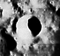
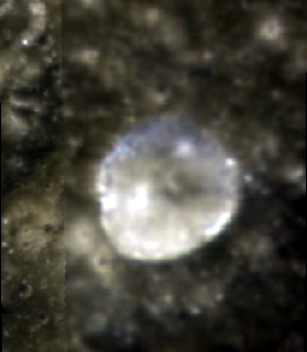
Left: LO4-137-h1, Right: Clementine
Images
LPOD Photo GalleryLunar Orbiter ImagesAdditional Lunar Orbiter Image (unlabeled - lower left)
Maps
Description
This is a bright simple crater that cuts into the rough rim of the Humorum Basin. The Clementine image shows a small enlargement of the SW rim due to a landslip of wall material to the floor. There is a small central peak, and apparently a later impact crater on the NE inner wall and another smaller one on the E rim, both revealed as bright dots.
  Chuck Wood - tychocrater Jun 17, 2007

  The following additional impressions are based on examination of a stereo image produced by combining LO-IV-136-H with LO-IV-137-H: Dunthorne appears to have formed atop an elevated landmass which sits astride a complicated series of steps and valleys descending from the higher level of Palus Epidemiarum on the south to the lower level of Mare Humorum on the north. The SW rim, where Chuck notes the landslip, butts up against what is presumably a pre-existing peak (visible in the LO4-137-h1 image reproduced above). It rises about 2000 m above the areas farther to the west (some 2-3 times the height of the crater rim). Diametrically opposite this (in the NE) there is a distinct low spot in the rim. In general, the south rim is distinctly higher than the north one (note the greater red fringing in the stereo image), but it too seems to have a low spot at about 5 o'clock. To the immediate east and west of Dunthorne, there are rough-bottomed valleys, winding from one level to the next, especially clear on the east. The area with the small shadowed crater to the north is a relatively flat-topped mesa. - JimMosher
Description: Elger
This crater seems to have been known as Ramsden A in Elger's day (see Neison Plate 14). The name Dunthorne appears as Collated List No. 2562 in Blagg and Muller's Named Lunar Features (1935).
Additional Information
- Depth information from Kurt Fisher compilation:
- Arthur (1974): 2.78 km
- Viscardy (1985): 2.78 km
- Westfall (2000): 2.78 km
- Selenodetic coordinates (Dunthorne is control point #762 in the 1994 and 2005 ULCN)
- 1994 Unified Lunar Control Network: 30.122 S/ 31.694 W; Elev: 1737.211 km
- Unified Lunar Control Network 2005: 30.1468 S/ 31.7346 W; Elev: 1737.245 km
- Note: ULCN elevations are measured from the Moon's center and presumably refer to the crater rim.
- Lunar Orbiter-IV measurements (LTVT):
- Depth (east rim-crest to floor):
- 2.62 km (LO-IV-079-H)
- 2.67 km (LO-IV-131-H)
- 2.91 km (LO-IV-136-H)
- 2.82 km (LO-IV-137-H)
- Rim height (above surroundings): to 800 m on west per LO-IV-131-H
- Best-fit diameter at rim-crest: 15.5 km (LO-IV-131-H)
- Note: the first two Lunar Orbiter depths are based on shadows from the east rim that extend beyond the center of the floor. Assuming a bowl shape, the depth at the center would be expected to be greater than the measurement. The second two results should be closer. The shadows in Consolidated Lunar Atlas photos with lighting from the east and west suggest the east rim is higher above the floor than the west rim. In those photos, the east as well as the west rim casts shadows outside the crater, indicating they both rise significantly above their surroundings (something confirmed by the stereo image).
- measured by - JimMosher
Nomenclature
Richard Dunthorne (1711--March 3, 1775) was a British amateur astronomer. Dunthorne studied the phenomenon of the speed of the Moon's orbit, published papers in the Philosophical Transactions, including On the motion of the Moon (1747), On the acceleration of the Moon (1749), and the letter Concerning comets in 1751. He also published a book of astronomical tables in 1739.
LPOD Articles
Bibliography