Difference between revisions of "Rimae Maupertuis"
(Created page with "<div id="content_view" class="wiki" style="display: block"> =Rimae Maupertuis= {| class="wiki_table" | Lat: 52.0°N, Long: 23.0°W, Length: 60 km, Depth: km, Rükl: 3<br />...") |
|||
| (2 intermediate revisions by the same user not shown) | |||
| Line 5: | Line 5: | ||
|} | |} | ||
<div id="toc"> | <div id="toc"> | ||
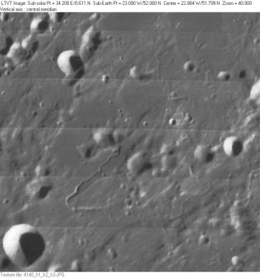
| − | + | [http://www.lpod.org/coppermine/albums/userpics/Rimae-Maupertuis_LO-IV-140H_LTVT.JPG [[Image:Normal_Rimae-Maupertuis_LO-IV-140H_LTVT.JPG|external image normal_Rimae-Maupertuis_LO-IV-140H_LTVT.JPG]]]<br /> ''[http://lpod.org/coppermine/displayimage.php?pos=-2903 LO-IV-140H]'' The IAU name '''Rimae Maupertuis''' presumably includes the two prominent sinuous rilles in the lower part of this view which includes 14-km '''[http://the-moon.us/wiki/Maupertuis Maupertuis] A''' (in the lower left) and 7-km '''Laplace L''' (at center right). The diameter given in the [http://the-moon.us/wiki/IAU%20Planetary%20Gazetteer IAU Planetary Gazetteer] is large enough to include 9-km '''[http://the-moon.us/wiki/La%20Condamine La Condamine] Q''' (to the upper left of center) and 6-km '''[http://the-moon.us/wiki/La%20Condamine La Condamine] P''' (which seems to be the upper end of the elongated depression to its upper right), so the name may include some of the other rille-like features as well.<br /> <br /> | |
| − | |||
==Images== | ==Images== | ||
[http://www.lpod.org/coppermine/thumbnails.php?album=search&type=full&search=Rimae%20Maupertuis LPOD Photo Gallery] [http://www.lpi.usra.edu/resources/lunar_orbiter/bin/srch_nam.shtml?Rimae%20Maupertuis%7C0 Lunar Orbiter Images]<br /> <br /> | [http://www.lpod.org/coppermine/thumbnails.php?album=search&type=full&search=Rimae%20Maupertuis LPOD Photo Gallery] [http://www.lpi.usra.edu/resources/lunar_orbiter/bin/srch_nam.shtml?Rimae%20Maupertuis%7C0 Lunar Orbiter Images]<br /> <br /> | ||
==Maps== | ==Maps== | ||
| − | ''([http://the-moon. | + | ''([http://the-moon.us/wiki/LAC%20zone LAC zone] 11C3)'' [http://www.lpi.usra.edu/resources/mapcatalog/LAC/lac11/ LAC map] [http://www.lpi.usra.edu/resources/mapcatalog/usgs/I604/ Geologic map]<br /> <br /> |
==Description== | ==Description== | ||
<br /> | <br /> | ||
| Line 18: | Line 17: | ||
<br /> | <br /> | ||
==Nomenclature== | ==Nomenclature== | ||
| − | - Named from nearby crater [http://the-moon. | + | - Named from nearby crater [http://the-moon.us/wiki/Maupertuis Maupertuis].<br /> - Numbers 131, 133, and 138 in Debra Hurwitz's Atlas and Catalog of Sinuous Rilles.<br /> - Not named on Chart 8 in the ''Times Atlas of the Moon''.<br /> <br /> |
==LPOD Articles== | ==LPOD Articles== | ||
<br /> | <br /> | ||
| Line 24: | Line 23: | ||
<br /> <br /> | <br /> <br /> | ||
---- | ---- | ||
| − | + | </div> | |
Latest revision as of 02:12, 16 April 2018
Contents
Rimae Maupertuis
| Lat: 52.0°N, Long: 23.0°W, Length: 60 km, Depth: km, Rükl: 3 |
LO-IV-140H The IAU name Rimae Maupertuis presumably includes the two prominent sinuous rilles in the lower part of this view which includes 14-km Maupertuis A (in the lower left) and 7-km Laplace L (at center right). The diameter given in the IAU Planetary Gazetteer is large enough to include 9-km La Condamine Q (to the upper left of center) and 6-km La Condamine P (which seems to be the upper end of the elongated depression to its upper right), so the name may include some of the other rille-like features as well.
Images
LPOD Photo Gallery Lunar Orbiter Images
Maps
(LAC zone 11C3) LAC map Geologic map
Description
Description: Wikipedia
Additional Information
Nomenclature
- Named from nearby crater Maupertuis.
  - Numbers 131, 133, and 138 in Debra Hurwitz's Atlas and Catalog of Sinuous Rilles.
  - Not named on Chart 8 in the Times Atlas of the Moon.
LPOD Articles
Bibliography
