Difference between revisions of "Index"
(Created page with "<div id="content_view" class="wiki" style="display: block"> =Index (Apollo 15 site craterlet name)= {| class="wiki_table" | Lat: 26.1°N, Long: 3.7°E, Diam: 0 km, Depth:...") |
|||
| (One intermediate revision by the same user not shown) | |||
| Line 3: | Line 3: | ||
{| class="wiki_table" | {| class="wiki_table" | ||
| | | | ||
| − | Lat: 26.1°N, Long: 3.7°E, Diam: 0 km, Depth: km, [ | + | Lat: 26.1°N, Long: 3.7°E, Diam: 0 km, Depth: km, [[R%C3%BCkl%2022|Rükl: 22]]<br /> |
|} | |} | ||
<div id="toc"> | <div id="toc"> | ||
| − | + | [[Image:Apollo_15_Index_crater.JPG|external image Apollo_15_Index_crater.JPG]]<br /> ''[http://www.lpi.usra.edu/resources/mapcatalog/LPST/41b4s4/ Apollo 15 Site Traverses Chart]''<br /> <br /> | |
| − | |||
==Images== | ==Images== | ||
[http://www.lpod.org/coppermine/thumbnails.php?album=search&type=full&search=Index LPOD Photo Gallery images] [http://www.lpi.usra.edu/resources/lunar_orbiter/bin/srch_nam.shtml?Index%7C0 Lunar Orbiter Images] [http://www.lpi.usra.edu/resources/apollo/search/feature/?feature=Index Apollo Images]<br /> <br /> | [http://www.lpod.org/coppermine/thumbnails.php?album=search&type=full&search=Index LPOD Photo Gallery images] [http://www.lpi.usra.edu/resources/lunar_orbiter/bin/srch_nam.shtml?Index%7C0 Lunar Orbiter Images] [http://www.lpi.usra.edu/resources/apollo/search/feature/?feature=Index Apollo Images]<br /> <br /> | ||
==Maps== | ==Maps== | ||
| − | ''([ | + | ''([[LAC%20zone|LAC zone]] 41B4)'' [http://www.lpi.usra.edu/resources/mapcatalog/LAC/lac41/ LAC map] [http://www.lpi.usra.edu/resources/mapcatalog/usgs/I463/ Geologic map] [http://www.lpi.usra.edu/resources/mapcatalog/LM/lm41/ LM map] [http://www.lpi.usra.edu/resources/mapcatalog/LTO/lto41b4_2/ LTO map] [http://www.lpi.usra.edu/resources/mapcatalog/topophoto/41B4S1/ Topophotomap]<br /> <br /> |
==Description== | ==Description== | ||
A prominent crater near the landing site that served as the major landmark for orbital tracking and for LM descent. It is old enough that its original sharp rim morphology has been eroded down.<br /> <br /> | A prominent crater near the landing site that served as the major landmark for orbital tracking and for LM descent. It is old enough that its original sharp rim morphology has been eroded down.<br /> <br /> | ||
| Line 17: | Line 16: | ||
[http://en.wikipedia.org/wiki/Apollo_15%2C_Lunar_surface#Landing Index] (not really a page for craterlet '''Index''', it's an overview of the surface activities of Apollo 15, quite an interesting page!).<br /> <br /> | [http://en.wikipedia.org/wiki/Apollo_15%2C_Lunar_surface#Landing Index] (not really a page for craterlet '''Index''', it's an overview of the surface activities of Apollo 15, quite an interesting page!).<br /> <br /> | ||
==Additional Information== | ==Additional Information== | ||
| − | The [ | + | The [[Landing%20Site%20Name|Landing Site Name]] "Index" is plotted on [http://www.lpi.usra.edu/resources/mapcatalog/topophoto/41B4S1/ Topophotomap 41B4/S1] .<br /> <br /> |
==Nomenclature== | ==Nomenclature== | ||
| − | Astronaut-named feature, [ | + | Astronaut-named feature, [[Apollo%2015%20site|Apollo 15 site]].<br /> The naming of that craterlet ('''Index''') seems to have been a complicated happening! (see Wikipedia page mentioned above).<br /> <br /> |
==LPOD Articles== | ==LPOD Articles== | ||
<br /> | <br /> | ||
| Line 25: | Line 24: | ||
Kenneth F. Weaver''':''' ''Apollo 15 explores the mountains of the moon'' (National Geographic, February 1972).<br /> David M. Harland''':''' ''EXPLORING THE MOON; The Apollo Expeditions.''<br /> Eric M. Jones''':''' ''APOLLO LUNAR SURFACE JOURNAL (ALSJ).''<br /> | Kenneth F. Weaver''':''' ''Apollo 15 explores the mountains of the moon'' (National Geographic, February 1972).<br /> David M. Harland''':''' ''EXPLORING THE MOON; The Apollo Expeditions.''<br /> Eric M. Jones''':''' ''APOLLO LUNAR SURFACE JOURNAL (ALSJ).''<br /> | ||
---- | ---- | ||
| − | + | </div> | |
Latest revision as of 16:27, 15 April 2018
Contents
Index (Apollo 15 site craterlet name)
|
Lat: 26.1°N, Long: 3.7°E, Diam: 0 km, Depth: km, Rükl: 22 |
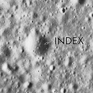
Apollo 15 Site Traverses Chart
Images
LPOD Photo Gallery images Lunar Orbiter Images Apollo Images
Maps
(LAC zone 41B4) LAC map Geologic map LM map LTO map Topophotomap
Description
A prominent crater near the landing site that served as the major landmark for orbital tracking and for LM descent. It is old enough that its original sharp rim morphology has been eroded down.
Description: Wikipedia
Index (not really a page for craterlet Index, it's an overview of the surface activities of Apollo 15, quite an interesting page!).
Additional Information
The Landing Site Name "Index" is plotted on Topophotomap 41B4/S1 .
Nomenclature
Astronaut-named feature, Apollo 15 site.
  The naming of that craterlet (Index) seems to have been a complicated happening! (see Wikipedia page mentioned above).
LPOD Articles
Bibliography
Kenneth F. Weaver: Apollo 15 explores the mountains of the moon (National Geographic, February 1972).
  David M. Harland: EXPLORING THE MOON; The Apollo Expeditions.
  Eric M. Jones: APOLLO LUNAR SURFACE JOURNAL (ALSJ).
