Difference between revisions of "Billy"
| Line 3: | Line 3: | ||
{| class="wiki_table" | {| class="wiki_table" | ||
| colspan="2" | | | colspan="2" | | ||
| − | Lat: 13.8°S, Long: 50.1°W, Diam: 45 km, Depth: 1.29 km, [ | + | Lat: 13.8°S, Long: 50.1°W, Diam: 45 km, Depth: 1.29 km, [[R%C3%BCkl%2040|Rükl: 40]]<br /> |
|- | |- | ||
| | | | ||
| Line 16: | Line 16: | ||
[http://www.lpod.org/coppermine/thumbnails.php?album=search&type=full&search=Billy LPOD Photo Gallery] [http://www.lpi.usra.edu/resources/lunar_orbiter/bin/srch_nam.shtml?Billy%7C0 Lunar Orbiter Images] [http://www.lpi.usra.edu/resources/apollo/search/feature/?feature=Billy Apollo Images]<br /> <br /> | [http://www.lpod.org/coppermine/thumbnails.php?album=search&type=full&search=Billy LPOD Photo Gallery] [http://www.lpi.usra.edu/resources/lunar_orbiter/bin/srch_nam.shtml?Billy%7C0 Lunar Orbiter Images] [http://www.lpi.usra.edu/resources/apollo/search/feature/?feature=Billy Apollo Images]<br /> <br /> | ||
==Maps== | ==Maps== | ||
| − | ''([ | + | ''([[LAC%20zone|LAC zone]] 74C3)'' [http://www.lpi.usra.edu/resources/mapcatalog/LAC/lac74/ LAC map] [http://www.lpi.usra.edu/resources/mapcatalog/usgs/I740/ Geologic map]<br /> <br /> |
==Description== | ==Description== | ||
<br /> | <br /> | ||
==Description: Elger== | ==Description: Elger== | ||
| − | ''([ | + | ''([[IAU%20Directions|IAU Directions]])'' BILLY.--A ring-plain, 31 miles in diameter, S.W. of [[Letronne|Letronne]], with a very dark floor, depressed about 1,000 feet below the grey surface on the E., and a regular border, rising more than 3,000 feet above it. There is a narrow gap on the S., and indications of a crater on the N.E. rim. Two small craters stand on the S. half of the interior. The formation is flanked on the S.E. by highlands.<br /> <br /> |
==Description: Wikipedia== | ==Description: Wikipedia== | ||
[http://en.wikipedia.org/wiki/Billy_(crater) Billy]<br /> <br /> | [http://en.wikipedia.org/wiki/Billy_(crater) Billy]<br /> <br /> | ||
==Additional Information== | ==Additional Information== | ||
| − | Depth data from [ | + | Depth data from [[Kurt%20Fisher%20crater%20depths|Kurt Fisher database]]<br /> |
* Westfall, 2000: 1.29 km | * Westfall, 2000: 1.29 km | ||
* Viscardy, 1985: 1.21 km | * Viscardy, 1985: 1.21 km | ||
Revision as of 14:41, 15 April 2018
Contents
Billy
|
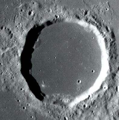
Lat: 13.8°S, Long: 50.1°W, Diam: 45 km, Depth: 1.29 km, Rükl: 40 | |
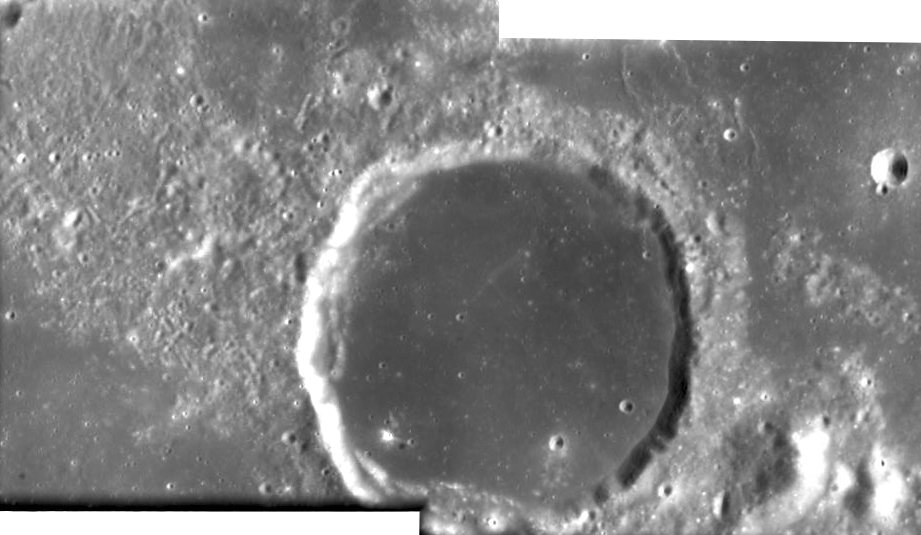
Right: SMART-1
Table of Contents
Images
LPOD Photo Gallery Lunar Orbiter Images Apollo Images
Maps
(LAC zone 74C3) LAC map Geologic map
Description
Description: Elger
(IAU Directions) BILLY.--A ring-plain, 31 miles in diameter, S.W. of Letronne, with a very dark floor, depressed about 1,000 feet below the grey surface on the E., and a regular border, rising more than 3,000 feet above it. There is a narrow gap on the S., and indications of a crater on the N.E. rim. Two small craters stand on the S. half of the interior. The formation is flanked on the S.E. by highlands.
Description: Wikipedia
Additional Information
Depth data from Kurt Fisher database
- Westfall, 2000: 1.29 km
- Viscardy, 1985: 1.21 km
- Cherrington, 1969: 1.21 km
Nomenclature
Jacques de Billy (March 18, 1602 – January 14, 1679) was a French Jesuit mathematician. Billy produced a number of results in number theory which have been named after him. He published several astronomical tables and was one of the first scientists to reject the role of astrology in science. He also rejected old notions about the malevolent influence of comets.
LPOD Articles
Bibliography
This page has been edited 1 times. The last modification was made by - tychocrater tychocrater on Jun 13, 2009 3:24 pm - afx2u2

