Difference between revisions of "Planitia Descensus"
(Created page with "<div id="content_view" class="wiki" style="display: block"> =Planitia Descensus (landingsite of Luna 9)= {| class="wiki_table" | Lat: 7.1°N, Long: 64.4°W, Diam: 0 km, De...") |
|||
| Line 29: | Line 29: | ||
* Luna 9 landing site ("plain of descent"). | * Luna 9 landing site ("plain of descent"). | ||
| − | * Called '''''Sinus Adlunationis''''' on the [http://the-moon. | + | * Called '''''Sinus Adlunationis''''' on the [http://the-moon.us/wiki/Sternberg%20lunar%20nomenclature Complete Moon Map of 1969 by the Sternberg Astronomy Institute]. Research: Danny Caes |
<br /> | <br /> | ||
==LPOD Articles== | ==LPOD Articles== | ||
Revision as of 19:27, 11 April 2018
Contents
Planitia Descensus (landingsite of Luna 9)
|
Lat: 7.1°N, Long: 64.4°W, Diam: 0 km, Depth: km, [/R%C3%BCkl%2028 Rükl: 28] |
Table of Contents
[#Planitia Descensus (landingsite of Luna 9) Planitia Descensus (landingsite of Luna 9)]
[#Planitia Descensus (landingsite of Luna 9)-Images Images]
[#Planitia Descensus (landingsite of Luna 9)-Maps Maps]
[#Planitia Descensus (landingsite of Luna 9)-Description Description]
[#Planitia Descensus (landingsite of Luna 9)-Description: Wikipedia Description: Wikipedia]
[#Planitia Descensus (landingsite of Luna 9)-Additional Information Additional Information]
[#Planitia Descensus (landingsite of Luna 9)-Nomenclature Nomenclature]
[#Planitia Descensus (landingsite of Luna 9)-LPOD Articles LPOD Articles]
[#Planitia Descensus (landingsite of Luna 9)-Bibliography Bibliography]

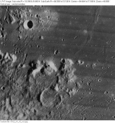
LO-IV-162H The crater in the upper left is [/Cavalerius Cavalerius] F.
Images
LPOD Photo Gallery Lunar Orbiter Images
- Frame 3214, made by Lunar Orbiter 3, shows an oblique view of Planitia Descensus and crater Galilaei in the distance.
- Apollo 17's NIKON-camera photographs AS17-158-23895 and 23896 show Planitia Descensus near the upper margins of both frames (made in earthlight circumstances).
- Research Lunar Orbiter 3 and Apollo 17 photography: Danny Caes
Maps
([/LAC%20zone LAC zone] 56D2) LAC map Geologic map
Description
This IAU name commemorates the February 3, 1966 landing site of Luna 9, the first spacecraft from Earth to successfully soft-land on the Moon and return images from it. In the [/Lunar%20Orbiter Lunar Orbiter] image shown here, the official [/IAU%20Nomenclature IAU coordinates] are marked by a white cross on the peak to the right of center, but the actual landing was in a mare area. Many charts place the Luna 9 landing site in the plain immediately to the left of the cross. However [/NASA%20SP-241 NASA SP-241], which may be more definitive, places it to the right, almost touching the left side of the bright crescent. The position shown in SP-241 is approximately 7.19°N, 64.18°W

  Although [/Planitia Planitia] means "plain" the name is thought to refer, like [/Apollo%2011%20Site Statio Tranquillitatis], to the landing site only, a feature of zero size, and not to the surrounding region.

 - JimMosher JimMosher
Description: Wikipedia
Additional Information
- Luna 9 was the first mission to establish that the lunar surface (at least at that point) could bear the weight of a spacecraft.
- Robert Christy gives the landing site coordinates as 7.13 degrees north, 60.36 degrees west (the latter, giving a location near [/Reiner%20Gamma Reiner Gamma], is almost certainly a typo).
- John Walker gives the landing site coordinates as 7.08 degrees north, 64.37 degrees west (a position on the peak, very close to the cross).
Nomenclature
- Luna 9 landing site ("plain of descent").
- Called Sinus Adlunationis on the Complete Moon Map of 1969 by the Sternberg Astronomy Institute. Research: Danny Caes
LPOD Articles
Bibliography
- Jaffe, L. D.; Scott, R. F. 1966 Lunar Surface Strength: Implications of Luna 9 Landing SCIENCE vol. 153, 407-408.
This page has been edited 1 times. The last modification was made by - tychocrater tychocrater on Jun 13, 2009 3:24 pm - afx3u2