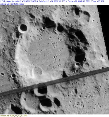
Difference between revisions of "Manzinus"
(Created page with "<div id="content_view" class="wiki" style="display: block"> =Manzinus= {| class="wiki_table" | Lat: 67.7°S, Long: 26.8°E, Diam: 98 km, Depth: 5 km, Rükl: 74<br /> |} <...") |
|||
| Line 30: | Line 30: | ||
<br /> | <br /> | ||
==LPOD Articles== | ==LPOD Articles== | ||
| − | [http:// | + | [http://www2.lpod.org/wiki/July_13,_2004 A Strange Depression]<br /> [http://www2.lpod.org/wiki/October_4,_2006 A Second Discovery]<br /> <br /> |
==Bibliography== | ==Bibliography== | ||
<br /> <br /> | <br /> <br /> | ||
---- | ---- | ||
This page has been edited 1 times. The last modification was made by <span class="membersnap">- [http://www.wikispaces.com/user/view/tychocrater [[Image:tychocrater-lg.jpg|16px|tychocrater]]] [http://www.wikispaces.com/user/view/tychocrater tychocrater]</span> on Jun 13, 2009 3:24 pm - ''afx3u2''</div> | This page has been edited 1 times. The last modification was made by <span class="membersnap">- [http://www.wikispaces.com/user/view/tychocrater [[Image:tychocrater-lg.jpg|16px|tychocrater]]] [http://www.wikispaces.com/user/view/tychocrater tychocrater]</span> on Jun 13, 2009 3:24 pm - ''afx3u2''</div> | ||
Revision as of 19:23, 11 April 2018
Contents
Manzinus
| Lat: 67.7°S, Long: 26.8°E, Diam: 98 km, Depth: 5 km, Rükl: 74 |
Table of Contents
[#Manzinus Manzinus]
[#Manzinus-Images Images]
[#Manzinus-Maps Maps]
[#Manzinus-Description Description]
[#Manzinus-Description: Elger Description: Elger]
[#Manzinus-Description: Wikipedia Description: Wikipedia]
[#Manzinus-Additional Information Additional Information]
[#Manzinus-Nomenclature Nomenclature]
[#Manzinus-LPOD Articles LPOD Articles]
[#Manzinus-Bibliography Bibliography]

LO-IV-094H
Images
LPOD Photo Gallery Lunar Orbiter Images
- Although it is not mentioned in the LPI's search-list of orbital Apollo photographs, the crater called Manzinus WAS photographed during the mission of Apollo 15. It was captured at the lower central part of frame AS15-95-12988.
- Research: Danny Caes.
Maps
([/LAC%20zone LAC zone] 138A2) USGS Digital Atlas PDF
Description
Description: Elger
([/IAU%20Directions IAU Directions]) MANZINUS.--A walled plain, nearly 62 miles in diameter, with a terraced rampart rising to a height of more than 14,500 feet above the interior. Schmidt shows three craterlets on the floor, but no traces of the small central peak which is said to stand thereon, but to be only visible in large telescopes.
Description: Wikipedia
Additional Information
- Depth data from [/Kurt%20Fisher%20crater%20depths Kurt Fisher database]
- Westfall, 2000: 5 km
- Viscardy, 1985: 3.5 km
- Cherrington, 1969: 2.98 km
- Satellite crater Manzinus E is [/radar%20bright radar bright] at 70 cm.
Nomenclature
- Conte Carlo Antonio Manzini (1599-1677) was an Italian astronomer and mathematician. His 1660 work, L'occhiale all'occhio, dioptrica practica, is one of the oldest accounts of the techniques for manufacturing lenses through grinding and polishing.
- Named by Riccioli (1651)
LPOD Articles
A Strange Depression
A Second Discovery
Bibliography
This page has been edited 1 times. The last modification was made by - tychocrater tychocrater on Jun 13, 2009 3:24 pm - afx3u2