Difference between revisions of "Heraclitus"
(Created page with "<div id="content_view" class="wiki" style="display: block"> =Heraclitus= {| class="wiki_table" | Lat: 49.2°S, Long: 6.2°E, Diam: 90 km, Depth: 4.26 km, [/R%C3%BCkl%2073...") |
|||
| Line 35: | Line 35: | ||
<br /> | <br /> | ||
==LPOD Articles== | ==LPOD Articles== | ||
| − | [http:// | + | [http://www2.lpod.org/wiki/April_16,_2005 Ridgeback Crater]<br /> <br /> |
==Bibliography== | ==Bibliography== | ||
A Portfolio of Lunar Drawings (Harold Hill), pages 184, 185.<br /> <br /> | A Portfolio of Lunar Drawings (Harold Hill), pages 184, 185.<br /> <br /> | ||
---- | ---- | ||
This page has been edited 1 times. The last modification was made by <span class="membersnap">- [http://www.wikispaces.com/user/view/tychocrater [[Image:tychocrater-lg.jpg|16px|tychocrater]]] [http://www.wikispaces.com/user/view/tychocrater tychocrater]</span> on Jun 13, 2009 3:24 pm - ''afx3u2''</div> | This page has been edited 1 times. The last modification was made by <span class="membersnap">- [http://www.wikispaces.com/user/view/tychocrater [[Image:tychocrater-lg.jpg|16px|tychocrater]]] [http://www.wikispaces.com/user/view/tychocrater tychocrater]</span> on Jun 13, 2009 3:24 pm - ''afx3u2''</div> | ||
Revision as of 19:16, 11 April 2018
Contents
Heraclitus
|
Lat: 49.2°S, Long: 6.2°E, Diam: 90 km, Depth: 4.26 km, [/R%C3%BCkl%2073 Rükl: 73] |
Table of Contents
[#Heraclitus Heraclitus]
[#Heraclitus-Images Images]
[#Heraclitus-Maps Maps]
[#Heraclitus-Description Description]
[#Heraclitus-Description: Wikipedia Description: Wikipedia]
[#Heraclitus-Additional Information Additional Information]
[#Heraclitus-Nomenclature Nomenclature]
[#Heraclitus-LPOD Articles LPOD Articles]
[#Heraclitus-Bibliography Bibliography]

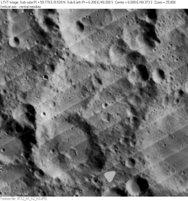
LO-IV-112H Heraclitus is in the center. Above it is the southern half of 74-km [/Licetus Licetus]. In the southwest, Heraclitus is overlain by 52-km Heraclitus D, and partially visible in the lower right is 75-km [/Cuvier Cuvier]. Many of the smaller features in this view are named as [/satellite%20feature lettered craters].
Images
LPOD Photo Gallery Lunar Orbiter Images Apollo Images
Maps
([/LAC%20zone LAC zone] 126B2) LAC map Geologic map
Description
Description: Wikipedia
Additional Information
Depth data from [/Kurt%20Fisher%20crater%20depths Kurt Fisher database]
- Westfall, 2000: 4.26 km
- Viscardy, 1985: 3.8 km
- Cherrington, 1969: 2.89 km
- According to measurements made using the ILIADS’s software, the highest part of the crater’s rim on the east (and northwest) reaches, on average, some 1.4 km approx., above the mean radius of the Moon (~ 1738 km). Measurements of the crater’s floor, on average, reaches some 1.9 km approx., below the mean radius. Together, this would imply the depth of the crater, on average, is at around the 3.3 km mark (1.4 km + 1.9 km = 3.3 km) - from these respective points. Sub-crater, Heraclitus D (which has impacted Heraclitus’s southwest sector), is some 2.9 km approx., below the mean radius, increasing its depth, from the highest part of the rim to about 4.3 km (1.4 + 2.9 km = 4.3 km). - JohnMoore2 JohnMoore2
- Ridge or Peak
ILIADS (above-mentioned) measures the ridge?/peak? (the feature that divides the crater’s floor in a NE-SW direction), on average, at some 0.6 km below the mean radius of the Moon (~ 1738 km). Given that the depth is some 3.3 km (in relation to the Illiads’s measurements – see Depth data above), the height of the ‘ridge?/peak? is around the 1.3 km mark [(3.3 km) – (1.4 km + 0.6 km = 2.0 km) = 1.3 km)]. - JohnMoore2 JohnMoore2
Nomenclature
- Named for Heraclitus of Ephesus (ca. 535–475 BCE), known as "The Obscure", a pre-Socratic Greek philosopher. Heraclitus was the first person in the Western world to create a robust philosophical system. His writings influenced the thought of Socrates, Plato, and modern process philosophy.
- This feature is Catalog number 3416 in Mary Blagg's [/Collated%20List Collated List]. A note (page 175) indicates the name was given by Schmidt to what in [/Beer%20and%20M%C3%A4dler Beer and Mädler] and [/Neison%2C%201876 Neison, 1876] was a compound feature called [/Licetus Licetus]. Schmidt restricted that name to their Licetus a, assigning the present name to their Licetus c.
- Schmidt's name was adopted in [/Named%20Lunar%20Formations Named Lunar Formations] (1935) where five [/satellite%20features satellite features] (A-E share the primary name.
- Kuiper reports in [/PLA%20Table%20III Table III] of his [/Photographic%20Lunar%20Atlas Photographic Lunar Atlas] (approved by the IAU) that he has modified the IAU boundary of this feature: Now includes I.A.U. Heraclitus B.
- The original Heraclitus was the western part of the presently-named feature. Heraclitus B (a name no longer used) was the overlapping and similarly-sized eastern part, presumably separated by the spine down the center.
- A Heraclitus K was added in the [/System%20of%20Lunar%20Craters System of Lunar Craters].
LPOD Articles
Bibliography
A Portfolio of Lunar Drawings (Harold Hill), pages 184, 185.
This page has been edited 1 times. The last modification was made by - tychocrater tychocrater on Jun 13, 2009 3:24 pm - afx3u2