Difference between revisions of "Alpine Valley Central Rille"
(Created page with "<div id="content_view" class="wiki" style="display: block"> =Alpine Valley Central Rille= {| class="wiki_table" | Lat: 48.5°N, Long: 3.2°E, Length: 142 km, Width: 0.75 k...") |
|||
| Line 24: | Line 24: | ||
Number 129 in Debra Hurwitz's Atlas and Catalog of Sinuous Rilles.<br /> <br /> | Number 129 in Debra Hurwitz's Atlas and Catalog of Sinuous Rilles.<br /> <br /> | ||
==LPOD Articles== | ==LPOD Articles== | ||
| − | [http:// | + | [http://www2.lpod.org/wiki/October_20,_2006 A Gash and a River]<br /> [http://www2.lpod.org/wiki/August_1,_2006 Schroeter & Pickering & Keene]<br /> [http://www2.lpod.org/wiki/April_11,_2004 Valley of the Alpes]<br /> [http://lpod.wikispaces.com/April%2015%2C%202009 A River Ran Through It]<br /> <br /> |
==Bibliography== | ==Bibliography== | ||
<br /> <br /> | <br /> <br /> | ||
---- | ---- | ||
This page has been edited 1 times. The last modification was made by <span class="membersnap">- [http://www.wikispaces.com/user/view/tychocrater [[Image:tychocrater-lg.jpg|16px|tychocrater]]] [http://www.wikispaces.com/user/view/tychocrater tychocrater]</span> on Jun 13, 2009 3:24 pm - ''afx4''</div> | This page has been edited 1 times. The last modification was made by <span class="membersnap">- [http://www.wikispaces.com/user/view/tychocrater [[Image:tychocrater-lg.jpg|16px|tychocrater]]] [http://www.wikispaces.com/user/view/tychocrater tychocrater]</span> on Jun 13, 2009 3:24 pm - ''afx4''</div> | ||
Revision as of 19:08, 11 April 2018
Contents
Alpine Valley Central Rille
|
Lat: 48.5°N, Long: 3.2°E, Length: 142 km, Width: 0.75 km Depth: 0.14 km, [/R%C3%BCkl%2012 Rükl: 12] |

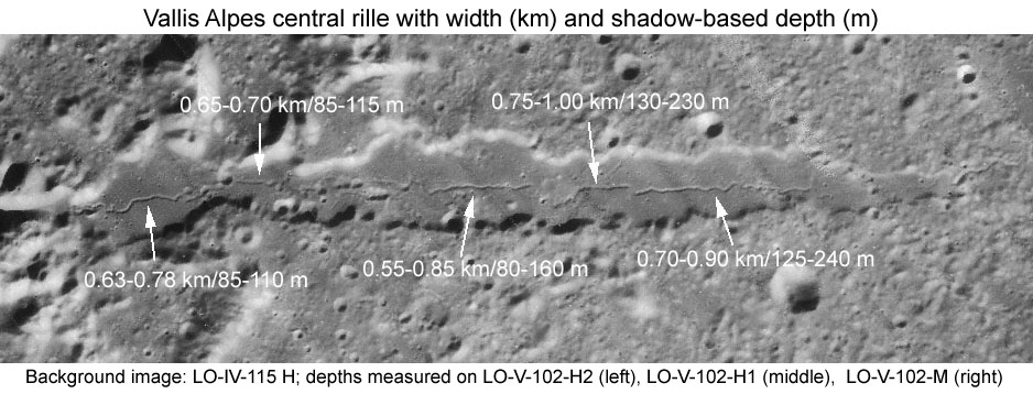
LPOD Photo Gallery The image indicates the width and depth (as measured by [/LTVT LTVT] of the rille that is visible down the middle of most of [/Vallis%20Alpes Vallis Alpes] (formerly known as the Alpine Valley). Links to higher resolution versions of the Lunar Orbiter images can be found on the LPI website: LO-IV-115 and LO-V-102.
Table of Contents
[#Alpine Valley Central Rille Alpine Valley Central Rille]
[#Alpine Valley Central Rille-Images Images]
[#Alpine Valley Central Rille-Maps Maps]
[#Alpine Valley Central Rille-Description Description]
[#Alpine Valley Central Rille-Description: Wikipedia Description: Wikipedia]
[#Alpine Valley Central Rille-Additional Information Additional Information]
[#Alpine Valley Central Rille-Nomenclature Nomenclature]
[#Alpine Valley Central Rille-LPOD Articles LPOD Articles]
[#Alpine Valley Central Rille-Bibliography Bibliography]
Images
LPOD Photo Gallery Lunar Orbiter Images Apollo Images
Maps
([/LAC%20zone LAC zone] 12C3) LAC map Geologic map
Description
Attempting to detect this relatively narrow sinuous [/rima rille] is a favorite challenge of amateur observers of the Moon, yet accurate dimensions do not see to have been published. The above image gives measurements made with the freeware [/LTVT Lunar Terminator Visualization Tool] on images returned in the 1960's by [/Lunar%20Orbiter Lunar Orbiter V]. The average of the ten width estimates is 750 m with a standard deviation of 130 m. The average of the ten depth estimates is 140 m with a standard deviation of 60 m. - JimMosher JimMosher
Description: Wikipedia
Additional Information
- The fact that the image upon which the present measurements are based is slightly oblique adds some slight additional uncertainty to the measurements.
- The length given is from where the rille starts in what Elger called the "Florence flask" bottle on the far left, to where the narrow part peters out on the far right. No correction was made for the possible breaks in the rille between these two points. - JimMosher JimMosher
- Because the depths given are based on shadows, and the shadows may not reach fully to the bottom of the rille, they should be regarded as limits on the true depth. But they are probably not far off. - JimMosher JimMosher
Nomenclature
Number 129 in Debra Hurwitz's Atlas and Catalog of Sinuous Rilles.
LPOD Articles
A Gash and a River
Schroeter & Pickering & Keene
Valley of the Alpes
A River Ran Through It
Bibliography
This page has been edited 1 times. The last modification was made by - tychocrater tychocrater on Jun 13, 2009 3:24 pm - afx4