Difference between revisions of "West"
(Created page with "<div id="content_view" class="wiki" style="display: block"> =West (Apollo 11 site craterlet name)= {| class="wiki_table" | Lat: 0.8°N, Long: 23.5°E, Diam: 0.18 km, Depth...") |
|||
| (3 intermediate revisions by the same user not shown) | |||
| Line 3: | Line 3: | ||
{| class="wiki_table" | {| class="wiki_table" | ||
| | | | ||
| − | Lat: 0.8°N, Long: 23.5°E, Diam: 0.18 km, Depth: 0.03 km, [ | + | Lat: 0.8°N, Long: 23.5°E, Diam: 0.18 km, Depth: 0.03 km, [[R%C3%BCkl%2035|Rükl: 35]]<br /> |
|} | |} | ||
<div id="toc"> | <div id="toc"> | ||
| − | + | [http://www.lpod.org/coppermine/albums/userpics/Apollo_11_Area_LO-V-076M_LTVT.JPG [[Image:Normal_Apollo_11_Area_LO-V-076M_LTVT.JPG|external image normal_Apollo_11_Area_LO-V-076M_LTVT.JPG]]][http://www.lpod.org/coppermine/albums/userpics/Apollo_11_Site_LO-V-076H_LTVT.JPG [[Image:Normal_Apollo_11_Site_LO-V-076H_LTVT.JPG|external image normal_Apollo_11_Site_LO-V-076H_LTVT.JPG]]]<br /> ''Left: [http://lpod.org/coppermine/displayimage.php?pos=-2205 LO-V-076M]; Right: [http://lpod.org/coppermine/displayimage.php?pos=-2204 LO-V-076H]''<br /> <br /> The view on the left, taken by the medium resolution camera onboard [[Lunar%20Orbiter|Lunar Orbiter]] V, shows the location of the IAU-named crater '''West''' in relation to [[Collins|Collins]] and the [http://www.hq.nasa.gov/alsj/a11/apollo11site2.jpg informally named] "'''Cat's Paw'''", both of which can, when conditions are just right, be seen though amateur telescopes from Earth. The pair of roughly 1-km diameter craters to the east of the "'''Cat's Paw'''" can also be barely seen on the best amateur photos.<br /> <br /> The view on the right, taken at the same instant with Lunar Orbiter V's high resolution camera, shows '''West''' in more detail. The crater names "'''Double'''" and "'''Little West'''" are informal names that appear on the [http://www.lpi.usra.edu/resources/mapcatalog/LPST/ap_11_12_14/ Site Traverses Map] of the Apollo 11 Landing Site. In its [http://www.hq.nasa.gov/alsj/a11/a11mrf5-08.gif final approach] (coming in from the right), the lunar module flew just north of '''West''', passing directly over "'''Little West'''" (called "'''East'''" on some NASA maps), and finally touching down just short of "'''Double'''" crater. Some parts of the rims of the "'''Cat's Paw'''" craters can [http://www.hq.nasa.gov/alsj/a11/images11.html reportedly] be seen from this location.<br /> <br /> | |
| − | |||
==Images== | ==Images== | ||
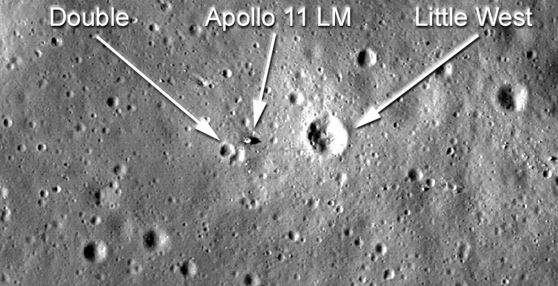
| − | [http://www.lpod.org/coppermine/thumbnails.php?album=search&type=full&search=West LPOD Photo Gallery] [http://www.lpi.usra.edu/resources/lunar_orbiter/bin/srch_nam.shtml?West%7C0 Lunar Orbiter Images] [http://www.lpi.usra.edu/resources/apollo/search/feature/?feature=West Apollo Images]<br /> Is craterlet '''West''' visible on Apollo 11's LEVA photographs made by Neil Armstrong? (photographs made while Edwin Aldrin descended LM ''Eagle'''s ladder) (something of a shadowed eastern inner slope of a crater is visible in the distance, looking eastward under the LM's Descent Stage, sans the disturbing glare of the morning sun's light). <span class="membersnap">- | + | [http://www.lpod.org/coppermine/thumbnails.php?album=search&type=full&search=West LPOD Photo Gallery] [http://www.lpi.usra.edu/resources/lunar_orbiter/bin/srch_nam.shtml?West%7C0 Lunar Orbiter Images] [http://www.lpi.usra.edu/resources/apollo/search/feature/?feature=West Apollo Images]<br /> Is craterlet '''West''' visible on Apollo 11's LEVA photographs made by Neil Armstrong? (photographs made while Edwin Aldrin descended LM ''Eagle'''s ladder) (something of a shadowed eastern inner slope of a crater is visible in the distance, looking eastward under the LM's Descent Stage, sans the disturbing glare of the morning sun's light). <span class="membersnap">- DannyCaes <small>Oct 18, 2015</small></span><br /> [[Image:LittleWest-Double.jpg|LittleWest-Double.jpg]]<br /> <span class="membersnap">- JohnMoore2</span><br /> <br /> |
==Maps== | ==Maps== | ||
| − | ''([ | + | ''([[LAC%20zone|LAC zone]] 60C4)'' [http://www.lpi.usra.edu/resources/mapcatalog/LAC/lac60/ LAC map] [http://www.lpi.usra.edu/resources/mapcatalog/usgs/I510/ Geologic map] [http://www.lpi.usra.edu/resources/mapcatalog/LM/lm60/ LM map] [http://www.lpi.usra.edu/resources/mapcatalog/AIC/AIC60C/ AIC map] [http://www.lpi.usra.edu/resources/mapcatalog/LPST/ap_11_12_14/ Site Traverses Map]<br /> <br /> |
==Description== | ==Description== | ||
<br /> | <br /> | ||
| Line 17: | Line 16: | ||
<br /> | <br /> | ||
==Additional Information== | ==Additional Information== | ||
| − | * '''West''' is about 185 m in diameter and, according to the primary shadow in LO-V-076H, is about 30 m deep. The central peak, casting a tiny secondary shadow, is about 7 m tall. The official IAU diameter is "O km", a common notation for a [ | + | * '''West''' is about 185 m in diameter and, according to the primary shadow in LO-V-076H, is about 30 m deep. The central peak, casting a tiny secondary shadow, is about 7 m tall. The official IAU diameter is "O km", a common notation for a [[Landing%20Site%20Name|Landing Site Name]]. |
| − | * In the coordinate system used to calibrate these [ | + | * In the coordinate system used to calibrate these [[LTVT|LTVT]] versions of the Lunar Orbiter images, the Apollo 11 Lunar Ranging Retroreflector (LRRR), placed just outside the SE rim of the "'''Double'''" crater, is at 0.697°N, 23.444°E. The [[ULCN#Fundamental_points|true coordinates]] of the LRRR in the Mean Earth/Polar coordinates system are 0.67337°N, 23.47293°E. Hence the positions given at the top of the LTVT images need to be shifted by about 0.03 degrees (or about 1 km on the lunar surface). Locating points on the Moon to this precision is surprisingly difficult because of the lack of well-determined reference points. In fact, during its brief stay on the Moon, the Apollo 11 mission controllers were unable to give Command Module pilot Michael Collins sufficiently accurate coordinates for him to find the landing craft visually by reference to previously-established features. The idea that this particular LTVT calibration needs to be corrected by about 0.03 degrees is quite consistent with the offset observed at the independently-determined Apollo Landmark Tracking point near [[Collins|Collins]]. <span class="membersnap">- JimMosher</span> |
| − | * It had been suggested that '''West''' crater might have been named for [http://www.memorialspaceflights.com/memorial/explorers/west.asp Mareta N. West], a geologist who worked on NASA's Geology Experiment Team during the Apollo 11 mission. It was discovered that West may have been the first to suggest that '''West''' crater was the crater that Armstrong had dodged during landing and possibly even on landing day based on the crews description of the approach and of the landing site. Further investigation, however, stongly suggested that the crater had in fact been named prior to the mission for its location in the western part of the Apollo 11 landing ellipse and any connection with Mareta West was a coincidence. This investigation was initiated by Apollo Lunar Surface Journal editor Eric Jones and included a discussion and some research by Ewen Whitaker of the ''Lunar and Planetary Laboratory'' after discussions with the current contributor. <span class="membersnap">- | + | * It had been suggested that '''West''' crater might have been named for [http://www.memorialspaceflights.com/memorial/explorers/west.asp Mareta N. West], a geologist who worked on NASA's Geology Experiment Team during the Apollo 11 mission. It was discovered that West may have been the first to suggest that '''West''' crater was the crater that Armstrong had dodged during landing and possibly even on landing day based on the crews description of the approach and of the landing site. Further investigation, however, stongly suggested that the crater had in fact been named prior to the mission for its location in the western part of the Apollo 11 landing ellipse and any connection with Mareta West was a coincidence. This investigation was initiated by Apollo Lunar Surface Journal editor Eric Jones and included a discussion and some research by Ewen Whitaker of the ''Lunar and Planetary Laboratory'' after discussions with the current contributor. <span class="membersnap">- jscotti</span> |
<br /> | <br /> | ||
==Nomenclature== | ==Nomenclature== | ||
| − | * Little West was officially approved by the IAU on the 26 July 2017 <span class="membersnap">- | + | * Little West was officially approved by the IAU on the 26 July 2017 <span class="membersnap">- JohnMoore2</span> |
| − | * IAU Official pages ([https://planetarynames.wr.usgs.gov/Feature/15615 Little West] and [https://planetarynames.wr.usgs.gov/Feature/15616 Double]) <span class="membersnap">- | + | * IAU Official pages ([https://planetarynames.wr.usgs.gov/Feature/15615 Little West] and [https://planetarynames.wr.usgs.gov/Feature/15616 Double]) <span class="membersnap">- JohnMoore2</span> |
| − | * Astronaut-named feature, [ | + | * Astronaut-named feature, [[Apollo%2011%20site|Apollo 11 site]]. This crater served as a landmark near the west end of the planned landing ellipse. |
<br /> <br /> | <br /> <br /> | ||
==APOD Articles== | ==APOD Articles== | ||
| Line 35: | Line 34: | ||
<br /> <br /> | <br /> <br /> | ||
---- | ---- | ||
| − | + | </div> | |
Latest revision as of 20:46, 16 April 2018
Contents
West (Apollo 11 site craterlet name)
|
Lat: 0.8°N, Long: 23.5°E, Diam: 0.18 km, Depth: 0.03 km, Rükl: 35 |
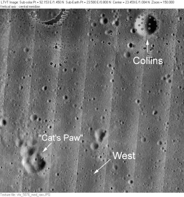
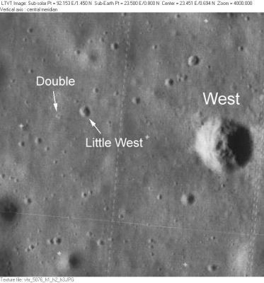
Left: LO-V-076M; Right: LO-V-076H
The view on the left, taken by the medium resolution camera onboard Lunar Orbiter V, shows the location of the IAU-named crater West in relation to Collins and the informally named "Cat's Paw", both of which can, when conditions are just right, be seen though amateur telescopes from Earth. The pair of roughly 1-km diameter craters to the east of the "Cat's Paw" can also be barely seen on the best amateur photos.
The view on the right, taken at the same instant with Lunar Orbiter V's high resolution camera, shows West in more detail. The crater names "Double" and "Little West" are informal names that appear on the Site Traverses Map of the Apollo 11 Landing Site. In its final approach (coming in from the right), the lunar module flew just north of West, passing directly over "Little West" (called "East" on some NASA maps), and finally touching down just short of "Double" crater. Some parts of the rims of the "Cat's Paw" craters can reportedly be seen from this location.
Images
LPOD Photo Gallery Lunar Orbiter Images Apollo Images
Is craterlet West' visible on Apollo 11's LEVA photographs made by Neil Armstrong? (photographs made while Edwin Aldrin descended LM Eagles ladder) (something of a shadowed eastern inner slope of a crater is visible in the distance, looking eastward under the LM's Descent Stage, sans the disturbing glare of the morning sun's light). - DannyCaes Oct 18, 2015

- JohnMoore2
Maps
(LAC zone 60C4) LAC map Geologic map LM map AIC map Site Traverses Map
Description
Description: Wikipedia
Additional Information
- West is about 185 m in diameter and, according to the primary shadow in LO-V-076H, is about 30 m deep. The central peak, casting a tiny secondary shadow, is about 7 m tall. The official IAU diameter is "O km", a common notation for a Landing Site Name.
- In the coordinate system used to calibrate these LTVT versions of the Lunar Orbiter images, the Apollo 11 Lunar Ranging Retroreflector (LRRR), placed just outside the SE rim of the "Double" crater, is at 0.697°N, 23.444°E. The true coordinates of the LRRR in the Mean Earth/Polar coordinates system are 0.67337°N, 23.47293°E. Hence the positions given at the top of the LTVT images need to be shifted by about 0.03 degrees (or about 1 km on the lunar surface). Locating points on the Moon to this precision is surprisingly difficult because of the lack of well-determined reference points. In fact, during its brief stay on the Moon, the Apollo 11 mission controllers were unable to give Command Module pilot Michael Collins sufficiently accurate coordinates for him to find the landing craft visually by reference to previously-established features. The idea that this particular LTVT calibration needs to be corrected by about 0.03 degrees is quite consistent with the offset observed at the independently-determined Apollo Landmark Tracking point near Collins. - JimMosher
- It had been suggested that West crater might have been named for Mareta N. West, a geologist who worked on NASA's Geology Experiment Team during the Apollo 11 mission. It was discovered that West may have been the first to suggest that West crater was the crater that Armstrong had dodged during landing and possibly even on landing day based on the crews description of the approach and of the landing site. Further investigation, however, stongly suggested that the crater had in fact been named prior to the mission for its location in the western part of the Apollo 11 landing ellipse and any connection with Mareta West was a coincidence. This investigation was initiated by Apollo Lunar Surface Journal editor Eric Jones and included a discussion and some research by Ewen Whitaker of the Lunar and Planetary Laboratory after discussions with the current contributor. - jscotti
Nomenclature
- Little West was officially approved by the IAU on the 26 July 2017 - JohnMoore2
- IAU Official pages (Little West and Double) - JohnMoore2
- Astronaut-named feature, Apollo 11 site. This crater served as a landmark near the west end of the planned landing ellipse.
APOD Articles
- APOLLO 11 panorama made at Little West crater (aka East crater), east of LM Eagle
- APOLLO 11 panorama made from CDR Neil Armstrong's LM window (shows the Double crater)
Bibliography

