Difference between revisions of "Poincaré"
| Line 6: | Line 6: | ||
|- | |- | ||
| | | | ||
| − | [http://www.lpod.org/coppermine/displayimage.php?pid=1046&fullsize=1 [[Image: | + | [http://www.lpod.org/coppermine/displayimage.php?pid=1046&fullsize=1 [[Image:Normal_poincare-clem1.jpg|external image normal_poincare-clem1.jpg]]]<br /> |
| | | | ||
| − | [http://www.lpod.org/coppermine/displayimage.php?pid=2371&fullsize=1 [[Image: | + | [http://www.lpod.org/coppermine/displayimage.php?pid=2371&fullsize=1 [[Image:Normal_Poincare-Basin_LIDAR_LTVT_Pike-Spudis_rings.JPG|external image normal_Poincare-Basin_LIDAR_LTVT_Pike-Spudis_rings.JPG]]]<br /> |
|} | |} | ||
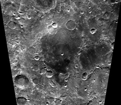
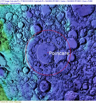
Left: ''[http://lpod.org/coppermine/displayimage.php?pos=-1046 Clementine]'', Right: ''[http://lpod.org/coppermine/displayimage.php?pos=-2371 Clementine]'', Clementine LIDAR Altimeter texture from [http://pdsmaps.wr.usgs.gov/PDS/public/explorer/html/lidrlvls.htm PDS Map-a-Planet] remapped to north-up aerial view by [http://www.henriksucla.dk/ LTVT]. The dot is the center position and the red circle the main ring position from Chuck Wood's [http://www.lpod.org/cwm/DataStuff/Lunar%20Basins.htm Impact Basin Database]. The white circle indicates the location of the 160 km inner ring, which encircles the central mare in the Clementine view.<br /> <br /> <div id="toc"> | Left: ''[http://lpod.org/coppermine/displayimage.php?pos=-1046 Clementine]'', Right: ''[http://lpod.org/coppermine/displayimage.php?pos=-2371 Clementine]'', Clementine LIDAR Altimeter texture from [http://pdsmaps.wr.usgs.gov/PDS/public/explorer/html/lidrlvls.htm PDS Map-a-Planet] remapped to north-up aerial view by [http://www.henriksucla.dk/ LTVT]. The dot is the center position and the red circle the main ring position from Chuck Wood's [http://www.lpod.org/cwm/DataStuff/Lunar%20Basins.htm Impact Basin Database]. The white circle indicates the location of the 160 km inner ring, which encircles the central mare in the Clementine view.<br /> <br /> <div id="toc"> | ||
Latest revision as of 02:09, 16 April 2018
Contents
Poincaré Basin
(unofficial name; IAU crater name: Poincaré; 319 km diam)
| Lat: 56.7°S, Long: 163.6°E, Main ring diam: 325 km, Depth: km, Rükl: (farside) | |
Images
LPOD Photo Gallery Lunar Orbiter Images Apollo Images
Maps
(LAC zone 132D1) USGS Digital Atlas PDF
Basin Classification
(description of terms and most numeric basin data from Wood, C.A. (2004) Impact Basin Database)
| Certainty of Existence |
USGS Age |
Wilhelms Age Group |
Ring Diameters |
Mare Thickness |
Mascon |
| Certain |
Pre-Nectarian |
4 |
160, 325 km |
Description
Description: Wikipedia
Additional Information
- Mare area of 23,750 km^2 according to measurements by Jim Whitford-Stark.
- Crater counts yield mare ages of 3.17 b.y. (S side), 3.47 (NW side), and 3.13 and 3.52 b.y. (E side), evidence of multiple periods of volcanism. Haruyama, J. and others, 2008.
- One of three basins with crustal thickness less than 5 km. The Crust of the Moon as Seen by Grail by Wieczorek et al (2013).
- Atypical exposure of olivine-rich material - from mantle? - surrounding this basin. Yamamoto et al (2010) Nat. Geosci. 3, 533.
- Possible Concentric Crater at (approximately) 158° East, 61° South (LAC 131, near the southwestern part of Poincaré's rim). - DannyCaes Aug 20, 2014
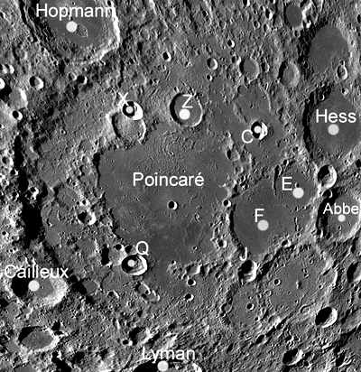
- Two craters within Poincaré's east - Poincaré E and Poincaré F - were adopted into the lunar nomenclature by the IAU on 25 Feb 2016 (see image below).
Nomenclature
- The IAU crater name honors Jules Henri Poincaré (April 29, 1854 – July 17, 1912) one of France's greatest mathematicians and theoretical physicists, and a philosopher of science. Poincaré is often described as a polymath, and in mathematics as 'The Last Universalist', since he excelled in all fields of the discipline as it existed during his lifetime. Poincaré was the 1911 Bruce Medalist of the Astronomical Society of the Pacific, and extensive links to information about him can be found there.
- The name Poincaré (for the crater) was introduced into the IAU nomenclature in the long list of farside names published in Menzel, 1971.
- The impact basin is named after the crater.
- Rima Poincaré Z (an unofficial name from D.Caes for the sinuous rille north of Poincaré Z). http://bit.ly/2EXDe4O
- Officially unnamed (not lettered) large crater with smaller (also unnamed) companion west-southwest of it, both of them located between Abbe M and Poincaré F and poincaré J, see: http://bit.ly/2EgbefV
LPOD Articles
Bibliography


