Difference between revisions of "Nearch"
(Created page with "<div id="content_view" class="wiki" style="display: block"> =Nearch= {| class="wiki_table" | Lat: 58.5°S, Long: 39.1°E, Diam: 75 km, Depth: 4.2 km, [/R%C3%BCkl%2075 Rük...") |
|||
| (2 intermediate revisions by the same user not shown) | |||
| Line 3: | Line 3: | ||
{| class="wiki_table" | {| class="wiki_table" | ||
| | | | ||
| − | Lat: 58.5°S, Long: 39.1°E, Diam: 75 km, Depth: 4.2 km, [ | + | Lat: 58.5°S, Long: 39.1°E, Diam: 75 km, Depth: 4.2 km, [[R%C3%BCkl%2075|Rükl: 75]], pre-Nectarian<br /> |
|} | |} | ||
<div id="toc"> | <div id="toc"> | ||
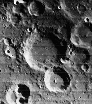
| − | + | [http://www.lpod.org/coppermine/displayimage.php?pid=1828&fullsize=1 [[Image:Normal_Nearch_LO_iv_070_h3.jpg|external image normal_Nearch_LO_iv_070_h3.jpg]]]<br /> ''[http://lpod.org/coppermine/displayimage.php?pos=-1828 LOIV 070 H3]''<br /> <br /> | |
| − | |||
==Images== | ==Images== | ||
[http://www.lpod.org/coppermine/thumbnails.php?album=search&type=full&search=Nearch LPOD Photo Gallery] [http://www.lpi.usra.edu/resources/lunar_orbiter/bin/srch_nam.shtml?Nearch%7C0 Lunar Orbiter Images] [http://www.lpi.usra.edu/resources/apollo/search/feature/?feature=Nearch Apollo Images]<br /> <br /> | [http://www.lpod.org/coppermine/thumbnails.php?album=search&type=full&search=Nearch LPOD Photo Gallery] [http://www.lpi.usra.edu/resources/lunar_orbiter/bin/srch_nam.shtml?Nearch%7C0 Lunar Orbiter Images] [http://www.lpi.usra.edu/resources/apollo/search/feature/?feature=Nearch Apollo Images]<br /> <br /> | ||
==Maps== | ==Maps== | ||
| − | ''([ | + | ''([[LAC%20zone|LAC zone]] 127C2)'' [http://www.lpi.usra.edu/resources/mapcatalog/LAC/lac127/ LAC map] [http://www.lpi.usra.edu/resources/mapcatalog/usgs/I702/ Geologic map]<br /> <br /> |
==Description== | ==Description== | ||
<br /> | <br /> | ||
==Description: Elger== | ==Description: Elger== | ||
| − | ''([ | + | ''([[IAU%20directions|IAU Directions]])'' NEARCH.--A ring-plain, about 35 miles in diameter, on the S.E. of [[Hommel|Hommel]], forming part of the [[Vlacq|Vlacq]] group.<br /> <br /> |
==Description: Wikipedia== | ==Description: Wikipedia== | ||
[http://en.wikipedia.org/wiki/Nearch_(crater) Nearch]<br /> <br /> | [http://en.wikipedia.org/wiki/Nearch_(crater) Nearch]<br /> <br /> | ||
==Additional Information== | ==Additional Information== | ||
| − | Depth data from [ | + | Depth data from [[Kurt%20Fisher%20Crater%20Depths|Kurt Fisher database]]<br /> |
* Westfall, 2000: 4.2 km | * Westfall, 2000: 4.2 km | ||
* Viscardy, 1985: 2.9 km | * Viscardy, 1985: 2.9 km | ||
| Line 31: | Line 30: | ||
<br /> <br /> | <br /> <br /> | ||
---- | ---- | ||
| − | + | </div> | |
Latest revision as of 02:07, 16 April 2018
Contents
Nearch
|
Lat: 58.5°S, Long: 39.1°E, Diam: 75 km, Depth: 4.2 km, Rükl: 75, pre-Nectarian |
Images
LPOD Photo Gallery Lunar Orbiter Images Apollo Images
Maps
(LAC zone 127C2) LAC map Geologic map
Description
Description: Elger
(IAU Directions) NEARCH.--A ring-plain, about 35 miles in diameter, on the S.E. of Hommel, forming part of the Vlacq group.
Description: Wikipedia
Additional Information
Depth data from Kurt Fisher database
- Westfall, 2000: 4.2 km
- Viscardy, 1985: 2.9 km
- Cherrington, 1969: 1.88 km
Nomenclature
Nearchus of Crete (c. 360 - 300 BC) was a Greek explorer and one of the officers in the army of Alexander the Great. His celebrated voyage from India to Susa after Alexander's expedition in India is preserved in Arrian's account, the Indica.
LPOD Articles
Bibliography
