Difference between revisions of "Mouchez"
| Line 5: | Line 5: | ||
|} | |} | ||
<div id="toc"> | <div id="toc"> | ||
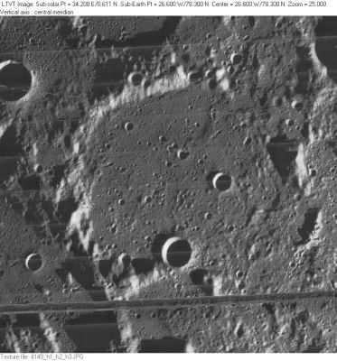
| − | [http://www.lpod.org/coppermine/albums/userpics/Mouchez_LO-IV-140H_LTVT.JPG [[Image: | + | [http://www.lpod.org/coppermine/albums/userpics/Mouchez_LO-IV-140H_LTVT.JPG [[Image:Normal_Mouchez_LO-IV-140H_LTVT.JPG|external image normal_Mouchez_LO-IV-140H_LTVT.JPG]]]<br /> ''[http://lpod.org/coppermine/displayimage.php?pos=-2492 LO-IV-140H]'' 8-km '''Mouchez B''' and 13-km '''Mouchez C''' are on the floor of '''Mouchez''' (which is missing most, if not all, of its eastern and southern rim). 17-km '''Mouchez J''' is partially visible on the left as is 51-km '''Mouchez A''' at the top. The shadows in the upper right come from sculpted hills that are not part of any IAU-named feature.<br /> <br /> |
==Images== | ==Images== | ||
[http://www.lpod.org/coppermine/thumbnails.php?album=search&type=full&search=Mouchez LPOD Photo Gallery] [http://www.lpi.usra.edu/resources/lunar_orbiter/bin/srch_nam.shtml?Mouchez%7C0 Lunar Orbiter Images]<br /> <br /> | [http://www.lpod.org/coppermine/thumbnails.php?album=search&type=full&search=Mouchez LPOD Photo Gallery] [http://www.lpi.usra.edu/resources/lunar_orbiter/bin/srch_nam.shtml?Mouchez%7C0 Lunar Orbiter Images]<br /> <br /> | ||
| Line 15: | Line 15: | ||
[http://en.wikipedia.org/wiki/Mouchez_(crater) Mouchez]<br /> <br /> | [http://en.wikipedia.org/wiki/Mouchez_(crater) Mouchez]<br /> <br /> | ||
==Additional Information== | ==Additional Information== | ||
| − | * Depth data from [[Kurt%20Fisher% | + | * Depth data from [[Kurt%20Fisher%20Crater%20Depths|Kurt Fisher database]] |
** Westfall, 2000: 1.38 km | ** Westfall, 2000: 1.38 km | ||
** Cherrington, 1969: 2.01 km | ** Cherrington, 1969: 2.01 km | ||
| Line 23: | Line 23: | ||
** 0.3 km "A small peak which may be the true central peak" | ** 0.3 km "A small peak which may be the true central peak" | ||
** 0.3 km "A low hill" east of the above two peaks | ** 0.3 km "A low hill" east of the above two peaks | ||
| − | ** 0.3 km "A long dyke extended towards the north wall of Mouchez B" <span class="membersnap">- [http://www.wikispaces.com/user/view/fatastronomer [[Image: | + | ** 0.3 km "A long dyke extended towards the north wall of Mouchez B" <span class="membersnap">- [http://www.wikispaces.com/user/view/fatastronomer [[Image:Fatastronomer-lg.jpg|16px|fatastronomer]]] [http://www.wikispaces.com/user/view/fatastronomer fatastronomer]</span> |
* Mouchez A central peak height | * Mouchez A central peak height | ||
| − | ** [[Sekiguchi%2C%201972|Sekiguchi, 1972]]: 0.5 km <span class="membersnap">- [http://www.wikispaces.com/user/view/fatastronomer [[Image: | + | ** [[Sekiguchi%2C%201972|Sekiguchi, 1972]]: 0.5 km <span class="membersnap">- [http://www.wikispaces.com/user/view/fatastronomer [[Image:Fatastronomer-lg.jpg|16px|fatastronomer]]] [http://www.wikispaces.com/user/view/fatastronomer fatastronomer]</span> |
<br /> | <br /> | ||
==Nomenclature== | ==Nomenclature== | ||
Revision as of 02:06, 16 April 2018
Contents
Mouchez
| Lat: 78.3°N, Long: 26.6°W, Diam: 81 km, Depth: 1.38 km, Rükl: 4 |
LO-IV-140H 8-km Mouchez B and 13-km Mouchez C are on the floor of Mouchez (which is missing most, if not all, of its eastern and southern rim). 17-km Mouchez J is partially visible on the left as is 51-km Mouchez A at the top. The shadows in the upper right come from sculpted hills that are not part of any IAU-named feature.
Images
LPOD Photo Gallery Lunar Orbiter Images
Maps
(LAC zone 3A1) USGS Digital Atlas PDF
Description
Description: Wikipedia
Additional Information
- Depth data from Kurt Fisher database
- Westfall, 2000: 1.38 km
- Cherrington, 1969: 2.01 km
- The peak on the right in LO-IV-140H is about 1700 m tall. - Jim Mosher
- Internal peak heights by Sekiguchi, 1972:
- 0.5 km "A peak on the westerly eccentric position of the floor"
- 0.3 km "A small peak which may be the true central peak"
- 0.3 km "A low hill" east of the above two peaks
- 0.3 km "A long dyke extended towards the north wall of Mouchez B" - fatastronomer fatastronomer
- Mouchez A central peak height
- Sekiguchi, 1972: 0.5 km - fatastronomer fatastronomer
Nomenclature
- Named for Ernest Amedee Barthelemy Mouchez (1821-1892), a French astronomer.
- The name was apparently adopted by the IAU into the original nomenclature scheme of Named Lunar Formations (1935) based on a lunar map published by Gaudibert and Fenet in 1887 (Whitaker, p. 150).
- Is there an unnamed catena passing Mouchez L and Mouchez C?! See http://bit.ly/2lwPuiu (discovered by SandiBandi).
- Interesting discovery SandiBandi !!! (Catena Mouchez C - Mouchez L). Danny C.
LPOD Articles
Bibliography
