Difference between revisions of "Kant"
(Created page with "<div id="content_view" class="wiki" style="display: block"> =Kant= {| class="wiki_table" | Lat: 10.6°S, Long: 20.1°E, Diam: 33 km, Depth: 3.72 km, [http://the-moon.wikis...") |
|||
| (2 intermediate revisions by the same user not shown) | |||
| Line 3: | Line 3: | ||
{| class="wiki_table" | {| class="wiki_table" | ||
| | | | ||
| − | Lat: 10.6°S, Long: 20.1°E, Diam: 33 km, Depth: 3.72 km, [http://the-moon. | + | Lat: 10.6°S, Long: 20.1°E, Diam: 33 km, Depth: 3.72 km, [http://the-moon.us/wiki/R%C3%BCkl%2046 Rükl: 46]<br /> |
|} | |} | ||
| − | [http://www.lpod.org/coppermine/displayimage.php?pid=1735&fullsize=1 [[Image: | + | [http://www.lpod.org/coppermine/displayimage.php?pid=1735&fullsize=1 [[Image:Normal_Kant_AS16-M-0437.jpg|external image normal_Kant_AS16-M-0437.jpg]]][http://www.lpod.org/coppermine/albums/userpics/Kant%20070623%200214.jpg [[Image:Kant%20070623%200214.jpg|external image Kant%20070623%200214.jpg]]]<br /> Left: ''[http://lpod.org/coppermine/displayimage.php?pos=-1735 Apollo 16 image AS16-M-0437 submitted by Stefan Lammel]'' (Thanks, Stefan!), Right: ''[http://lpod.org/coppermine/displayimage.php?pos=-1742 Howard Eskildsen]'', (Thanks, Howard!)<br /> <br /> <div id="toc"> |
| − | + | ||
| − | |||
==Images== | ==Images== | ||
[http://www.lpod.org/coppermine/thumbnails.php?album=search&type=full&search=Kant LPOD Photo Gallery] [http://www.lpi.usra.edu/resources/lunar_orbiter/bin/srch_nam.shtml?Kant%7C0 Lunar Orbiter Images] [http://www.lpi.usra.edu/resources/apollo/search/feature/?feature=Kant Apollo Images]<br /> | [http://www.lpod.org/coppermine/thumbnails.php?album=search&type=full&search=Kant LPOD Photo Gallery] [http://www.lpi.usra.edu/resources/lunar_orbiter/bin/srch_nam.shtml?Kant%7C0 Lunar Orbiter Images] [http://www.lpi.usra.edu/resources/apollo/search/feature/?feature=Kant Apollo Images]<br /> | ||
| Line 16: | Line 15: | ||
<br /> | <br /> | ||
==Maps== | ==Maps== | ||
| − | ''([http://the-moon. | + | ''([http://the-moon.us/wiki/LAC%20zone LAC zone] 78C1)'' [http://www.lpi.usra.edu/resources/mapcatalog/LAC/lac78/ LAC map] [http://www.lpi.usra.edu/resources/mapcatalog/usgs/I546/ Geologic map] [http://www.lpi.usra.edu/resources/mapcatalog/LM/lm78/ LM map] [http://www.lpi.usra.edu/resources/mapcatalog/LTO/lto78c1_1/ LTO map]<br /> <br /> |
==Description== | ==Description== | ||
<br /> | <br /> | ||
==Description: Elger== | ==Description: Elger== | ||
| − | ''([http://the-moon. | + | ''([http://the-moon.us/wiki/IAU%20directions IAU Directions])'' KANT.--A conspicuous ring-plain, 23 miles in diameter, situated in a mountainous district W. of [http://the-moon.us/wiki/Theophilus Theophilus], with lofty terraced walls and a bright central peak. Adjoining it on the E. is a mountain mass, projecting from the coast-line of the Mare, on which there is a peak rising to more than 14,000 feet above the surface.<br /> <br /> |
==Description: Wikipedia== | ==Description: Wikipedia== | ||
[http://en.wikipedia.org/wiki/Kant_(crater) Kant]<br /> <br /> | [http://en.wikipedia.org/wiki/Kant_(crater) Kant]<br /> <br /> | ||
==Additional Information== | ==Additional Information== | ||
| − | * Depth data from [http://the-moon. | + | * Depth data from [http://the-moon.us/wiki/Kurt%20Fisher%20Crater%20Depths Kurt Fisher database]<br /> Pike, 1976: 3.72 km<br /> Arthur, 1974: 3.12 km<br /> Westfall, 2000: 3.72 km<br /> Viscardy, 1985: 2.7 km<br /> Cherrington, 1969: 0.88 km |
| − | * Satellite craters '''Kant P''' and '''Z''' are on the [http://the-moon. | + | * Satellite craters '''Kant P''' and '''Z''' are on the [http://the-moon.us/wiki/ALPO%20list%20of%20bright%20ray%20craters ALPO list of bright ray craters]. |
| − | * A thermal anomaly crater, implying a youthful age - [http://the-moon. | + | * A thermal anomaly crater, implying a youthful age - [http://the-moon.us/wiki/Moore%20et%20al%2C%201980 Moore et al, 1980] |
| − | * '''Kant''' is one of the craters in which a transient event has been reliably reported, by the French astronomer Trouvelot in January 1873; on the 4th of that month he stated that the crater was 'filled with mist'. Source: Patrick Moore's ''New Guide to the Moon'' (1976), page 289.<span class="membersnap">- | + | * '''Kant''' is one of the craters in which a transient event has been reliably reported, by the French astronomer Trouvelot in January 1873; on the 4th of that month he stated that the crater was 'filled with mist'. Source: Patrick Moore's ''New Guide to the Moon'' (1976), page 289.<span class="membersnap">- DannyCaes <small>May 19, 2012</small></span> |
<br /> | <br /> | ||
==Nomenclature== | ==Nomenclature== | ||
| Line 35: | Line 34: | ||
This informal name needs investigation. There are several books and sources on the web which mention the '''Kant Plateau''', such as:<br /> - [https://books.google.be/books?id=5r5UAAAAYAAJ&pg=PA226&lpg=PA226&dq=kant+plateau&source=bl&ots=6ZRrPn-6oq&sig=CAniClYUWVGUacJhYyw-S30dfUk&hl=nl&sa=X&ved=0CD4Q6AEwB2oVChMIsbT0iMurxwIVBC4aCh1OGwFZ#v=onepage&q=kant%20plateau&f=false Geological Survey Professional Paper-1981]<br /> - [https://books.google.be/books?id=gFzwAAAAMAAJ&pg=RA4-PA29&lpg=RA4-PA29&dq=kant+plateau&source=bl&ots=4cISVO4O8B&sig=KB5x7R7tUy0cPntJytJhOqDMass&hl=nl&sa=X&ved=0CEIQ6AEwCGoVChMIsbT0iMurxwIVBC4aCh1OGwFZ#v=onepage&q=kant%20plateau&f=false United States Geological Survey Professional Paper-1969]<br /> - [https://repository.si.edu/handle/10088/6323 Regional Chemical Setting of the Apollo 16 Landing Site and the Importance of the Kant Plateau]<br /> See also:<br /> - ''TO A ROCKY MOON; A Geologist's History of Lunar Exploration'' (Don E. Wilhelms).<br /> - The lower right corner of Chart 12 (page 37) in the ''21st Century Atlas of the Moon'' (Charles A. Wood/ Maurice J.S. Collins).<br /> <br /> | This informal name needs investigation. There are several books and sources on the web which mention the '''Kant Plateau''', such as:<br /> - [https://books.google.be/books?id=5r5UAAAAYAAJ&pg=PA226&lpg=PA226&dq=kant+plateau&source=bl&ots=6ZRrPn-6oq&sig=CAniClYUWVGUacJhYyw-S30dfUk&hl=nl&sa=X&ved=0CD4Q6AEwB2oVChMIsbT0iMurxwIVBC4aCh1OGwFZ#v=onepage&q=kant%20plateau&f=false Geological Survey Professional Paper-1981]<br /> - [https://books.google.be/books?id=gFzwAAAAMAAJ&pg=RA4-PA29&lpg=RA4-PA29&dq=kant+plateau&source=bl&ots=4cISVO4O8B&sig=KB5x7R7tUy0cPntJytJhOqDMass&hl=nl&sa=X&ved=0CEIQ6AEwCGoVChMIsbT0iMurxwIVBC4aCh1OGwFZ#v=onepage&q=kant%20plateau&f=false United States Geological Survey Professional Paper-1969]<br /> - [https://repository.si.edu/handle/10088/6323 Regional Chemical Setting of the Apollo 16 Landing Site and the Importance of the Kant Plateau]<br /> See also:<br /> - ''TO A ROCKY MOON; A Geologist's History of Lunar Exploration'' (Don E. Wilhelms).<br /> - The lower right corner of Chart 12 (page 37) in the ''21st Century Atlas of the Moon'' (Charles A. Wood/ Maurice J.S. Collins).<br /> <br /> | ||
==LPOD Articles== | ==LPOD Articles== | ||
| − | [http:// | + | [http://www2.lpod.org/wiki/December_10,_2006 Ring Around a Basin.]<br /> <br /> |
==Bibliography== | ==Bibliography== | ||
'''Kant P''': ''APOLLO OVER THE MOON; A VIEW FROM ORBIT'', Chapter 5: Craters ([http://www.hq.nasa.gov/office/pao/History/SP-362/ch5.2.htm Part 2]), Figure 118.<br /> <br /> | '''Kant P''': ''APOLLO OVER THE MOON; A VIEW FROM ORBIT'', Chapter 5: Craters ([http://www.hq.nasa.gov/office/pao/History/SP-362/ch5.2.htm Part 2]), Figure 118.<br /> <br /> | ||
---- | ---- | ||
| − | + | </div> | |
Latest revision as of 01:55, 16 April 2018
Contents
Kant
|
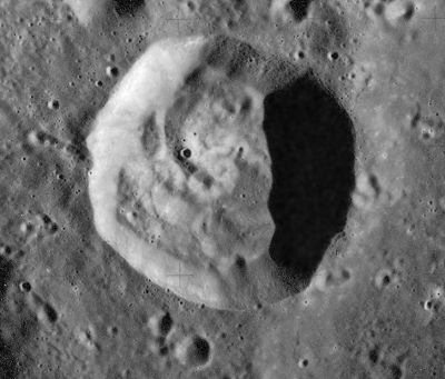
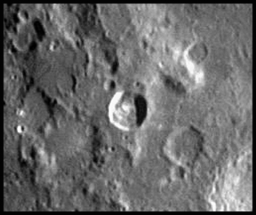
Lat: 10.6°S, Long: 20.1°E, Diam: 33 km, Depth: 3.72 km, Rükl: 46 |


Left: Apollo 16 image AS16-M-0437 submitted by Stefan Lammel (Thanks, Stefan!), Right: Howard Eskildsen, (Thanks, Howard!)
Images
LPOD Photo Gallery Lunar Orbiter Images Apollo Images
- Two "forgotten" orbital Hasselblads of Kant and environs, made during the mission of Apollo 12:
- AS12-50-7427, AS12-50-7428 In both of these east-looking oblique photographs Kant is the pronounced crater just above the centres of the frames.
- A small bowl-shaped raycrater on the floor of Kant was frequently photographed during the mission of Apollo 16. Because it (this small raycrater) has a high albedo value, there's reflected light on its inner shadowed slopes. This reflected light is visible on the Arizona State University's zoomify scan of Apollo 16's mapping/metric Fairchild camera frame AS16-M-0698 (shows Kant near the frame's right margin). Please zoom in on the small raycrater!
- Research orbital Apollo 12 and Apollo 16 photography: Danny Caes
Maps
(LAC zone 78C1) LAC map Geologic map LM map LTO map
Description
Description: Elger
(IAU Directions) KANT.--A conspicuous ring-plain, 23 miles in diameter, situated in a mountainous district W. of Theophilus, with lofty terraced walls and a bright central peak. Adjoining it on the E. is a mountain mass, projecting from the coast-line of the Mare, on which there is a peak rising to more than 14,000 feet above the surface.
Description: Wikipedia
Additional Information
- Depth data from Kurt Fisher database
Pike, 1976: 3.72 km
Arthur, 1974: 3.12 km
Westfall, 2000: 3.72 km
Viscardy, 1985: 2.7 km
Cherrington, 1969: 0.88 km - Satellite craters Kant P and Z are on the ALPO list of bright ray craters.
- A thermal anomaly crater, implying a youthful age - Moore et al, 1980
- Kant is one of the craters in which a transient event has been reliably reported, by the French astronomer Trouvelot in January 1873; on the 4th of that month he stated that the crater was 'filled with mist'. Source: Patrick Moore's New Guide to the Moon (1976), page 289.- DannyCaes May 19, 2012
Nomenclature
Immanuel Kant (22 April 1724 – 12 February 1804) was a German philosopher. He is regarded as one of the most influential thinkers of modern Europe and the last major philosopher of the Enlightenment.
Kant Plateau
This informal name needs investigation. There are several books and sources on the web which mention the Kant Plateau, such as:
  - Geological Survey Professional Paper-1981
  - United States Geological Survey Professional Paper-1969
  - Regional Chemical Setting of the Apollo 16 Landing Site and the Importance of the Kant Plateau
  See also:
  - TO A ROCKY MOON; A Geologist's History of Lunar Exploration (Don E. Wilhelms).
  - The lower right corner of Chart 12 (page 37) in the 21st Century Atlas of the Moon (Charles A. Wood/ Maurice J.S. Collins).
LPOD Articles
Bibliography
Kant P: APOLLO OVER THE MOON; A VIEW FROM ORBIT, Chapter 5: Craters (Part 2), Figure 118.