Difference between revisions of "Focas"
(Created page with "<div id="content_view" class="wiki" style="display: block"> =Focas= {| class="wiki_table" | Lat: 33.7°S, Long: 93.8°W, Diam: 22 km, Depth: 3.42 km, Rükl: ''(farside)'',...") |
|||
| (2 intermediate revisions by the same user not shown) | |||
| Line 3: | Line 3: | ||
{| class="wiki_table" | {| class="wiki_table" | ||
| | | | ||
| − | Lat: 33.7°S, Long: 93.8°W, Diam: 22 km, Depth: 3.42 km, Rükl: ''(farside)'', [ | + | Lat: 33.7°S, Long: 93.8°W, Diam: 22 km, Depth: 3.42 km, Rükl: ''(farside)'', [[Stratigraphy|Copernican]]<br /> |
|} | |} | ||
<div id="toc"> | <div id="toc"> | ||
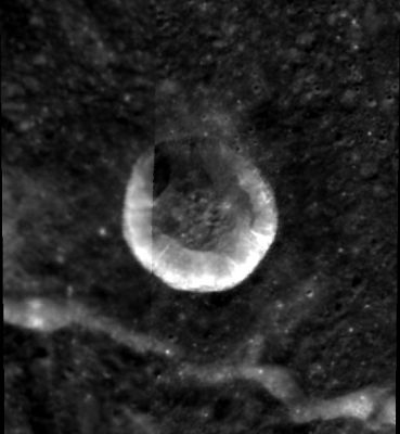
| − | + | [http://www.lpod.org/coppermine/displayimage.php?pid=2239&fullsize=1 [[Image:Normal_focas-clem1.jpg|external image normal_focas-clem1.jpg]]]<br /> ''[http://lpod.org/coppermine/displayimage.php?pos=-2239 Clementine]''<br /> <br /> | |
| − | |||
==Images== | ==Images== | ||
[http://www.lpod.org/coppermine/thumbnails.php?album=search&type=full&search=Focas LPOD Photo Gallery] [http://www.lpi.usra.edu/resources/lunar_orbiter/bin/srch_nam.shtml?Focas%7C0 Lunar Orbiter Images]<br /> <br /> | [http://www.lpod.org/coppermine/thumbnails.php?album=search&type=full&search=Focas LPOD Photo Gallery] [http://www.lpi.usra.edu/resources/lunar_orbiter/bin/srch_nam.shtml?Focas%7C0 Lunar Orbiter Images]<br /> <br /> | ||
==Maps== | ==Maps== | ||
| − | ''([ | + | ''([[LAC%20zone|LAC zone]] 123B1)'' [http://planetarynames.wr.usgs.gov/images/Lunar/lac_123.pdf USGS Digital Atlas PDF]<br /> <br /> |
==Description== | ==Description== | ||
<br /> | <br /> | ||
| Line 17: | Line 16: | ||
[http://en.wikipedia.org/wiki/Focas_(lunar_crater) Focas]<br /> <br /> | [http://en.wikipedia.org/wiki/Focas_(lunar_crater) Focas]<br /> <br /> | ||
==Additional Information== | ==Additional Information== | ||
| − | Depth data from [ | + | Depth data from [[Kurt%20Fisher%20Crater%20Depths|Kurt Fisher database]]<br /> |
* Westfall, 2000: 3.42 km | * Westfall, 2000: 3.42 km | ||
<br /> | <br /> | ||
| Line 29: | Line 28: | ||
<br /> <br /> | <br /> <br /> | ||
---- | ---- | ||
| − | + | </div> | |
Latest revision as of 01:49, 16 April 2018
Contents
Focas
|
Lat: 33.7°S, Long: 93.8°W, Diam: 22 km, Depth: 3.42 km, Rükl: (farside), Copernican |
Images
LPOD Photo Gallery Lunar Orbiter Images
Maps
(LAC zone 123B1) USGS Digital Atlas PDF
Description
Description: Wikipedia
Additional Information
Depth data from Kurt Fisher database
- Westfall, 2000: 3.42 km
Nomenclature
- Named for Ionnas (Jean-Henri) Focas (1909-1969), a Greek/French astronomer.
LPOD Articles
Bibliography
