Difference between revisions of "Delporte"
| (One intermediate revision by the same user not shown) | |||
| Line 5: | Line 5: | ||
Lat: 16.0°S, Long: 121.6°E, Diam: 45 km, Depth: 3.37 km, Rükl: ''(farside)'', [[Stratigraphy|Upper Imbrian]]<br /> | Lat: 16.0°S, Long: 121.6°E, Diam: 45 km, Depth: 3.37 km, Rükl: ''(farside)'', [[Stratigraphy|Upper Imbrian]]<br /> | ||
|} | |} | ||
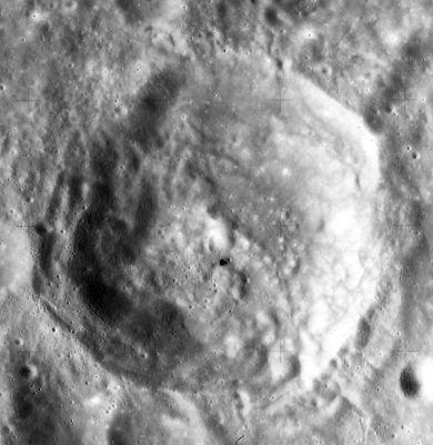
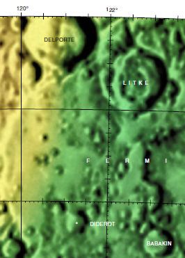
| − | [http://lpod.org/coppermine/displayimage.php?pid=4416&fullsize=1 [[Image: | + | [http://lpod.org/coppermine/displayimage.php?pid=4416&fullsize=1 [[Image:Normal_delporte-large.jpg|external image normal_delporte-large.jpg]]][[Image:Del-lit-color.jpg|del-lit-color.jpg]]<br /> '''Left:''' [http://www.lpi.usra.edu/resources/apollo/frame/?AS15-M-0895 Apollo AS15-M-0985] image (orientated for North top) from the [http://www.lpi.usra.edu Lunar & Planetary Institute]. '''Right:''' [http://planetarynames.wr.usgs.gov/images/Lunar/lac_101.pdf Color-coded topography LAC 101] image from [[USGS%20Digital%20Atlas|USGS Digital Atlas]].<div id="toc"> |
| − | + | <br /> <br /> <br /> | |
| − | |||
==Images== | ==Images== | ||
[http://www.lpod.org/coppermine/thumbnails.php?album=search&type=full&search=Delporte LPOD Photo Gallery] [http://www.lpi.usra.edu/resources/lunar_orbiter/bin/srch_nam.shtml?Delporte%7C0 Lunar Orbiter Images] [http://www.lpi.usra.edu/resources/apollo/search/feature/?feature=Delporte Apollo Images]<br /> <br /> | [http://www.lpod.org/coppermine/thumbnails.php?album=search&type=full&search=Delporte LPOD Photo Gallery] [http://www.lpi.usra.edu/resources/lunar_orbiter/bin/srch_nam.shtml?Delporte%7C0 Lunar Orbiter Images] [http://www.lpi.usra.edu/resources/apollo/search/feature/?feature=Delporte Apollo Images]<br /> <br /> | ||
| Line 17: | Line 16: | ||
[http://en.wikipedia.org/wiki/Delporte_(crater) Delporte]<br /> <br /> | [http://en.wikipedia.org/wiki/Delporte_(crater) Delporte]<br /> <br /> | ||
==Additional Information== | ==Additional Information== | ||
| − | * Depth data from [[Kurt%20Fisher% | + | * Depth data from [[Kurt%20Fisher%20Crater%20Depths|Kurt Fisher database]] |
** Pike, 1976: 3.37 km | ** Pike, 1976: 3.37 km | ||
* [[Central%20peak%20composition|Central peak composition]]: A ([[Tompkins%20%26%20Pieters%2C%201999|Tompkins & Pieters, 1999]]) | * [[Central%20peak%20composition|Central peak composition]]: A ([[Tompkins%20%26%20Pieters%2C%201999|Tompkins & Pieters, 1999]]) | ||
| Line 28: | Line 27: | ||
<br /> <br /> | <br /> <br /> | ||
---- | ---- | ||
| − | + | </div> | |
Latest revision as of 01:46, 16 April 2018
Contents
Delporte
|
Lat: 16.0°S, Long: 121.6°E, Diam: 45 km, Depth: 3.37 km, Rükl: (farside), Upper Imbrian |


Left: Apollo AS15-M-0985 image (orientated for North top) from the Lunar & Planetary Institute. Right: Color-coded topography LAC 101 image from USGS Digital Atlas.
Images
LPOD Photo Gallery Lunar Orbiter Images Apollo Images
Maps
Description
Description: Wikipedia
Additional Information
- Depth data from Kurt Fisher database
- Pike, 1976: 3.37 km
- Central peak composition: A (Tompkins & Pieters, 1999)
Nomenclature
Eugène Joseph Delporte (January 10, 1882–October 19, 1955) was a Belgian astronomer. He discovered a total of 66 asteroids. He discovered or co-discovered some comets as well. In 1930 he fixed the modern boundaries between all of the constellations in the sky, along lines of right ascension and declination for the epoch B1875.0.
LPOD Articles
Bibliography