Difference between revisions of "Horrebow"
| Line 6: | Line 6: | ||
|} | |} | ||
<div id="toc"> | <div id="toc"> | ||
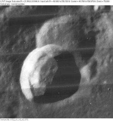
| − | + | [http://www.lpod.org/coppermine/albums/userpics/Horrebow_LO-IV-152H_LTVT.JPG [[Image:normal_Horrebow_LO-IV-152H_LTVT.JPG|external image normal_Horrebow_LO-IV-152H_LTVT.JPG]]]<br /> ''[http://lpod.org/coppermine/displayimage.php?pos=-2494 LO-IV-152H]'' '''Horrebow''' is to the lower left of center, overlapping 25-km '''Horrebow A''' in the upper right.<br /> <br /> | |
| − | |||
==Images== | ==Images== | ||
[http://www.lpod.org/coppermine/thumbnails.php?album=search&type=full&search=Horrebow LPOD Photo Gallery] [http://www.lpi.usra.edu/resources/lunar_orbiter/bin/srch_nam.shtml?Horrebow%7C0 Lunar Orbiter Images]<br /> <br /> | [http://www.lpod.org/coppermine/thumbnails.php?album=search&type=full&search=Horrebow LPOD Photo Gallery] [http://www.lpi.usra.edu/resources/lunar_orbiter/bin/srch_nam.shtml?Horrebow%7C0 Lunar Orbiter Images]<br /> <br /> | ||
| Line 23: | Line 22: | ||
* Viscardy, 1985: 2.5 km | * Viscardy, 1985: 2.5 km | ||
| − | * The shadows in LO-IV-152H indicate that the depth is about 2600 m. However it is less in the south and more in the north, especially around the location of the bright peak. '''Horrebow A''' is about 2000 m deep. <span class="membersnap">- | + | * The shadows in LO-IV-152H indicate that the depth is about 2600 m. However it is less in the south and more in the north, especially around the location of the bright peak. '''Horrebow A''' is about 2000 m deep. <span class="membersnap">- Jim Mosher</span> |
<br /> | <br /> | ||
==Nomenclature== | ==Nomenclature== | ||
| Line 36: | Line 35: | ||
* Page 138: '''The Satellite of Venus''' (T.W.Webb, ''Nature'', 1876). | * Page 138: '''The Satellite of Venus''' (T.W.Webb, ''Nature'', 1876). | ||
* Page 142: '''The Supposed Satellite of Venus''' (''Observatory'', 1887). | * Page 142: '''The Supposed Satellite of Venus''' (''Observatory'', 1887). | ||
| − | <u>Note</u>: these strange articles are from the days when a natural satellite in orbit around Venus was still seen as a possibility... (or perhaps not?). Anyway, the observing eyes of lots of professional and amateur astronomers were glued to the eyepieces of their telescopes. Perhaps a bit too much glued, because most of them didn't observe the supposed "natural" satellite (called "''Neith''"), but... rather the unexpected ghost image of the bright Venus itself, reflected between the lenses of the telescope's eyepiece! (a visual side effect created by poor optics, or...??). <span class="membersnap">- | + | <u>Note</u>: these strange articles are from the days when a natural satellite in orbit around Venus was still seen as a possibility... (or perhaps not?). Anyway, the observing eyes of lots of professional and amateur astronomers were glued to the eyepieces of their telescopes. Perhaps a bit too much glued, because most of them didn't observe the supposed "natural" satellite (called "''Neith''"), but... rather the unexpected ghost image of the bright Venus itself, reflected between the lenses of the telescope's eyepiece! (a visual side effect created by poor optics, or...??). <span class="membersnap">- DannyCaes <small>Apr 19, 2015</small></span><br /> We could ask questions about telescopic observers of binary and multiple star systems. Were they really observing binary and multiple stars, or were most of them just adjacent ghost images of singular bright stars? <span class="membersnap">- DannyCaes <small>Apr 19, 2015</small></span><br /> |
---- | ---- | ||
| − | + | </div> | |
Revision as of 16:26, 15 April 2018
Contents
Horrebow
|
Lat: 58.7°N, Long: 40.8°W, Diam: 24 km, Depth: 3.01 km, Rükl: 2, Erathostenian |
LO-IV-152H Horrebow is to the lower left of center, overlapping 25-km Horrebow A in the upper right.
Images
LPOD Photo Gallery Lunar Orbiter Images
Maps
(LAC zone 11A3) LAC map Geologic map
Description
Description: Elger
(IAU Directions) HORREBOW.--A ring-plain of remarkable shape, resembling the analemma figure, standing at the S. end of the mountain range bounding J.F.W. Herschel on the E. Schmidt shows a crater on the E. wall, near the constriction on this side, and a second at the foot of the slope of the W. wall.
Description: Wikipedia
Additional Information
Depth data from Kurt Fisher database
- Westfall, 2000: 3.01 km
- Viscardy, 1985: 2.5 km
- The shadows in LO-IV-152H indicate that the depth is about 2600 m. However it is less in the south and more in the north, especially around the location of the bright peak. Horrebow A is about 2000 m deep. - Jim Mosher
Nomenclature
Peder; Danish astronomer (1679-1764).
LPOD Articles
Bibliography
A certain Horrebow in the Sourcebook Project (William R. Corliss)
(articles in which the name Horrebow is mentioned) (probably Peder Horrebow)
  - In Mysterious Universe, a handbook of astronomical anomalies (1979) :
- Page 138: The Satellite of Venus (T.W.Webb, Nature, 1876).
- Page 142: The Supposed Satellite of Venus (Observatory, 1887).
Note: these strange articles are from the days when a natural satellite in orbit around Venus was still seen as a possibility... (or perhaps not?). Anyway, the observing eyes of lots of professional and amateur astronomers were glued to the eyepieces of their telescopes. Perhaps a bit too much glued, because most of them didn't observe the supposed "natural" satellite (called "Neith"), but... rather the unexpected ghost image of the bright Venus itself, reflected between the lenses of the telescope's eyepiece! (a visual side effect created by poor optics, or...??). - DannyCaes Apr 19, 2015
We could ask questions about telescopic observers of binary and multiple star systems. Were they really observing binary and multiple stars, or were most of them just adjacent ghost images of singular bright stars? - DannyCaes Apr 19, 2015
