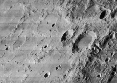
Strabo
Contents
Strabo (and Thales west of it)
|
Lat: 61.9°N, Long: 54.3°E, Diam: 55 km, Depth: 3.3 km, Rükl: 6,, Nectarian |

LOIV-165-H1
Strabo is the larger one of the depicted couple of craters. The small one is Thales.
Images
LPOD Photo Gallery Lunar Orbiter Images
Maps
(LAC zone 14A2) USGS Digital Atlas PDF
Description
Description: Elger
(IAU Directions) STRABO.--A small walled-plain, 32 miles in diameter, connected with the N. border of De La Rue.
Description: Wikipedia
Additional Information
Depth data from Kurt Fisher database
- Westfall, 2000: 4.42 km
- Cherrington, 1969: 3.81 km
- Measures on LRO QuickMap give max depth about 3.9, ave about 3.3 km
- Measures on LRO QuickMap give height of central peak bump about 125 m
- Included in ALPO list of bright ray craters
- Included on the ALPO list of banded craters
Nomenclature
- Strabo (63/64 BC – ca. AD 24) was a Greek historian, geographer and philosopher. He is mostly famous for his 17-volume work Geographica, which presented a descriptive history of people and places from different regions of the world known to his era.
- Crater Strabo A was called Abineri by Hugh Percy Wilkins and Patrick Moore (see their book THE MOON), but the I.A.U. did not accept that name. Abineri is a contemporary English selenographer.
- de Ulloa (plate T. LXXIII) (name first used by Van Langren). This formation is limbward of Schröter's "Thales", which in turn appears to be the modern Strabo. Schröter's "de Ulloa" is most likely Antonio de Ulloa (1716–1795) who participated in the French expedition to Ecuador to measure the length of an arc of the terrestrial meridian. Van Langren's "de Ulloa" might possibly be Francisco de Ulloa an earlier Spanish explorer. Research Jim Mosher and Danny Caes
LPOD Articles
Bibliography
Strabo A ("Abineri"): THE MOON by H.P.Wilkins and P.Moore.