Silberschlag
Contents
Silberschlag
|
Lat: 6.19°N, Long: 12.51°E, Diam: 13.04 km, Depth: 2.54 km, [/R%C3%BCkl%2034 Rükl: 34] |
Table of Contents

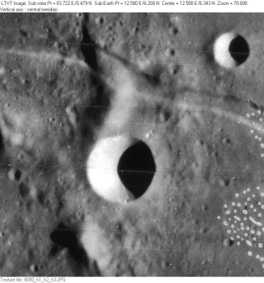
LO-IV-090H The rille passing through the upper part of the picture is [/Rima%20Ariadaeus Rima Ariadaeus]. To its north, 7-km Silberschlag A is visible in the upper right. The ridge to the north of Silberschlag is regarded as part of the east rim of 25-km Silberschlag P. The ridge to the south is not regarded as part of any named crater.
Images
LPOD Photo Gallery Lunar Orbiter Images Apollo Images
- One of Apollo 10's oblique western views of [/Rima%20Ariadaeus Rima Ariadaeus] (Hasselblad AS10-31-4646), see the LPI's low-res scan, shows Silberschlag below and to the left of the frame's centre.
- GRIN's hi-res scan of AS10-31-4646 shows the smooth-looking inner slopes and sharp rim of Silberschlag.
- Research Danny Caes
Maps
([/LAC%20zone LAC zone] 60D1) LAC map Geologic map LM map AIC map
Description
Elger
([/IAU%20Directions IAU Directions]) SILBERSCHLAG.--A very brilliant crater, 8 or 9 miles in diameter, connected with the great mountain range just referred to. The [/Ariadaeus Ariadaeus] cleft cuts through the range a few miles N. of it. This neighbourhood at sunrise presents a grand spectacle. With high powers under good atmospheric conditions, the plain W. of the mountains is seen to be traversed by a number of shallow winding valleys, trending towards [/Agrippa Agrippa], and separated by low rounded hills which have all the appearance of having been moulded by the action of water.
Wikipedia
Additional Information
- IAU page: Silberschlag
- Depth data from [/Kurt%20Fisher%20crater%20depths Kurt Fisher database]
- Arthur, 1974: 2.54 km
- Westfall, 2000: 2.54 km
- Viscardy, 1985: 2.53 km
- The shadows in LO-IV-090H indicate Silberschlag is up to 2570 m deep (there is a rise of about 200 m at the midpoint of the east rim). - JimMosher JimMosher
- Included on the [/ALPO%20list%20of%20banded%20craters ALPO list of banded craters]
Nomenclature
- Named for Johann Esaias Silberschlag (1721 – 1791). Born in Aschersleben, Germany, he was a theologian and natural scientist.
- According to [/Whitaker Whitaker] (p. 218), this name was introduced by [/Schr%C3%B6ter Schröter].
LPOD Articles
Bibliography
- Hill, Harold. 1991. [/Hill%2C%201991 A Portfolio of Lunar Drawings]., page 4 (the [/Rima%20Ariadaeus Ariadaeus rille] at sunset).
[/Alphabetical%20Index Named Features] -- Prev: [/Sikorsky Sikorsky] -- Next: [/Simpelius Simpelius]
This page has been edited 1 times. The last modification was made by - tychocrater tychocrater on Jun 13, 2009 3:24 pm - afx4u3