Difference between revisions of "Rimae Menelaus"
| Line 18: | Line 18: | ||
[http://www.lpod.org/coppermine/thumbnails.php?album=search&type=full&search=Rimae%20Menelaus LPOD Photo Gallery] [http://www.lpi.usra.edu/resources/lunar_orbiter/bin/srch_nam.shtml?Rimae%20Menelaus%7C0 Lunar Orbiter Images] [http://www.lpi.usra.edu/resources/apollo/search/feature/?feature=Rimae%20Menelaus Apollo Images]<br /> <br /> | [http://www.lpod.org/coppermine/thumbnails.php?album=search&type=full&search=Rimae%20Menelaus LPOD Photo Gallery] [http://www.lpi.usra.edu/resources/lunar_orbiter/bin/srch_nam.shtml?Rimae%20Menelaus%7C0 Lunar Orbiter Images] [http://www.lpi.usra.edu/resources/apollo/search/feature/?feature=Rimae%20Menelaus Apollo Images]<br /> <br /> | ||
==Maps== | ==Maps== | ||
| − | ''([ | + | ''([[LAC%20zone|LAC zone]] 42D3)'' [http://www.lpi.usra.edu/resources/mapcatalog/LAC/lac42/ LAC map] [http://www.lpi.usra.edu/resources/mapcatalog/usgs/I489/ Geologic map] [http://www.lpi.usra.edu/resources/mapcatalog/LM/lm42/ LM map] [http://www.lpi.usra.edu/resources/mapcatalog/LTO/lto42d3_1/ LTO map]<br /> <br /> |
==Description== | ==Description== | ||
<br /> | <br /> | ||
| Line 26: | Line 26: | ||
<br /> | <br /> | ||
==Nomenclature== | ==Nomenclature== | ||
| − | Named from nearby crater. ([ | + | Named from nearby crater. ([[Menelaus|Menelaus]])<br /> Unofficially known as '''Fossae Menelaus''', see Lunar Topographic Orthophotomap 42-D3.<br /> The most western part of '''Rimae Menelaus/ Fossae Menelaus''' has a dome called '''Menelaus Zeta''', located north-northwest of '''Menelaus''' itself (see Chart 30 in the ''Times Atlas of the Moon''). <span class="membersnap">- [http://www.wikispaces.com/user/view/DannyCaes [[Image:DannyCaes-lg.jpg|16px|DannyCaes]]] [http://www.wikispaces.com/user/view/DannyCaes DannyCaes] <small>Oct 21, 2015</small></span><br /> <br /> |
==LPOD Articles== | ==LPOD Articles== | ||
[http://www2.lpod.org/wiki/May_25,_2005 An IR strip across a Kipuka]<br /> [http://www2.lpod.org/wiki/May_14,_2005 Ancient Island]<br /> <br /> | [http://www2.lpod.org/wiki/May_25,_2005 An IR strip across a Kipuka]<br /> [http://www2.lpod.org/wiki/May_14,_2005 Ancient Island]<br /> <br /> | ||
Revision as of 16:11, 15 April 2018
Contents
Rimae Menelaus
(unofficially known as Fossae Menelaus)
| Lat: 17.2°N, Long: 17.9°E, Length: 131 km, Depth: km, Rükl: 24 |
Table of Contents
[#Rimae Menelaus Rimae Menelaus]
[#Rimae Menelaus-Images Images]
[#Rimae Menelaus-Maps Maps]
[#Rimae Menelaus-Description Description]
[#Rimae Menelaus-Description: Wikipedia Description: Wikipedia]
[#Rimae Menelaus-Additional Information Additional Information]
[#Rimae Menelaus-Nomenclature Nomenclature]
[#Rimae Menelaus-LPOD Articles LPOD Articles]
[#Rimae Menelaus-Bibliography Bibliography]
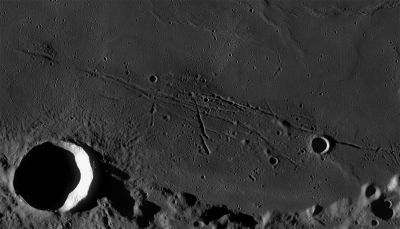
Left: LROC WAC mosaic (No.'s M117379381ME, M117372616ME). Processed by LROC_WAC_Previewer.
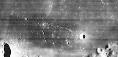
Right: LOIV 090 H2
Images
LPOD Photo Gallery Lunar Orbiter Images Apollo Images
Maps
(LAC zone 42D3) LAC map Geologic map LM map LTO map
Description
Description: Wikipedia
Additional Information
Nomenclature
Named from nearby crater. (Menelaus)
  Unofficially known as Fossae Menelaus, see Lunar Topographic Orthophotomap 42-D3.
  The most western part of Rimae Menelaus/ Fossae Menelaus has a dome called Menelaus Zeta, located north-northwest of Menelaus itself (see Chart 30 in the Times Atlas of the Moon). - DannyCaes DannyCaes Oct 21, 2015
LPOD Articles
An IR strip across a Kipuka
Ancient Island
Bibliography
This page has been edited 1 times. The last modification was made by - tychocrater tychocrater on Jun 13, 2009 3:24 pm - afx3u2

