Rima Bradley
Contents
Rima Bradley
(unofficially called Fossa Bradley)
|
Lat: 24.15°N, Long: 0.6°W, Length: 133.76 km, Depth: km, [/R%C3%BCkl%2022 Rükl: 22] |
Table of Contents
[#Rima Bradley Rima Bradley]
[#Rima Bradley-Images Images]
[#Rima Bradley-Maps Maps]
[#Rima Bradley-Description Description]
[#Rima Bradley-Description: Wikipedia Description: Wikipedia]
[#Rima Bradley-Additional Information Additional Information]
[#Rima Bradley-Nomenclature Nomenclature]
[#Rima Bradley-LROC Article LROC Article]
[#Rima Bradley-LPOD Articles LPOD Articles]
[#Rima Bradley-Bibliography Bibliography]

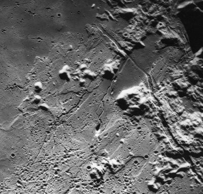
Apollo 15 image AS15-M-0417
In this frame, North is to the left, the Apennine range at upper right, the odd depression Kathleen slightly below centre of frame, and Rima Bradley runs from the lower right corner toward the centre of the frame's upper margin. Note also the flat low-albedo region at upper right of the frame's centre, which was unofficially called Lacus Mozart during the hey-days of Project Apollo, although this (disallowed) name was not printed on the Lunar Topographic Orthophotomaps (LTO). - DannyCaes DannyCaes Oct 19, 2015
Images
LPOD Photo Gallery Lunar Orbiter Images Apollo Images
Maps
([/LAC%20zone LAC zone] 41D2) LAC map Geologic map LM map LTO map
Description
Description: Wikipedia
Additional Information
- IAU page: Rima Bradley
Nomenclature
Named from nearby Mons. ([/Mons%20Bradley Mons Bradley]).
  Once called Fossa Bradley on Lunar Topographic Orthophotomaps 41-A3, 41-B4, 41-D2.
LROC Article
LPOD Articles
Bibliography
[/Alphabetical%20Index Named Features] -- Prev: Mons Bradley -- Next: Bragg
This page has been edited 1 times. The last modification was made by - tychocrater tychocrater on Jun 13, 2009 3:24 pm - afx3u2