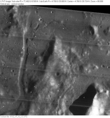
Promontorium Fresnel
Contents
Promontorium Fresnel
(formerly Cape Fresnel)
|
Lat: 29.0°N, Long: 4.7°E, Diam: 20 km, Depth: km, Rükl: 22 |
LO-IV-102H Promontorium Fresnel is the tip of the peninsula jutting up the center of the frame. The shadows suggest a height of about 770 m near the tip, increasing to the south. To its west is a small part of a roughly 2 km wide channel of Rimae Fresnel. The shadows suggests depths of up to 200 m. On the right-hand side of this image one can see the triangular shadow from an unnamed peak north of Santos-Dumont. The shadows indicate it has a height of about 3,000 m.
Images
LPOD Photo Gallery images Lunar Orbiter Images Apollo Images
Maps
(LAC zone 41B1) LAC map Geologic map LM map
Description
Description: Wikipedia
Additional Information
Nomenclature
- Augustin Jean; French optician (1788-1827).
  - The pass between Promontorium Fresnel and Schmidt's Promontorium Faraday north of it (which is the southern part of the Montes Caucasus) is unofficially called the Straits of Fresnel by Charles Wood. It is also called The Great Pass (the pass between Mare Imbrium and Mare Serenitatis).
  - A hill northeast of Promontorium Fresnel seems to have received the Greek letter designation "Psi " (Fresnel Psi?).
  - Another hill east of Promontorium Fresnel was called "Phi" (Fresnel Phi ?) (source of both Phi and Psi: System of Lunar Craters, 1966).
LPOD Articles
Bibliography
