Pilâtre
Contents
Pilâtre
(formerly Hausen B)
|
Lat: 60.2°S, Long: 86.9°W, Diam: 50 km, Depth: km, Rükl 70 |
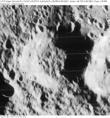
LO-IV-193H Pilâtre is sandwiched between 59-km Chappe (on its west) and 70-km Pingré S (on its east). The 32-km crater immediately to the southeast of Pilâtre is an unnamed feature on the west rim of Pingré S.
Images
LPOD Photo Gallery Lunar Orbiter Images
- Pilatre was also captured near the lower margin of Lunar Orbiter IV's frame LO-IV-187-med.
- Research Danny Caes
Maps
(LAC zone 135C3) USGS Digital Atlas PDF
Description
Description: Wikipedia
Additional Information
- From the shadows in LO-IV-193H, the east rim of Pilâtre is 4700-5200 m above the floor. - Jim Mosher
Nomenclature
Jean-François Pilâtre de Rozier; French aeronaut (1756-1785).
- According to Whitaker (p. 236), this replacement name for a formerly lettered crater was introduced in NASA RP-1097. It was approved by the IAU in 1991 (IAU Transactions XXIA).
- Before this crater was officially known as Pilatre, there might have been a slight possibility that it would have received the name Gant by John Westfall and the ALPO. Gant was the original new name of Hugh Percy Wilkins for Archimedes A (nowadays officially known as Bancroft). Note: for the list of Wilkins's new names, see Appendix R in Ewen A. Whitaker's book Mapping and Naming the Moon. See also: Luna Incognita (the Gant/ Pilatre case). - DannyCaes Oct 9, 2014
- Erroneously printed as Piltre (without "a") on page 76 (libration chart 5) in the 21st Century Atlas of the Moon (2012).- DannyCaes Jan 23, 2013
LPOD Articles
Bibliography
