Difference between revisions of "Marius Hills"
(Created page with "<div id="content_view" class="wiki" style="display: block"> =Marius Hills= ''(unofficial name)''<br /> {| class="wiki_table" | Lat: 12.4°N, Long: 54.0°W, Diam: 27.8 km...") |
|||
| (3 intermediate revisions by the same user not shown) | |||
| Line 4: | Line 4: | ||
{| class="wiki_table" | {| class="wiki_table" | ||
| | | | ||
| − | Lat: 12.4°N, Long: 54.0°W, Diam: 27.8 km, Depth: km, [ | + | Lat: 12.4°N, Long: 54.0°W, Diam: 27.8 km, Depth: km, [[R%C3%BCkl%2029|Rükl 29]]<br /> |
|} | |} | ||
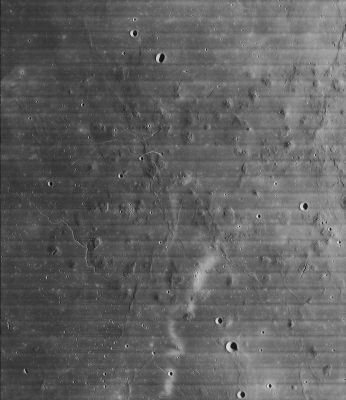
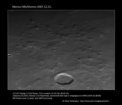
| − | [http://www.lpod.org/coppermine/albums/userpics/Marius_Hills_IV-157-H2.jpg [[Image: | + | [http://www.lpod.org/coppermine/albums/userpics/Marius_Hills_IV-157-H2.jpg [[Image:Normal_Marius_Hills_IV-157-H2.jpg|external image normal_Marius_Hills_IV-157-H2.jpg]]][http://www.lpod.org/coppermine/albums/userpics/marius-hills_2007.12.21.jpg [[Image:Normal_marius-hills_2007.12.21.jpg|external image normal_marius-hills_2007.12.21.jpg]]]<br /> '''Left''': ''[http://lpod.org/coppermine/displayimage.php?pos=-703 LO-IV-157-H2]'' North is up in this overhead view in which the namesake crater [[Marius|Marius]] is out of the field to the right. The sinuous rille on the left (a little below center) is [[Rima%20Galilaei|Rima Galilaei]].<br /> '''Right''': ''[http://lpod.org/coppermine/displayimage.php?pos=-3170 Oliver Pettenpaul]'' In this image, north is to the right. The namesake crater, [[Marius|Marius]] is at the bottom; and the photo extends from 8-km '''[[Reiner|Reiner]] H''' and 5-km '''[[Marius|Marius]] X''' on the left to the identically sized '''[[Marius|Marius]] L''' and '''Q''' on the right (these two pairs of craters are also visible at the bottom and top of the [[Lunar%20Orbiter|Lunar Orbiter]] overhead view).<br /> <div id="toc"> |
| − | + | ||
| − | |||
==Images== | ==Images== | ||
[http://www.lpod.org/coppermine/thumbnails.php?album=search&type=full&search=Marius LPOD Photo Gallery] [http://www.lpi.usra.edu/resources/lunar_orbiter/bin/srch_nam.shtml?Marius%7C0 Lunar Orbiter Images] [http://www.lpi.usra.edu/resources/apollo/search/feature/?feature= Apollo Images][http://jda.jaxa.jp/jda/p4_e.php?f_id=15972&mode=level&time=N&genre=5&category=5025 Kaguya HDTV]<br /> <br /> | [http://www.lpod.org/coppermine/thumbnails.php?album=search&type=full&search=Marius LPOD Photo Gallery] [http://www.lpi.usra.edu/resources/lunar_orbiter/bin/srch_nam.shtml?Marius%7C0 Lunar Orbiter Images] [http://www.lpi.usra.edu/resources/apollo/search/feature/?feature= Apollo Images][http://jda.jaxa.jp/jda/p4_e.php?f_id=15972&mode=level&time=N&genre=5&category=5025 Kaguya HDTV]<br /> <br /> | ||
| − | * An impressive orbital photograph of the '''Marius Hills''' (made by Lunar Orbiter 2; [http://www.lpi.usra.edu/resources/lunarorbiter/frame/?2213 Frame 2213]) was included on pages 220-221 in the ''National Geographic'' of February 1969 (''The Moon'' by Kenneth F. Weaver). Research:<span class="membersnap">- | + | * An impressive orbital photograph of the '''Marius Hills''' (made by Lunar Orbiter 2; [http://www.lpi.usra.edu/resources/lunarorbiter/frame/?2213 Frame 2213]) was included on pages 220-221 in the ''National Geographic'' of February 1969 (''The Moon'' by Kenneth F. Weaver). Research:<span class="membersnap">- DannyCaes <small>Mar 24, 2008</small></span> |
| − | * Impressive close-ups of the domefield and rilles west-northwest of '''Marius''' were made by Lunar Orbiter 5: Frames [http://www.lpi.usra.edu/resources/lunarorbiter/frame/?5211 211], [http://www.lpi.usra.edu/resources/lunarorbiter/frame/?5212 212], [http://www.lpi.usra.edu/resources/lunarorbiter/frame/?5213 213], [http://www.lpi.usra.edu/resources/lunarorbiter/frame/?5214 214], [http://www.lpi.usra.edu/resources/lunarorbiter/frame/?5215 215], and [http://www.lpi.usra.edu/resources/lunarorbiter/frame/?5216 216]. <span class="membersnap">- | + | * Impressive close-ups of the domefield and rilles west-northwest of '''Marius''' were made by Lunar Orbiter 5: Frames [http://www.lpi.usra.edu/resources/lunarorbiter/frame/?5211 211], [http://www.lpi.usra.edu/resources/lunarorbiter/frame/?5212 212], [http://www.lpi.usra.edu/resources/lunarorbiter/frame/?5213 213], [http://www.lpi.usra.edu/resources/lunarorbiter/frame/?5214 214], [http://www.lpi.usra.edu/resources/lunarorbiter/frame/?5215 215], and [http://www.lpi.usra.edu/resources/lunarorbiter/frame/?5216 216]. <span class="membersnap">- DannyCaes <small>Mar 24, 2008</small></span> |
<br /> | <br /> | ||
==Maps== | ==Maps== | ||
| − | ''([ | + | ''([[LAC%20zone|LAC zone]] 56B)'' [http://www.lpi.usra.edu/resources/mapcatalog/LAC/lac56/ LAC map] [http://www.lpi.usra.edu/resources/mapcatalog/usgs/I491/ Geologic map] [http://www.lpod.org/coppermine/displayimage.php?pid=964&fullsize=1 Lunar Topophotomap] [http://lunar.gsfc.nasa.gov/lola/science.html LRO LOLA Topo Map] (See 3.18.2010)<br /> <br /> |
==Description== | ==Description== | ||
| − | Informal name for a region in [ | + | Informal name for a region in [[Oceanus%20Procellarum|Oceanus Procellarum]] peppered with volcanic domes and rilles.<br /> <br /> |
==Description: Neison== | ==Description: Neison== | ||
| − | ''([ | + | ''([[IAU%20directions|IAU Directions]])'' (from [[Neison%2C%201876|Neison, 1876]], p. [http://books.google.com/books?id=jkUI4moKjnQC&vq=marius&dq=inauthor%3A%22Edmund%20Neison%22&as_brr=1&pg=PA316&ci=169%2C346%2C711%2C286&source=bookclip 316]): '''[[Marius|Marius]].''' ... On the west extend a very great number of these ridges together with many hills and the highest points here are '''Marius ''Epsilon''''' which rises 1,042 feet above the plain and '''''Iota''''' which is perhaps 900 feet high. ... East of [[Marius|Marius]] are a considerable number of craterlets together with a number of hills only visible near the terminator though the craterlets are distinct even in Full.<br /> <br /> |
==Description: Wikipedia== | ==Description: Wikipedia== | ||
[http://en.wikipedia.org/wiki/Marius_(crater Marius]<br /> <br /> | [http://en.wikipedia.org/wiki/Marius_(crater Marius]<br /> <br /> | ||
==Additional Information== | ==Additional Information== | ||
| − | * The '''Marius Hills''' are an area of thermal cooling anomalies [ | + | * The '''Marius Hills''' are an area of thermal cooling anomalies [[Moore%20et%20al%2C%201980|Moore et al, 1980]], for craters this implies youthful ages, but since these are known old volcanoes it probably means that fresh rocks are exposed on steep slopes. |
| − | * Other concentrations of domes can be found near the craters [ | + | * Other concentrations of domes can be found near the craters [[Hortensius|Hortensius]] and [[Milichius|Milichius]]. |
| − | * See also [ | + | * See also [[RoI%20-%20Marius%20Hills|Marius Hills]] Constellation Region of Interest. |
<br /> | <br /> | ||
==Nomenclature== | ==Nomenclature== | ||
| − | * Unofficially named after the nearby crater ([ | + | * Unofficially named after the nearby crater ([[Marius|Marius]]). |
| − | * In the original IAU nomenclature of [ | + | * In the original IAU nomenclature of [[Blagg%20and%20M%C3%BCller|Blagg and Müller]] about seven of the individual peaks had Greek-lettered designations. More were added in the ''[[System%20of%20Lunar%20Craters|System of Lunar Craters]]'', but all of these were dropped by the IAU in [[IAU%20Transactions%20XVB|1973]]. |
<br /> | <br /> | ||
==APOD Articles== | ==APOD Articles== | ||
| Line 43: | Line 42: | ||
==LPOD Articles== | ==LPOD Articles== | ||
| − | * [http:// | + | * [http://www2.lpod.org/wiki/November_23,_2007 Little Hills, Huge Hole] |
| − | * [http:// | + | * [http://www2.lpod.org/wiki/August_28,_2004 Volcanic Hills in the Ocean of Storms] |
| − | * [http:// | + | * [http://www2.lpod.org/wiki/May_22,_2006 Domes, Domes Everywhere] |
| − | * [ | + | * [[LPOD%20Mar%2022%2C%202008|Another Megadome]] |
* [http://lpod.wikispaces.com/July%2010%2C%202008 Rilles and Hills] | * [http://lpod.wikispaces.com/July%2010%2C%202008 Rilles and Hills] | ||
* [http://lpod.wikispaces.com/November%2024%2C%202008 Marius and its hills] | * [http://lpod.wikispaces.com/November%2024%2C%202008 Marius and its hills] | ||
| Line 64: | Line 63: | ||
<br /> | <br /> | ||
---- | ---- | ||
| − | + | </div> | |
Latest revision as of 03:04, 16 April 2018
Contents
Marius Hills
(unofficial name)
|
Lat: 12.4°N, Long: 54.0°W, Diam: 27.8 km, Depth: km, Rükl 29 |


Left: LO-IV-157-H2 North is up in this overhead view in which the namesake crater Marius is out of the field to the right. The sinuous rille on the left (a little below center) is Rima Galilaei.
Right: Oliver Pettenpaul In this image, north is to the right. The namesake crater, Marius is at the bottom; and the photo extends from 8-km Reiner H and 5-km Marius X on the left to the identically sized Marius L and Q on the right (these two pairs of craters are also visible at the bottom and top of the Lunar Orbiter overhead view).
Images
LPOD Photo Gallery Lunar Orbiter Images Apollo ImagesKaguya HDTV
- An impressive orbital photograph of the Marius Hills (made by Lunar Orbiter 2; Frame 2213) was included on pages 220-221 in the National Geographic of February 1969 (The Moon by Kenneth F. Weaver). Research:- DannyCaes Mar 24, 2008
- Impressive close-ups of the domefield and rilles west-northwest of Marius were made by Lunar Orbiter 5: Frames 211, 212, 213, 214, 215, and 216. - DannyCaes Mar 24, 2008
Maps
(LAC zone 56B) LAC map Geologic map Lunar Topophotomap LRO LOLA Topo Map (See 3.18.2010)
Description
Informal name for a region in Oceanus Procellarum peppered with volcanic domes and rilles.
Description: Neison
(IAU Directions) (from Neison, 1876, p. 316): Marius. ... On the west extend a very great number of these ridges together with many hills and the highest points here are Marius Epsilon which rises 1,042 feet above the plain and Iota which is perhaps 900 feet high. ... East of Marius are a considerable number of craterlets together with a number of hills only visible near the terminator though the craterlets are distinct even in Full.
Description: Wikipedia
Additional Information
- The Marius Hills are an area of thermal cooling anomalies Moore et al, 1980, for craters this implies youthful ages, but since these are known old volcanoes it probably means that fresh rocks are exposed on steep slopes.
- Other concentrations of domes can be found near the craters Hortensius and Milichius.
- See also Marius Hills Constellation Region of Interest.
Nomenclature
- Unofficially named after the nearby crater (Marius).
- In the original IAU nomenclature of Blagg and Müller about seven of the individual peaks had Greek-lettered designations. More were added in the System of Lunar Craters, but all of these were dropped by the IAU in 1973.
APOD Articles
LROC Articles
LPOD Articles
- Little Hills, Huge Hole
- Volcanic Hills in the Ocean of Storms
- Domes, Domes Everywhere
- Another Megadome
- Rilles and Hills
- Marius and its hills
- No Dome
- The Hills were once alive, but there was no music
Bibliography
- Arya, A. S. et al (2011). Morphometric and Rheological Analysis of an Effusive Dome in Marius Hills Using Chandrayaan-1 TMC Data – 42nd LPSC Conference (Mar), 2011.
- Lawrence, S. J. et al (2011). Size Frequency Distribution of Blocks on Lunar Volcanic Landforms: Results from LROC – 42nd LPSC Conference (Mar), 2011.
- Lynn, M. C. et al (2011). A Radar Survey of Lunar Dome Fields. – 42nd LPSC Conference (Mar), 2011.
- Tran, T. et al (2011). Morphology of Lunar Volcanic Domes from LROC – 42nd LPSC Conference (Mar), 2011.
- David J. Heather, Sarah K. Dunkin & Lionel Wilson. 2003. Volcanism on the Marius Hills Plateau: Observational analyses using Clementine multispectral data Journal of Geophysical Research, Vol. 108, No. E3, 5017. (full abstract).
- Ronald Greeley. 1971. Lava tubes and channels in the lunar Marius Hills. The Moon, 3, 3 pp. 289-314. (free version)
- B. A. Campbell, B. R. Hawke, and D. B. Campbell. 2008. Rugged Flow Morphology of Lunar Domes Revealed by Earth-Based Radar. LPSC 39 #1299.
- Google Scholar references