Le Monnier
Contents
Le Monnier (Luna 21 / Lunokhod 2 site)
|
Lat: 26.6°N, Long: 30.6°E, Diam: 60 km, Depth: 2.4 km, Rükl 25 |

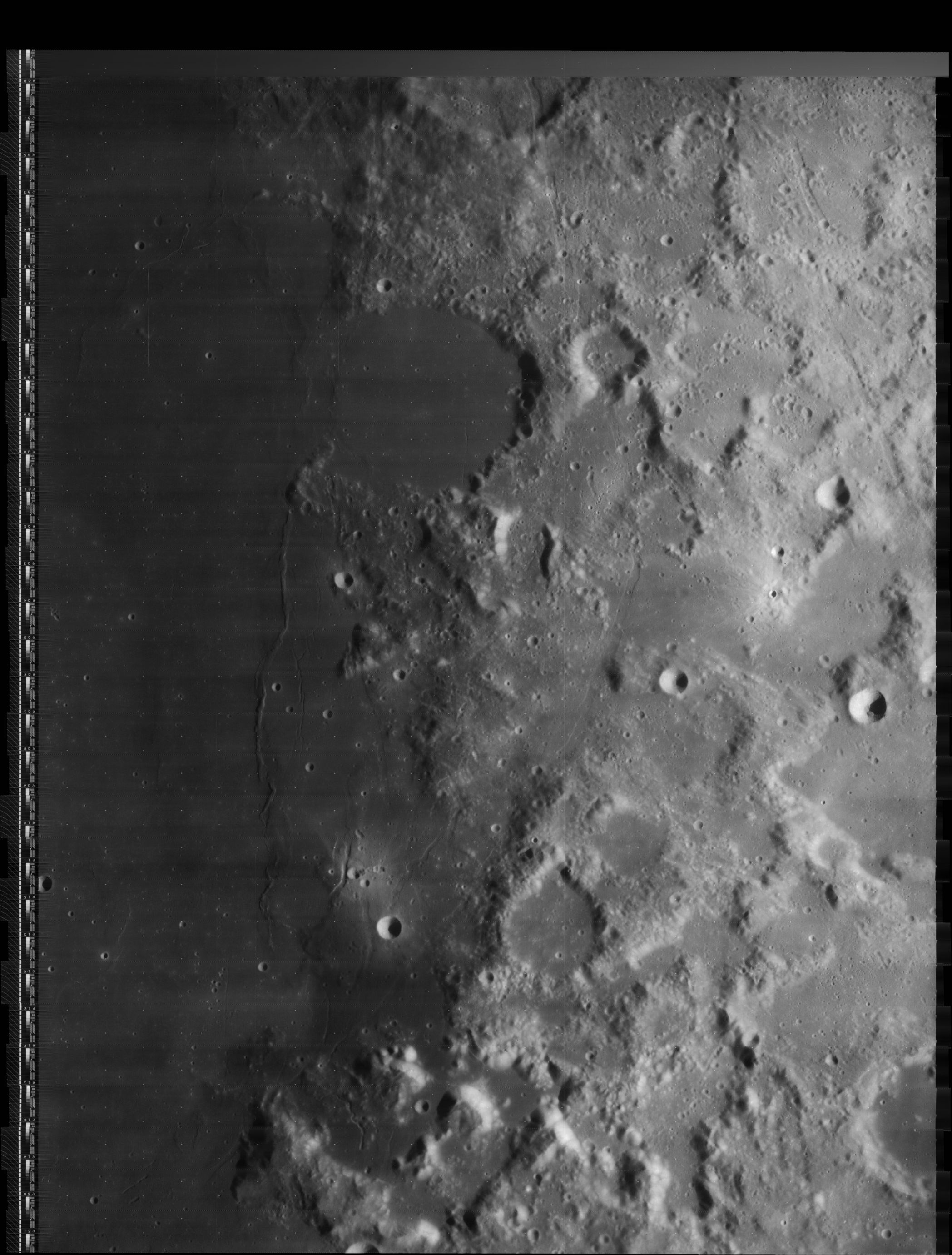
LOIV 078 H3
The High-Resolution scan of LOIV 078 H3 reveals the curious rille at the southeastern part of Le Monnier's floor, which was called Fossa Recta during the days of Lunokhod 2's exploration of Le Monnier's southern part.
Images
LPOD Photo Gallery Lunar Orbiter Images Apollo Images
- The first frame in Apollo 15's color-Hasselblad magazine 87-KK (frame AS15-87-11695) shows crater Le Monnier L (south of Le Monnier itself and slightly northwest of Littrow Alpha). Crater Le Monnier L is seen near the frame's lower left corner, while the Command Module of Apollo 15 (the Endeavour) was captured near the frame's centre. On this online scan, north is toward the bottom of the frame.
- The second frame in magazine 87-KK (frame AS15-87-11696) shows the unnamed peninsula slightly northwest of Le Monnier L and east of the surface formation which was once called Fossae Pavlova (an unofficial name on the corresponding LTO map).
- Research Apollo 15 photography: Danny Caes
Maps
(LAC zone 43A4) LAC map Geologic map LTO map
Description
Description: Elger
(IAU Directions) LE MONNIER.--A great inflection or bay on the E. border of the Mare Serenitatis S. of Posidonius. Like many other similar formations on the edges of the Maria, it appears at one time or other to have had a continuous rampart, which on the side facing the "sea" has been destroyed. In this, as in most of the other cases, relics of the ruin are traceable under oblique light. A fine crescent-shaped mountain, 3,000 feet high, stands near the S. side of the gap, and probably represents a portion of a once lofty wall. It will repay the observer to watch the progress of sunrise on the whole of the E. coast-line of the Mare up to Mount Argaeus.
Description: Wikipedia
Additional Information
- Depth data from Kurt Fisher database
- Viscardy, 1985: 2.4 km
- Cherrington, 1969: 2.22 km
- The "cape" at Le Monnier's southwestern rim (which is connected to the northern part of Dorsa Aldrovandi) is described and depicted in NASA SP-362 APOLLO OVER THE MOON; A VIEW FROM ORBIT, Chapter 4: The Maria (Part 2), Figure 78.
- There's a curious chain of elongated depressions on the floor of Le Monnier, which is described and depicted in Chapter 7: Unusual Features (Part 1), Figure 224. (see also LPOD Close-up of a Rille).
- Near Le Monnier KA (a small craterlet in Mare Serenitatis, northwest of Le Monnier itself) is a curious feature which looks like a snake. There's a photograph of it in Chapter 6: Rimae (Part 1: Sinuous Rimae), Figure 190. The system which is composed of Le Monnier KA, the "snake", and some craterlets in the neighbourhood, looks very much like a "smiley"! Detection of the snake's (or the smiley's) exact location (near Le Monnier KA): - DannyCaes Dec 24, 2007
Luna 21 and Lunokhod 2
- Lunokhod 2, the second unmanned rover on the moon (delivered by the lander Luna 21) crawled its way on the southern part of Le Monnier's floor. Surface photographs, made by the cameras aboard Lunokhod 2, are online in Don P. Mitchell's excellent site Soviet Moon Images. - DannyCaes Dec 24, 2007
Nomenclature
- Named for Pierre Charles Le Monnier (November 23, 1715 – May 31, 1799), a French astronomer. His name is sometimes given as Lemonnier. Le Monnier was born in Paris, where his father Pierre (1675-1757), also an astronomer, was professor of philosophy at the college d'Harcourt. His first recorded astronomical observation was made before he was sixteen, and the presentation of an elaborate lunar map resulted in his admission to the Academy, on April 21, 1736, aged only twenty.
- According to Whitaker (p. 119), Le Monnier was one of eight names introduced by Lohrmann. All of Lohrmann's names were adopted by the three "authorities" cited in Mary Blagg's Collated List, and incorporated into the original IAU nomenclature of Blagg and Müller (1935).
- This feature was catalog entry 508 in the original IAU nomenclature of Blagg and Müller, where it is spelled Le Monnier. In possible contradiction to Whitaker's claim, the name is attributed there to Schröter.
- Kuiper, in his 1961 "corrections" to the IAU nomenclature in his Photographic Lunar Atlas insisted this name should be spelled "Lemonnier"; but the IAU, although approving most of his changes, rejected this one and several of his other corrections to the spelling of French names (IAU Transactions XIB). One can only guess this had something to do with the chairman of the Lunar Commission, at the time, being a Frenchman (A. Dolfus) and perhaps understanding French better than Kuiper and his British-born assistants. - Jim Mosher
- Not content to let dead horses lie, NASA SP-241 (not an official IAU document) assures us the correct way to spell and capitalize this name is "la Monnier" (p. 538), but the "a" seems to be a misprint since everywhere else an "e" is used (e.g., "le Monnier" on p. 535). The IAU does not accept the claim that the "l" should be in lower case print. - Jim Mosher
LPOD Articles
Close-Up of a Rille (the curious chain of elongated depressions on Le Monnier's floor, which was explored by Lunokhod 2).
The end of Secrets (the discovery of Lunokhod 2 on high-resolution LRO images).
LROC Articles
Soviet Union Lunar Rovers (Luna 17/Lunokhod 1 and Luna 21/Lunokhod 2).
Luna 21 Lander
Bibliography