Kiva
Contents
Kiva (Apollo 16 site craterlet name)
|
Lat: 8.6°S, Long: 15.5°E, Diam: 1 km, Depth: km, Rükl: 45 |

Images
LPOD Photo Gallery Lunar Orbiter Images Apollo Images
Maps
(LAC zone 78D2) LAC map Geologic map LM map LTO map Topophotomap 78D2/S1
Description
The Landing Site Name "Kiva" is plotted on Site Traverses chart 78D2S2.
Description: Wikipedia
(no Wikipedia page for Apollo 16's crater Kiva).
Additional Information
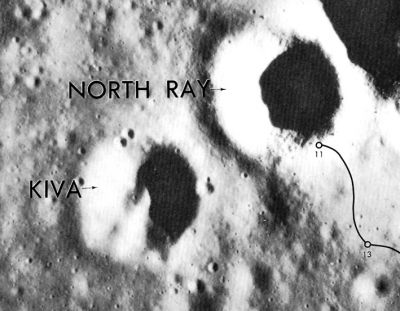
It is perhaps possible to observe Kiva through very powerful telescopes, or to make digital webcam photographs of it (also through powerful telescopes). Kiva has the same diameter as its northeastern neighbour North Ray Crater, and should be observed during the hours when there's enough shadow on its inner slopes (as seen in the orbital photograph above). The albedo of Kiva is rather low, and because of this it is not observable during Full Moon. North Ray Crater on the other hand is a very easy observer's target just before, during, and after Full Moon!- DannyCaes Apr 25, 2010
Nomenclature
Astronaut-named feature, Apollo 16 site.
 Kiva: southwest of North Ray crater, named after the Pueblo Indian architectural structure which is usually round.
LPOD Articles
Bibliography
David M. Harland: EXPLORING THE MOON, the Apollo expeditions.
  Eric M. Jones: APOLLO LUNAR SURFACE JOURNAL (ALSJ).