Difference between revisions of "Harriot"
(Created page with "<div id="content_view" class="wiki" style="display: block"> =Harriot= {| class="wiki_table" | colspan="2" | Lat: 33.2°N, Long: 114.25°E, Diam: 53.74 km, Depth: km, Rükl:...") |
|||
| (3 intermediate revisions by the same user not shown) | |||
| Line 5: | Line 5: | ||
|- | |- | ||
| | | | ||
| − | [http://www.lpod.org/coppermine/displayimage.php?pid=5149&fullsize=1 [[Image: | + | [http://www.lpod.org/coppermine/displayimage.php?pid=5149&fullsize=1 [[Image:Normal_harriot.jpg|external image normal_harriot.jpg]]][http://www.lpod.org/coppermine/displayimage.php?pid=2075&fullsize=1 [[Image:Normal_harriot-clem1.jpg|external image normal_harriot-clem1.jpg]]]<br /> |
|} | |} | ||
'''Left:''' ''[http://lroc.sese.asu.edu/index.html LROC]'' WAC image No. [http://wms.lroc.asu.edu/lroc/view_lroc/LRO-L-LROC-2-EDR-V1.0/M130904717ME M130904717ME] (see also the '''Lettered craters''' image below).<br /> '''Right:''' ''[http://lpod.org/coppermine/displayimage.php?pos=-2075 Clementine]''<br /> <div id="toc"> | '''Left:''' ''[http://lroc.sese.asu.edu/index.html LROC]'' WAC image No. [http://wms.lroc.asu.edu/lroc/view_lroc/LRO-L-LROC-2-EDR-V1.0/M130904717ME M130904717ME] (see also the '''Lettered craters''' image below).<br /> '''Right:''' ''[http://lpod.org/coppermine/displayimage.php?pos=-2075 Clementine]''<br /> <div id="toc"> | ||
| − | + | ||
| − | |||
==Images== | ==Images== | ||
| − | [http://www.lpod.org/coppermine/thumbnails.php?album=search&type=full&search=Harriot LPOD Photo Gallery] [http://www.lpi.usra.edu/resources/lunar_orbiter/bin/srch_nam.shtml?Harriot%7C0 Lunar Orbiter Images] [http://www.lpi.usra.edu/resources/apollo/search/feature/?feature=Harriot Apollo Images]<br /> The peculiar "amphi-theatre" shaped '''Harriot''' was captured near the lower part of the right margin of Apollo 16's ''Fairchild''-camera frame [http://www.lpi.usra.edu/resources/apollo/frame/?AS16-M-3001 AS16-M-3001], which was made during TEC (Trans Earth Coast).<br /> Research: Danny Caes<br /> It should be mentioned: investigating this (rather unknown) part of the lunar farside with help of P.Spudis's and B.Bussey's ''Clementine Atlas of the Moon'' (LAC 30, page 61) is quite an adventure! <span class="membersnap">- | + | [http://www.lpod.org/coppermine/thumbnails.php?album=search&type=full&search=Harriot LPOD Photo Gallery] [http://www.lpi.usra.edu/resources/lunar_orbiter/bin/srch_nam.shtml?Harriot%7C0 Lunar Orbiter Images] [http://www.lpi.usra.edu/resources/apollo/search/feature/?feature=Harriot Apollo Images]<br /> The peculiar "amphi-theatre" shaped '''Harriot''' was captured near the lower part of the right margin of Apollo 16's ''Fairchild''-camera frame [http://www.lpi.usra.edu/resources/apollo/frame/?AS16-M-3001 AS16-M-3001], which was made during TEC (Trans Earth Coast).<br /> Research: Danny Caes<br /> It should be mentioned: investigating this (rather unknown) part of the lunar farside with help of P.Spudis's and B.Bussey's ''Clementine Atlas of the Moon'' (LAC 30, page 61) is quite an adventure! <span class="membersnap">- DannyCaes <small>Nov 5, 2012</small></span><br /> <br /> |
==Maps== | ==Maps== | ||
| − | ''([http://the-moon. | + | ''([http://the-moon.us/wiki/LAC%20zone LAC zone] 30D3)'' [http://planetarynames.wr.usgs.gov/images/Lunar/lac_30.pdf USGS Digital Atlas PDF]<br /> <br /> |
==Description== | ==Description== | ||
<br /> | <br /> | ||
| Line 21: | Line 20: | ||
* IAU page: [http://planetarynames.wr.usgs.gov/Feature/2374 Harriot] | * IAU page: [http://planetarynames.wr.usgs.gov/Feature/2374 Harriot] | ||
* There is a large amount of literature related to '''Harriot''' - some of the principal references are listed to Allan Chapman in the Bibliography section below. | * There is a large amount of literature related to '''Harriot''' - some of the principal references are listed to Allan Chapman in the Bibliography section below. | ||
| − | * Harriot's lunar observations had been [http://books.google.com/books?id=u-Q3AAAAMAAJ&pg=PA153#v=onepage&q&f=false mentioned] as early as 1784/1785 by [http://the-moon. | + | * Harriot's lunar observations had been [http://books.google.com/books?id=u-Q3AAAAMAAJ&pg=PA153#v=onepage&q&f=false mentioned] as early as 1784/1785 by [http://the-moon.us/wiki/Zach Baron Zach]. A more extensive account of Harriot's papers, including an explanation of Zach's involvement, appeared in Rigaud's ''Supplement'': |
<br /> | <br /> | ||
==Nomenclature== | ==Nomenclature== | ||
| Line 27: | Line 26: | ||
* Named for [http://en.wikipedia.org/wiki/Thomas_Harriot Thomas Harriot] (1560-1621), a British mathematician and astronomer. Harriot is generally credited with having made the oldest surviving sketches of an astronomical object -- in this case the Moon -- as seen through a telescope. | * Named for [http://en.wikipedia.org/wiki/Thomas_Harriot Thomas Harriot] (1560-1621), a British mathematician and astronomer. Harriot is generally credited with having made the oldest surviving sketches of an astronomical object -- in this case the Moon -- as seen through a telescope. | ||
** Three of his original [http://brunelleschi.imss.fi.it/galileopalazzostrozzi/object/ThomasHarriotThreeDrawingsOfTheMoon.html drawings] were on display at an exhibit honoring 400 years of the telescope. | ** Three of his original [http://brunelleschi.imss.fi.it/galileopalazzostrozzi/object/ThomasHarriotThreeDrawingsOfTheMoon.html drawings] were on display at an exhibit honoring 400 years of the telescope. | ||
| − | ** His observations were made from [http://telescope400.org.uk/index.htm Syon House], near Kew Gardens, in London. His earliest drawing is dated July 26, 1609 on the Julian calendar then in use in England, or August 5, 1609 on the modern Gregorian calendar, at 9 hours after noon. The later drawings include a numbered and lettered [http://telescope400.org.uk/images/hmcf30.jpg full disk map], but it is not known if Harriot applied names to the numbered or lettered features. [http://the-moon. | + | ** His observations were made from [http://telescope400.org.uk/index.htm Syon House], near Kew Gardens, in London. His earliest drawing is dated July 26, 1609 on the Julian calendar then in use in England, or August 5, 1609 on the modern Gregorian calendar, at 9 hours after noon. The later drawings include a numbered and lettered [http://telescope400.org.uk/images/hmcf30.jpg full disk map], but it is not known if Harriot applied names to the numbered or lettered features. [http://the-moon.us/wiki/Whitaker Whitaker] (p. 57) mentions a 14 Dec 1611 reference (in Harriot's papers) to this map, so it was evidently completed sometime before that date. Whitaker (pp. 7 and 17) believes the only names Harriot associated with lunar surface features were pre-existing traditional ones based on naked eye observation. |
| − | *** An excellent copy of Harriot's first sketch can be found [http://telescope400.org.uk/images/hmcf26.jpg here]. The "6/1" notation in the lower right refers to the magnification produced by his telescope. For comparison, here is a [http://ltvt.wikispaces.com/Digital%20Topography digital simulation] of how the Moon would have looked at that hour, created using the [http://the-moon. | + | *** An excellent copy of Harriot's first sketch can be found [http://telescope400.org.uk/images/hmcf26.jpg here]. The "6/1" notation in the lower right refers to the magnification produced by his telescope. For comparison, here is a [http://ltvt.wikispaces.com/Digital%20Topography digital simulation] of how the Moon would have looked at that hour, created using the [http://the-moon.us/wiki/LOLA LOLA] altimeter data shaded with the [http://the-moon.us/wiki/Clementine Clementine] intensities. The simulation shows the Moon as seen from Syon House, but has been rotated 90° CCW to correspond more closely to the drawing. |
| − | **** [http://the-moon. | + | **** [http://the-moon.us/wiki/file/detail/Harriot_1609Aug05_2107UT_LOLA_Clementine_LTVT_simulation.jpg [[Image:Harriot_1609Aug05_2107UT_LOLA_Clementine_LTVT_simulation.jpg|external image Harriot_1609Aug05_2107UT_LOLA_Clementine_LTVT_simulation.jpg|64x64px]]] <- click to see larger version |
<br /> | <br /> | ||
==Lettered craters== | ==Lettered craters== | ||
| − | [[Image: | + | [[Image:Harriot-letter.jpg|harriot-letter.jpg]]<br /> Color-coded LAC No. [http://planetarynames.wr.usgs.gov/images/Lunar/lac_30_lo.pdf 30]. Excerpt from the ''[http://planetarynames.wr.usgs.gov/dAtlas.html USGS Digital Atlas of the Moon].''<br /> <br /> |
==LPOD Articles== | ==LPOD Articles== | ||
<br /> | <br /> | ||
| Line 46: | Line 45: | ||
<br /> <br /> | <br /> <br /> | ||
---- | ---- | ||
| − | [http://the-moon. | + | [http://the-moon.us/wiki/Alphabetical%20Index Named Features] -- Prev: [http://the-moon.us/wiki/Harpalus Harpalus] -- Next: [http://the-moon.us/wiki/Hartmann Hartmann]<br /> |
---- | ---- | ||
| − | + | </div> | |
Latest revision as of 17:57, 22 April 2018
Contents
Harriot
| Lat: 33.2°N, Long: 114.25°E, Diam: 53.74 km, Depth: km, Rükl: (farside) | |
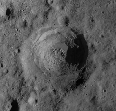
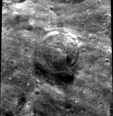
Right: Clementine
Images
LPOD Photo Gallery Lunar Orbiter Images Apollo Images
The peculiar "amphi-theatre" shaped Harriot was captured near the lower part of the right margin of Apollo 16's Fairchild-camera frame AS16-M-3001, which was made during TEC (Trans Earth Coast).
Research: Danny Caes
It should be mentioned: investigating this (rather unknown) part of the lunar farside with help of P.Spudis's and B.Bussey's Clementine Atlas of the Moon (LAC 30, page 61) is quite an adventure! - DannyCaes Nov 5, 2012
Maps
(LAC zone 30D3) USGS Digital Atlas PDF
Description
Wikipedia
Additional Information
- IAU page: Harriot
- There is a large amount of literature related to Harriot - some of the principal references are listed to Allan Chapman in the Bibliography section below.
- Harriot's lunar observations had been mentioned as early as 1784/1785 by Baron Zach. A more extensive account of Harriot's papers, including an explanation of Zach's involvement, appeared in Rigaud's Supplement:
Nomenclature
- Named for Thomas Harriot (1560-1621), a British mathematician and astronomer. Harriot is generally credited with having made the oldest surviving sketches of an astronomical object -- in this case the Moon -- as seen through a telescope.
- Three of his original drawings were on display at an exhibit honoring 400 years of the telescope.
- His observations were made from Syon House, near Kew Gardens, in London. His earliest drawing is dated July 26, 1609 on the Julian calendar then in use in England, or August 5, 1609 on the modern Gregorian calendar, at 9 hours after noon. The later drawings include a numbered and lettered full disk map, but it is not known if Harriot applied names to the numbered or lettered features. Whitaker (p. 57) mentions a 14 Dec 1611 reference (in Harriot's papers) to this map, so it was evidently completed sometime before that date. Whitaker (pp. 7 and 17) believes the only names Harriot associated with lunar surface features were pre-existing traditional ones based on naked eye observation.
- An excellent copy of Harriot's first sketch can be found here. The "6/1" notation in the lower right refers to the magnification produced by his telescope. For comparison, here is a digital simulation of how the Moon would have looked at that hour, created using the LOLA altimeter data shaded with the Clementine intensities. The simulation shows the Moon as seen from Syon House, but has been rotated 90° CCW to correspond more closely to the drawing.
Lettered craters

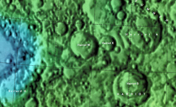
Color-coded LAC No. 30. Excerpt from the USGS Digital Atlas of the Moon.
LPOD Articles
Bibliography
- Burt, Geoff. 2009. Thomas Harriot's Drawings
- Chapman, Allan. 2009. Thomas Harriot, 1560 - 1621
- Chapman, Allan. 2009. A new perceived reality: Thomas Harriot's Moon maps. Astronomy & Geophysics, Volume 50, Issue 1, pp. 1.27-1.33. (PDF)
- Chapman, A. 2008. Thomas Harriot: the first telescopic astronomer. Journal of the British Astronomical Association, vol.118, no.6, pp. 315-325.
- Helden, Albert van. 1995/2003. Thomas Harriot (1560-1621)
- Strout, E. 1964/5. The Very First Maps and Drawings of the Moon. Journal of the British Astronomical Association 75, pp. 100-105.
- Bradley, James, Thomas Harriot, and Stephen Peter Rigaud. 1833. Supplement to Dr. Bradley's Miscellaneous works; with an account of Harriot's astronomical papers. Oxford: University Press.
Named Features -- Prev: Harpalus -- Next: Hartmann


