Difference between revisions of "Hadley Rille"
(Created page with "<div id="content_view" class="wiki" style="display: block"> =Hadley Rille= ''(informal name; [/IAU IAU] name: '''Rima Hadley''')''<br /> {| class="wiki_table" | Lat: 25....") |
|||
| Line 43: | Line 43: | ||
<br /> | <br /> | ||
==LPOD Articles== | ==LPOD Articles== | ||
| − | [http:// | + | [http://www2.lpod.org/wiki/December_24,_2006 Measuring a Serpent] [http://www2.lpod.org/wiki/February_26,_2004 On the Moon with Apollo 15] [http://www2.lpod.org/wiki/March_13,_2006 Amazing Pan] [http://www2.lpod.org/wiki/August_26,_2007 A Faulty Story] [http://www2.lpod.org/wiki/October_8,_2007 Slithering and Sliding]<br /> <br /> |
==APOD Articles== | ==APOD Articles== | ||
[http://apod.nasa.gov/apod/ap160805.html Part of Rima Hadley, seen in APOLLO 15's panorama made at Station 2 on the flank of Mount Hadley Delta] (CDR David Scott inspecting the Station 2 Boulder).<br /> <br /> | [http://apod.nasa.gov/apod/ap160805.html Part of Rima Hadley, seen in APOLLO 15's panorama made at Station 2 on the flank of Mount Hadley Delta] (CDR David Scott inspecting the Station 2 Boulder).<br /> <br /> | ||
Revision as of 20:15, 11 April 2018
Contents
Hadley Rille
(informal name; [/IAU IAU] name: Rima Hadley)
|
Lat: 25.0°N, Long: 3.0°E, Length: 80 km, Depth: 0.4 km, [/R%C3%BCkl%2022 Rükl: 22] |
Table of Contents
[#Hadley Rille Hadley Rille]
[#Hadley Rille-Images Images]
[#Hadley Rille-Maps Maps]
[#Hadley Rille-Description Description]
[#Hadley Rille-Description: Wikipedia Description: Wikipedia]
[#Hadley Rille-Additional Information Additional Information]
[#Hadley Rille-Nomenclature Nomenclature]
[#Hadley Rille-LPOD Articles LPOD Articles]
[#Hadley Rille-APOD Articles APOD Articles]
[#Hadley Rille-Lunar 100 Lunar 100]
[#Hadley Rille-Bibliography Bibliography]

Mick Hyde
Images
LPOD Photo Gallery Lunar Orbiter Images Apollo Images SMART-1
- Two assembled orbital Hasselblad photographs of Rima Hadley are included in the book [/Light%2C%201999 Full Moon] by Michael Light and Andrew Chaikin (plate 34). These photographs are AS15-81-10892 and 10894. Research: - DannyCaes DannyCaes Jan 1, 2008
- Lunar Orbiter 5's Frame 105 is one of its vertical close-ups of Rima Hadley and environs.
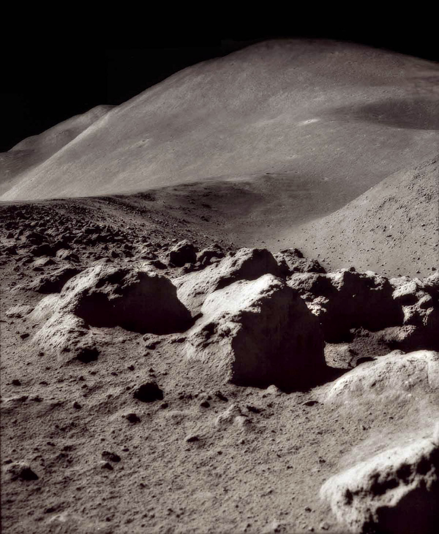
- Rocks and boulders on Rima Hadley's floor and slopes are seen in AS15-84-11287. This 500 mm Hasselblad was also included in the book [/Light%2C%201999 Full Moon] (plate 73).
- Mike Constantine's assembled panorama shows Rima Hadley and Hill 305 as seen from Station 2 (central) with Bennett Hill behind the Lunar Roving Vehicle, [/Mons%20Hadley%20Delta Mount Hadley Delta] at left, and [/Mons%20Hadley Mount Hadley] + the Swann Range at right.
- René Cantin has created a high-resolution, seamless portion of Jim Irwin's Station 10 pan showing a view of Rima Hadley from South, thru West, and around to the North ( 2.3 Mb ). Source: Eric M. Jones' Apollo Lunar Surface Journal (ALSJ).
- Don Davis' colorized version of a bend in Rima Hadley, with nearby boulders, made from black-and-white Hasselblad photographs which, according to Davis, are some of the best lunar landscape images ever photographed.
Maps
([/LAC%20zone LAC zone] 41B4) LAC map Geologic map LM map LTO map
USGS Geologic Map of Part of the Apennine-Hadley Region (I-723 2) (the Rima Hadley section northwest, west, and southwest of Apollo 15's landing site).
Description
Description: Wikipedia
Additional Information
- Depth data from [/Kurt%20Fisher%20crater%20depths Kurt Fisher database]
- Viscardy, 1985: 0.4 km
- The rille is a thermal anomaly feature due to exposure of fresh rocks on its walls - [/Moore%20et%20al%2C%201980 Moore et al, 1980]
- Length at least 135 km, ave width ~ 1.2 and ave depth ~370 m (from Greeley (1971) quoted in F. Leverington, 2008).
- See [/Apollo%2015%20site Apollo 15 site] for other features visited by those astronauts.
- In 1962, the astronomer George Herbig seems to have created one of the best photographs of the Rima Hadley region, made through the 3-m reflecting telescope at Lick Observatory. This photograph was the source of NASA's plans to land humans on the 'plain' between Mt Hadley and Mt Hadley Delta, both near Rima Hadley (Apollo 15 landed there in the summer of 1971). George Herbig's target was not the moon, but... he had to wait until moonset to take photographs of deepsky objects (while waiting, he made 'THE' photograph of Rima Hadley!).
- Source: To a Rocky Moon; a Geologist's History of Lunar Exploration, Don E. Wilhelms, page 266.- DannyCaes DannyCaes May 16, 2014
- George Herbig: http://en.wikipedia.org/wiki/George_Herbig
Nomenclature
- Named after the nearby peak, [/Mons%20Hadley Mons Hadley].
- Number 112 in Debra Hurwitz's Atlas and Catalog of Sinuous Rilles.
- Rima Hadley was not part of the original [/IAU%20Nomenclature IAU Nomenclature]. The name was introduced on Sheet D3 of the [/System%20of%20Lunar%20Craters System of Lunar Craters] maps. Despite the usage popularized by Apollo 15, this feature does not ever appear to have been officially called Hadley Rille. - JimMosher JimMosher
- In his informal 1953 tour of [/Mare%20Imbrium Mare Imbrium], [/Copeland%2C%201953 Leland Copeland] referred to the two hills west of the Hadley rille's northern part as the Gateway Rocks. These were later informally called Hill 305 and Bennett hill by Apollo 15's crew and NASA personnel. The region has also been referred to as the [/Fresnel%20Ridge Fresnel Ridge]. D.Caes research.
LPOD Articles
Measuring a Serpent On the Moon with Apollo 15 Amazing Pan A Faulty Story Slithering and Sliding
APOD Articles
Part of Rima Hadley, seen in APOLLO 15's panorama made at Station 2 on the flank of Mount Hadley Delta (CDR David Scott inspecting the Station 2 Boulder).
Lunar 100
[/Lunar%20100 L66]: Lava channel near Apollo 15 landing site.
Bibliography
- APOLLO OVER THE MOON; A VIEW FROM ORBIT, Chapter 6: Rimae (Part 2: Sinuous Rimae, continued), Figures 202, 203, 204, 205, and 206.
- Greeley, Ronald. 1971. Lunar Hadley Rille: Considerations of Its Origin. Science, Volume 172, Issue 3984, pp. 722-725.
- Howard, Keith A.; Head, James W.; Swann, Gordon A. 1972. Geology of Hadley Rille. Proceedings of the Lunar Science Conference, vol. 2, p.1.
- Spudis, P. D.; Swann, G. A.; Greeley, R. 1988. The formation of Hadley Rille and implications for the geology of the Apollo 15 region. in Lunar and Planetary Science Conference, 18th, Houston, TX, Mar. 16-20, 1987, p. 243-254.
This page has been edited 1 times. The last modification was made by - tychocrater tychocrater on Jun 13, 2009 3:24 pm - afx2