Difference between revisions of "Engel'gardt (Engelhardt)"
| Line 4: | Line 4: | ||
{| class="wiki_table" | {| class="wiki_table" | ||
| | | | ||
| − | [http://www.lpod.org/coppermine/albums/userpics/Engelgardt_LO-V-030H_LTVT.jpg [[Image: | + | [http://www.lpod.org/coppermine/albums/userpics/Engelgardt_LO-V-030H_LTVT.jpg [[Image:Normal_Engelgardt_LO-V-030H_LTVT.jpg|external image normal_Engelgardt_LO-V-030H_LTVT.jpg]]]<br /> |
| | | | ||
| − | [http://lpod.org/coppermine/displayimage.php?pid=4596&fullsize=1 [[Image: | + | [http://lpod.org/coppermine/displayimage.php?pid=4596&fullsize=1 [[Image:Normal_engelgardt-large.jpg|external image normal_engelgardt-large.jpg]]]<br /> |
| | | | ||
| − | [[Image: | + | [[Image:Engelgardt-color.jpg|engelgardt-color.jpg]]<br /> |
|} | |} | ||
'''Left:''' ''[http://lpod.org/coppermine/displayimage.php?pos=-4339 Lunar Orbiter V-030H]'' '''Engel'gardt''' is in the center with a part of '''Engel'gardt B''' visible in the upper right. The highest point on the Moon detected by the Kaguya laser altimeter is on the rim between the two. '''Middle:''' [http://www.mapaplanet.org/explorer-bin/explorer.cgi?map=Moon&layers=moon_clementine_bw&info=NO&advoption=NO&sizeSelector=imageSize&lines=1372&samples=2604&Resolution=72.0132743362832&r=1&g=1&b=1&projection=SIMP&grid=none&stretch=auto&north=-0.08&south=9.44&west=191.77&east=209.85¢er_lat=0¢er=200.81&defaultcenter=on Clementine]. '''Right:''' [http://planetarynames.wr.usgs.gov/images/Lunar/lac_69.pdf Color-coded topography LAC 69] image from [[USGS%20Digital%20Atlas|USGS Digital Atlas]].<br /> <div id="toc"> | '''Left:''' ''[http://lpod.org/coppermine/displayimage.php?pos=-4339 Lunar Orbiter V-030H]'' '''Engel'gardt''' is in the center with a part of '''Engel'gardt B''' visible in the upper right. The highest point on the Moon detected by the Kaguya laser altimeter is on the rim between the two. '''Middle:''' [http://www.mapaplanet.org/explorer-bin/explorer.cgi?map=Moon&layers=moon_clementine_bw&info=NO&advoption=NO&sizeSelector=imageSize&lines=1372&samples=2604&Resolution=72.0132743362832&r=1&g=1&b=1&projection=SIMP&grid=none&stretch=auto&north=-0.08&south=9.44&west=191.77&east=209.85¢er_lat=0¢er=200.81&defaultcenter=on Clementine]. '''Right:''' [http://planetarynames.wr.usgs.gov/images/Lunar/lac_69.pdf Color-coded topography LAC 69] image from [[USGS%20Digital%20Atlas|USGS Digital Atlas]].<br /> <div id="toc"> | ||
| Line 27: | Line 27: | ||
* IAU page: [http://planetarynames.wr.usgs.gov/Feature/1801 Engel'gardt (Engelhardt)] | * IAU page: [http://planetarynames.wr.usgs.gov/Feature/1801 Engel'gardt (Engelhardt)] | ||
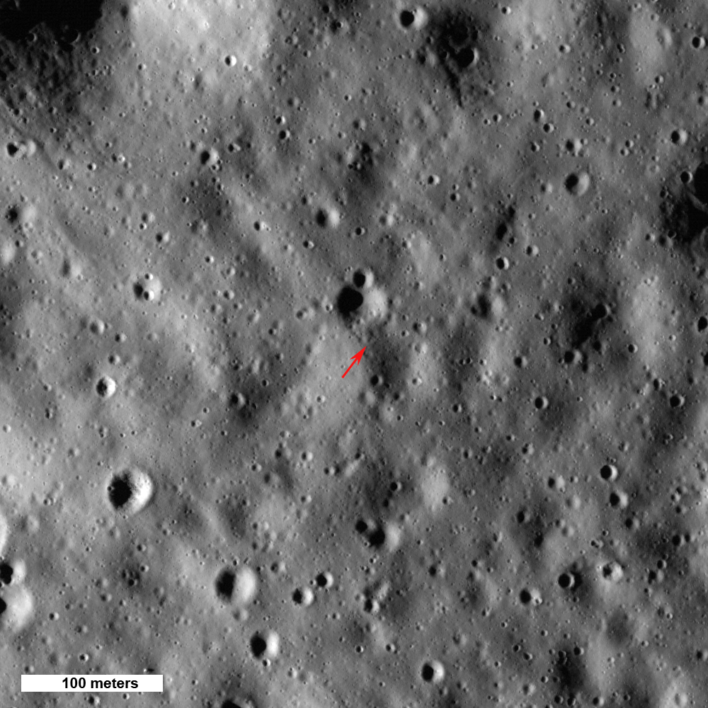
* According to the [[Kaguya|Kaguya]] laser altimeter, the [http://ltvt.wikispaces.com/Additional%20Textures#High-Low highest point] on the Moon is on the shared rim of '''Engel'gardt''' and '''Engel'gardt B'''. This point is on the primary rim of the [[Dirichlet-Jackson%20Basin|Dirichlet-Jackson Basin]]. The lowest point is on the floor of the farside crater [[Antoniadi|Antoniadi]]. | * According to the [[Kaguya|Kaguya]] laser altimeter, the [http://ltvt.wikispaces.com/Additional%20Textures#High-Low highest point] on the Moon is on the shared rim of '''Engel'gardt''' and '''Engel'gardt B'''. This point is on the primary rim of the [[Dirichlet-Jackson%20Basin|Dirichlet-Jackson Basin]]. The lowest point is on the floor of the farside crater [[Antoniadi|Antoniadi]]. | ||
| − | * Image below shows a [[LROC|LROC]] view of the [http://lroc.sese.asu.edu/news/?archives/302-Highest-Point-on-the-Moon!.html highest point] on the Moon.<br /> [http://lroc.sese.asu.edu/news/uploads/hpoint_lowsun.png [[Image: | + | * Image below shows a [[LROC|LROC]] view of the [http://lroc.sese.asu.edu/news/?archives/302-Highest-Point-on-the-Moon!.html highest point] on the Moon.<br /> [http://lroc.sese.asu.edu/news/uploads/hpoint_lowsun.png [[Image:Highest-point.jpg|highest-point.jpg]]]''click for larger view.'' |
<br /> | <br /> | ||
==Nomenclature== | ==Nomenclature== | ||
| Line 37: | Line 37: | ||
<br /> | <br /> | ||
==Lettered Craters== | ==Lettered Craters== | ||
| − | [[Image: | + | [[Image:Engelgardt-letter.jpg|engelgardt-letter.jpg]]<br /> Excerpt from the ''[http://planetarynames.wr.usgs.gov/dAtlas.html USGS Digital Atlas of the Moon].''<br /> <br /> |
==LPOD Articles== | ==LPOD Articles== | ||
<br /> | <br /> | ||
Latest revision as of 02:48, 16 April 2018
Contents
Engel'gardt (Engelhardt)
(current IAU name; originally Engelhardt)
Lat: 5.7°N, Long: 159.0°W, Diam: 43 km, Depth: km, Rükl: (farside)
|
|


Images
LPOD Photo Gallery Lunar Orbiter Images Apollo Images
- Engel'gardt is also visible near the right margin of frame AS11-42-6274.
- Additional research Apollo 11 orbital photography: Danny Caes
Maps
(LAC zone 69C1) USGS Digital Atlas PDF
Description
Wikipedia
Additional Information
- IAU page: Engel'gardt (Engelhardt)
- According to the Kaguya laser altimeter, the highest point on the Moon is on the shared rim of Engel'gardt and Engel'gardt B. This point is on the primary rim of the Dirichlet-Jackson Basin. The lowest point is on the floor of the farside crater Antoniadi.
- Image below shows a LROC view of the highest point on the Moon.
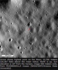 click for larger view.

Nomenclature
- Named for Vasilij Pavlovich Engel'gardt (1828-1915), a Russian astronomer.
- Engelhardt was in the list of IAU-approved farside names published in Menzel, 1971. The biographical information, supplied there by Prof. B. Levin, describes the honoree as a "Russian amateur astronomer [who] made numerous observations of comets, asteroids, nebulae, and star clusters from his private observatory in Dresden." Baron von Engelhardt (as he was known in Germany) published at least one book describing his astronomical observations.
- The IAU approved spelling was changed to Engel'gardt at some unknown later date. As with several other names of this sort, since the change was not documented it is unclear if the old spelling in parenthesis is regarded as part of the current official IAU name, or not.
- According to this map (1969) of the Sternberg Institute, there should be a crater east-northeast of Engel'gardt for which the name Wheatstone was proposed (lunar formation N° 747 in the accompanying nomenclature gazetteer). Slightly north of the above mentioned Wheatstone, there should be a crater for which the name Perevoshchikov was suggested (N° 587 on the same map). Neither of these names was adopted by the IAU. Research: Danny Caes
Lettered Craters

Excerpt from the USGS Digital Atlas of the Moon.
LPOD Articles
LRO Articles
Bibliography
- An Obituary notice for "B. P. Engelhardt" appears in JBAA, vol. 26, p. 39 (1915).
- According to the curator of the above-referenced site, noted astronomical historian Wolfgang Dick, "Basilius von Engelhardt" would be the German form of the Russian name "Vasily [or Vasilij] Engelgardt" which might explain the initials "B. P." Prof. Dick reports that Engelhardt was born in Russia and died Dresden and believes his ancestors were of German, rather than Russian, origin.
Named Features -- Prev: Endymion -- Next: Eötvös