Difference between revisions of "Capuanus"
| Line 3: | Line 3: | ||
{| class="wiki_table" | {| class="wiki_table" | ||
| | | | ||
| − | Lat: 34.1°S, Long: 26.7°W, Diam: 59 km, Depth: 1.6 km, [ | + | Lat: 34.1°S, Long: 26.7°W, Diam: 59 km, Depth: 1.6 km, [[R%C3%BCkl%2063|Rükl: 63]]<br /> |
|} | |} | ||
<div id="toc"> | <div id="toc"> | ||
| Line 11: | Line 11: | ||
[http://www.lpod.org/coppermine/thumbnails.php?album=search&type=full&search=Capuanus LPOD Photo Gallery] [http://www.lpi.usra.edu/resources/lunar_orbiter/bin/srch_nam.shtml?Capuanus%7C0 Lunar Orbiter Images] [http://www.lpi.usra.edu/resources/apollo/search/feature/?feature=Capuanus Apollo Images]<br /> <br /> | [http://www.lpod.org/coppermine/thumbnails.php?album=search&type=full&search=Capuanus LPOD Photo Gallery] [http://www.lpi.usra.edu/resources/lunar_orbiter/bin/srch_nam.shtml?Capuanus%7C0 Lunar Orbiter Images] [http://www.lpi.usra.edu/resources/apollo/search/feature/?feature=Capuanus Apollo Images]<br /> <br /> | ||
==Maps== | ==Maps== | ||
| − | ''([ | + | ''([[LAC%20zone|LAC zone]] 111A2)'' [http://www.lpi.usra.edu/resources/mapcatalog/LAC/lac111/ LAC map] [http://www.lpi.usra.edu/resources/mapcatalog/usgs/I824/ Geologic map]<br /> <br /> |
==Description== | ==Description== | ||
<br /> | <br /> | ||
==Description: Elger== | ==Description: Elger== | ||
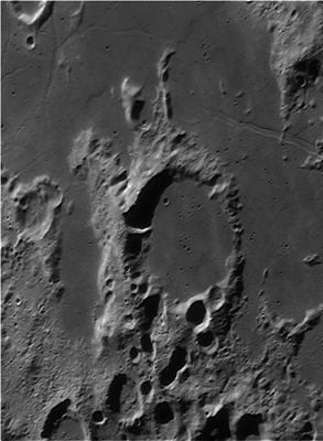
| − | ''([ | + | ''([[IAU%20Directions|IAU Directions]])'' CAPUANUS.--A large ring-plain, about 34 miles in diameter, W. of [[Cichus|Cichus]], with a border especially remarkable on the W., where it rises more than 8,000 feet above the outside country, and includes a large brilliant shallow crater. It is broken on the N.E. by a small but noteworthy double crater; and on the S. its continuity is destroyed for many miles by a number of big circular and sub-circular depressions and prominent deep valleys, far too numerous and complicated to describe. The level dusky interior contains only a low mound on the S., but is crossed by some light streaks running from N. to S.<br /> <br /> |
==Description: Wikipedia== | ==Description: Wikipedia== | ||
[http://en.wikipedia.org/wiki/Capuanus_(crater) Capuanus]<br /> <br /> | [http://en.wikipedia.org/wiki/Capuanus_(crater) Capuanus]<br /> <br /> | ||
==Additional Information== | ==Additional Information== | ||
| − | Depth data from [ | + | Depth data from [[Kurt%20Fisher%20crater%20depths|Kurt Fisher database]]<br /> |
* Pike, 1976: 1.6 km | * Pike, 1976: 1.6 km | ||
* Westfall, 2000: 1.6 km | * Westfall, 2000: 1.6 km | ||
* Cherrington, 1969: 1.88 km | * Cherrington, 1969: 1.88 km | ||
| − | * Satellite crater Capuanus L is on the [ | + | * Satellite crater Capuanus L is on the [[ALPO%20list%20of%20banded%20craters|ALPO list of banded craters]] |
<br /> | <br /> | ||
==Nomenclature== | ==Nomenclature== | ||
Revision as of 15:42, 15 April 2018
Contents
Capuanus
|
Lat: 34.1°S, Long: 26.7°W, Diam: 59 km, Depth: 1.6 km, Rükl: 63 |
Table of Contents

Wes Higgins
Images
LPOD Photo Gallery Lunar Orbiter Images Apollo Images
Maps
(LAC zone 111A2) LAC map Geologic map
Description
Description: Elger
(IAU Directions) CAPUANUS.--A large ring-plain, about 34 miles in diameter, W. of Cichus, with a border especially remarkable on the W., where it rises more than 8,000 feet above the outside country, and includes a large brilliant shallow crater. It is broken on the N.E. by a small but noteworthy double crater; and on the S. its continuity is destroyed for many miles by a number of big circular and sub-circular depressions and prominent deep valleys, far too numerous and complicated to describe. The level dusky interior contains only a low mound on the S., but is crossed by some light streaks running from N. to S.
Description: Wikipedia
Additional Information
Depth data from Kurt Fisher database
- Pike, 1976: 1.6 km
- Westfall, 2000: 1.6 km
- Cherrington, 1969: 1.88 km
- Satellite crater Capuanus L is on the ALPO list of banded craters
Nomenclature
- Francesco Capuano Di Manfredonia; Italian astronomer (c. 1400-unkn).
- Crater Capuanus E was called Emley by Hugh Percy Wilkins and Patrick Moore, but the I.A.U. did not accept that name.
- Emley: contemporary English selenographer.
LPOD Articles
Bibliography
Capuanus E ("Emley"): THE MOON by H.P.Wilkins and P.Moore.
This page has been edited 1 times. The last modification was made by - tychocrater tychocrater on Jun 13, 2009 3:24 pm - afx3u2