Difference between revisions of "Bhabha"
| Line 19: | Line 19: | ||
''([[LAC%20zone|LAC zone]] 133A4)'' [http://planetarynames.wr.usgs.gov/images/Lunar/lac_133.pdf USGS Digital Atlas PDF]<br /> <br /> | ''([[LAC%20zone|LAC zone]] 133A4)'' [http://planetarynames.wr.usgs.gov/images/Lunar/lac_133.pdf USGS Digital Atlas PDF]<br /> <br /> | ||
==Description== | ==Description== | ||
| − | '''Bhabha''' lies close to the central regions of the [[South%20Pole-Aitken%20Basin|South Pole Aitken Basin (SPA-B)]] -- a 2500 kilometre-wide basin of the [[Stratigraphy|pre-Nectarian]] period (~ 4.6 to 3.92 bn years) whose centre is approximately at 54.2S, 168.7W. Aged as [[Stratigraphy|Nectarian]] (~ 3.92 to 3.85 bn years), the crater looks relatively fresh with sharp-looking terraced walls all around -- except for its eastern section where the rim has been altered by movement of material (or is it impact-related?). The floor is flat showing signs of a dark-ish material in the south-eastern portion, and the whole inner area is topped off with a series of cental peaks that open towards the north. <span class="membersnap">- | + | '''Bhabha''' lies close to the central regions of the [[South%20Pole-Aitken%20Basin|South Pole Aitken Basin (SPA-B)]] -- a 2500 kilometre-wide basin of the [[Stratigraphy|pre-Nectarian]] period (~ 4.6 to 3.92 bn years) whose centre is approximately at 54.2S, 168.7W. Aged as [[Stratigraphy|Nectarian]] (~ 3.92 to 3.85 bn years), the crater looks relatively fresh with sharp-looking terraced walls all around -- except for its eastern section where the rim has been altered by movement of material (or is it impact-related?). The floor is flat showing signs of a dark-ish material in the south-eastern portion, and the whole inner area is topped off with a series of cental peaks that open towards the north. <span class="membersnap">- JohnMoore2</span><br /> <br /> |
==Description: Wikipedia== | ==Description: Wikipedia== | ||
[http://en.wikipedia.org/wiki/Bhabha_(crater) Bhabha]<br /> <br /> | [http://en.wikipedia.org/wiki/Bhabha_(crater) Bhabha]<br /> <br /> | ||
Latest revision as of 21:02, 16 April 2018
Contents
Bhabha
| Lat: 55.1°S, Long: 164.5°W, Diam: 64 km, Depth: km, Rükl: (farside) | |
|
| |


Images
LPOD Photo Gallery Lunar Orbiter Images Apollo Images
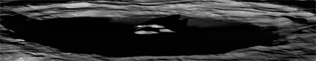
- A low-angle LROC view of Bhabha showing most of the crater's interior (other than the tops of the central peaks) in shadow.
- Zoomable version

Maps
(LAC zone 133A4) USGS Digital Atlas PDF
Description
Bhabha lies close to the central regions of the South Pole Aitken Basin (SPA-B) -- a 2500 kilometre-wide basin of the pre-Nectarian period (~ 4.6 to 3.92 bn years) whose centre is approximately at 54.2S, 168.7W. Aged as Nectarian (~ 3.92 to 3.85 bn years), the crater looks relatively fresh with sharp-looking terraced walls all around -- except for its eastern section where the rim has been altered by movement of material (or is it impact-related?). The floor is flat showing signs of a dark-ish material in the south-eastern portion, and the whole inner area is topped off with a series of cental peaks that open towards the north. - JohnMoore2
Description: Wikipedia
Additional Information
- Central peak composition: AGN, AN, GN & G (Tompkins & Pieters, 1999)
- Within SPA basin, less than 90% anorthosite in central peak, and 0.1 to 0.6 Maturity Index (not mature) Ohtake and others, 2009
- Ohtake and others, 2009 give a diameter of 78 km; the IAU value (above) differs.
Nomenclature
- Named for Homi Jehangir (1909-1966), an Indian physicist.
- This name was introduced into the IAU nomenclature in the long list of farside names published in Menzel, 1971.
LROC Articles
Bhabha sinks into the shadows.
LPOD Articles
Bibliography