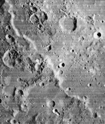
Rupes Altai
Contents
Rupes Altai
(current IAU name, formerly Altai Scarp and before that Altai Mts)
|
Lat: 24.3°S, Long: 22.6°E, Length: 427 km, Height: 1 km, Rükl: 57 |
Images
LPOD Photo Gallery Lunar Orbiter Images Apollo Images
- Rupes Altai was also captured on several frames made by the southward looking mapping/metric Fairchild camera of Apollo 16, such as frame AS16-M-0696, which shows the sunlit slopes of Rupes Altai's northern part between Catharina, Fermat, and Tacitus, this near the central part of the depicted curved horizon.
- Research: Danny Caes.
Maps
(LAC zone 96C1) LAC map Geologic map
Description
Description: Elger
(IAU Directions) THE ALTAI MOUNTAINS.--form a magnificent chain, 275 miles in length, commencing on the outer western slope of Piccolomini, and following a tolerably direct north-west course, with a few minor bendings, to the east side of Fermat, where they turn more towards the north, ultimately terminating about midway between Tacitus and Catherina. The region situated on the south-west is a great table-land, without any prominent features, rising gently towards the mountains, which shelve steeply down to an equally barren expanse on the north-east, to which they present a lofty face, having an average altitude of about 6,000 feet. The loftiest peak, over 13,000 feet, rises east of Fermat.
Description: Wikipedia
Additional Information
- Depth data from Kurt Fisher database
- Viscardy, 1985: 1 km
- Cherrington, 1969: 1.6 km
- Boint measured the vertical displacement at long. 25.625E, lat. 26.808S as 3050m. Boint, 2001.- fatastronomer
- Boint produced a profile of the Rupes Altai in Selenology Today 10, June, 2008. - fatastronomer
Nomenclature
- Named after the terrestrial Altai Mountains.
- In the original IAU nomenclature of Blagg and Müller this feature was known as the Altai (Mts.). Kuiper changed this to Altai Scarp with his "correction" being approved by the IAU in 1961. Three years later it was latinized to Rupes Altai in the System of Lunar Craters. - JimMosher
- It would be interesting to name one of the highest peaks in the lunar Altai mountains Gora Belukha (or Mount Belukha), because this is the highest peak in the terrestrial Altai range! Perhaps Polybius Beta? - DannyCaes Feb 23, 2008
- Polybius K, a curious crater between Polybius and the Rupes Altai, seems to be unofficially called Larrieu's Dam.
- Erroneously printed as RUPES ALTEAI (with "E") in the REVISED AND UPDATED EDITION of the Clementine Atlas of the Moon, 2012, CAMBRIDGE UNIVERSITY PRESS.- DannyCaes Jan 9, 2013
- It seems to be rather difficult to write the name ALTAI, because page 4 of the 21st Century Atlas of the Moon (2012) shows it as "ATLAI" (Atlai Scarp).- DannyCaes Jan 25, 2013
- Delvau-"X" is an unofficial name from Ron Delvaux for a rather large X-shaped appearance at Rupes Altai (see Ron Delvaux's website, or... Google Images). - DannyCaes Jun 2, 2016
Was Ken Mattingly's "LE ALDA" perhaps THE ALTAI?
154:02:57 G.E.T.: CMP Ken Mattingly (Apollo 16): "Okay. Maybe we could have drawn a terminator that was a little more over towards the area where we've shown our target, but there may be quite a drop-off in elevation here. It would only take - quite a bit, to the Sun angle wouldn't have to be an awful lot, on a geologic scale I guess. But the actual terminator was running down just to the west of Le Alda [or Mädler?] so I ran a strip down that".
- Apollo 16 Flight Journal, David Woods and Tim Brandt. Day 7: Lunar Orbital Observations, Revs 35 to 45
Additional research: Danny Caes (the "Le Alda" mystery).
LPOD Articles
Ring Around a Basin Ring Around the Piddle A Fault of Consequence Four Rings and a Mystery
Lunar 100
L7: Nectaris basin rim
Bibliography
Harold Hill. A Portfolio of Lunar Drawings, pages 200, 201.
