Montes Harbinger
Contents
- 1 Montes Harbinger
- 1.1 Images
- 1.2 Maps
- 1.3 Description
- 1.4 Description: Elger
- 1.5 Description: Wikipedia
- 1.6 Additional Information
- 1.7 The remains of an unnamed crater in the cluster of the Harbinger mountains?
- 1.8 Montes Harbinger's illuminated peaks before local sunrise
- 1.9 Nomenclature
- 1.10 Van Langren's nomenclature
- 1.11 The Aytona=Nachara / Silgero=Piperii mystery on the moonmap made by Langrenus
- 1.12 LPOD Articles
- 1.13 Bibliography
Montes Harbinger
(formerly Harbinger Mts)
|
Lat: 27.0°N, Long: 41.0°W, Diam: 90 km, Height: 2.5 km, Rükl: 19 |

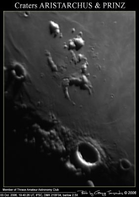
George Tarsoudis, Montes Harbinger consists of the brightly lit peaks near the top of this frame. At their southern end they touch the crescent ring of Prinz. The deeply shadowed crater near the left margin is Krieger, with Van Biesbroeck pitting its southern rim.
The large crater with the brightly-lit rim near the bottom is Aristarchus.
Images
LPOD Photo Gallery Lunar Orbiter Images Apollo Images
- Wonderful orbital close ups of Montes Harbinger were captured in 1971, thanks to Apollo 15's panoramic ITEK-camera: frames AS15-P-10310 and 10315 (western part of Montes Harbinger), frames 10308 and 10313 (eastern part of Montes Harbinger).
- Apollo 15's southward looking mapping/metric FAIRCHILD-camera frames AS15-M-2603, 2604, 2605, and 2606 show Montes Harbinger in the foreground, near the frame's upper margin.
- Apollo 15's HASSELBLAD-camera frame AS15-88-11978 shows Montes Harbinger near the upper margin, and Prinz above the lower right corner. A little bit of Aristarchus is visible in the lower right corner.
Research Danny Caes
Maps
(LAC zone 39A3) LAC map Geologic map LM map LTO map
Description
Description: Elger
(IAU Directions) THE HARBINGER MOUNTAINS.--A remarkable group of moderate height, mostly extending from the N.E. of Herodotus towards Aristarchus. They include a large incomplete walled-plain about 30 miles in diameter, defined on the E. by a lofty border, forming part of a mountain chain, and open to the south. This curious formation has many depressions in connection with its N.E. edge. On the N. of it there is a crater-row and a very peculiar zig-zag cleft. The region should be observed when the W. longitude of the morning terminator is about 45 deg.
Description: Wikipedia
Additional Information
Depth data from Kurt Fisher database
- Viscardy, 1985: 2.5 km
- Cherrington, 1969: 1.76 km
The remains of an unnamed crater in the cluster of the Harbinger mountains?
Chart SLC-E3 shows the remains of an unnamed crater about the same size as nearby Prinz. The location of this unnamed crater is west of Harbinger Beta and Harbinger Zeta, and east of the elongated hill north of Prinz (with the section Mu as its most northern part).
Montes Harbinger's illuminated peaks before local sunrise
Wonderful appearance of the two major sunlit peaks of Montes Harbinger during the evening of august the 13th, 2016, around 9:00 U.T. (sunrise terminator still eastward of both peaks), while Gassendi was in total darkness except its central peak and parts of the western section of its rim. Observed through an Orion-SkyQuest Dobsonian telescope from Ghent, East Flanders.
 - DannyCaes Aug 13, 2016
Nomenclature
Montes Harbinger is a name from William Radcliff Birt.
These mountains are the harbingers of dawn on crater Aristarchus west of them (always during Waxing Gibbous Moon).
According to Chart SLC-E3 (System of Lunar Craters), the peaks of the Harbinger mountains received 6 or perhaps 7 Greek letter designations.
From north to south:
- Harbinger Delta (the northern one of the two main Harbingers).
- Harbinger Zeta (slightly northwest of Harbinger Beta).
- Harbinger Beta (the southern one of the two main Harbingers).
- Harbinger Theta (southwest of Harbinger Beta).
- Harbinger Gamma (southwest of Harbinger Theta).
- Harbinger Alpha (or Prinz Alpha?) (immediately east of Prinz).
- A possible "addition" to the Harbingers could be the hill Mu at the northern part of the suspected small basin north-northeast of Prinz.
Van Langren's nomenclature
(source: E.A.Whitaker's Mapping and Naming the Moon)
 Harbinger Alpha was called Cuevio.
 Harbinger Beta was called Aytona.
 Harbinger Delta and Eta were called Silgero.
The Aytona=Nachara / Silgero=Piperii mystery on the moonmap made by Langrenus
What happened during the making of Michel Florent Van Langren's map? According to E.A.Whitaker, two sections of the system of mountains officially known as Montes Harbinger seem to have been moved to the northeast and were called Nachara and Piperii. At their "southwest" locations they were called Aytona and Silgero. Indeed, on Van Langren's map there are two couples of named formations. Couple 1 shows Aytona and Silgero, couple 2 shows Nachara and Piperii.
 - DannyCaes Jun 13, 2017
LPOD Articles
Dark Mare, Bright Rims. Aperture
Bibliography
A Portfolio of Lunar Drawings (Harold Hill), pages 74, 75.