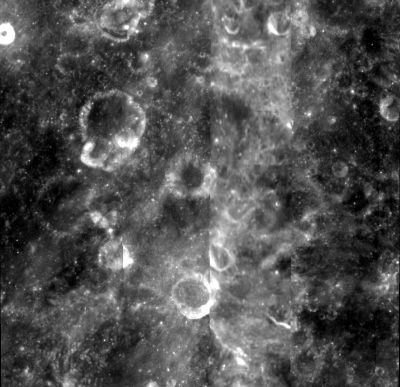
Lipskiy
Contents
Lipskiy
| Lat: 2.2°S, Long: 179.5°W, Diam: 80 km, Depth: km, Rükl: (farside) |
Images
LPOD Photo Gallery Lunar Orbiter Images Apollo Images
- Dept., of Lunar and Planetary Research, Moscow University, Russia (Note in this image link the authors have named it Lipsky).
- LOII-034-med is a Hi-Res scan of the photograph mentioned in the LPI's searchlist for Lunar Orbiter photographs of the Lipskiy region (in this Hi-Res scan, north is toward the bottom of the frame).
- Three of Apollo 11's orbital photographs of the moon's far side show a small region at the southern part of Lipskiy. These three photographs are mentioned in the LPI's searchlist DAEDALUS, NORTH OF. Research: Danny Caes
Maps
(LAC zone 86B1) USGS Digital Atlas PDF
IAU page
Description
Description: Wikipedia
Additional Information
- Lipskiy is the named feature closest to the exact center of the Moon's farside.
Nomenclature
- Named for Yurii Naumovich Lipskiy (1909-1978), a Soviet selenographer. As founder of the Department of Lunar and Planetary Physics of the Sternberg Institute at Moscow State University, he was, in 1959, one of the first to interpret images of the Moon's farside.
- The name was approved in IAU Transactions XVIIB (1979). Its placement presumably honors Lipskiy's pioneering work on the farside.
- Strange to say, Lipskiy's name is absent on the revised edition of the National Geographic Society's map THE EARTH'S MOON (revised in 2003, reprinted in 2014). - DannyCaes Oct 7, 2015
LPOD Articles
Bibliography
