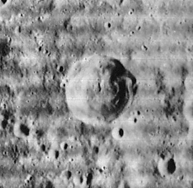
Tacitus
Contents
Tacitus
|
Lat: 16.2°S, Long: 19.0°E, Diam: 39 km, Depth: 2.84 km, [/R%C3%BCkl%2057 Rükl: 57] |
Table of Contents

LOIV 089 H2
Images
LPOD Photo Gallery Lunar Orbiter Images Apollo Images
- Tacitus was also captured on several frames made by the southward looking mapping/metric Fairchild camera of Apollo 16, such as in frame AS16-M-0697, which shows the pronounced crater Tacitus slightly "above" the centre of the line which connects the frame's centre and the centre of the frame's left margin.
- Research: Danny Caes.
Maps
([/LAC%20zone LAC zone] 96A2) LAC map Geologic map
Description
Description: Elger
([/IAU%20Directions IAU Directions]) TACITUS.--A bright ring-plain, about 28 miles in diameter, a few miles W. of [/Catharina Catherina], with a lofty wall rising both on the W. and E. to more than 11,000 feet above the floor. Its continuity is broken on the N. by a gap occupied by a depression, and there is a conspicuous crater below the crest on the S.E. The central mountain is connected with the N. wall by a ridge, recalling the same arrangement within [/M%C3%A4dler Mädler]. A range of lofty hills, an offshoot of the [/Rupes%20Altai Altai range], extends from Tacitus towards [/Fermat Fermat].
Description: Wikipedia
Additional Information
- Depth data from [/Kurt%20Fisher%20crater%20depths Kurt Fisher database]
- Westfall, 2000: 2.84 km
- Viscardy, 1985: 2.84 km
- Cherrington, 1969: 2.83 km
- Central peak height
- [/Sekiguchi%2C%201972 Sekiguchi, 1972]: 0.5 km "Very long dyke parallel to the meridian line" - fatastronomer fatastronomer
- Tacitus D central peak height
- [/Sekiguchi%2C%201972 Sekiguchi, 1972]: 0.5 km "A mountain having a summit crater" - fatastronomer fatastronomer
- A bright "half ejectablanket" at 17°35' South/ 19°15' East (immediately south of Tacitus) is noticeable during the days before, during, and after Full Moon. This ejectablanket looks like some sort of bright "arc". See LROC close-up: http://bit.ly/2ChElPC- DannyCaes DannyCaes Jan 18, 2009
Nomenclature
- According to the [/IAU%20Planetary%20Gazetteer IAU Planetary Gazetteer], this feature is named for Cornelius Tacitus (ca. 56 – ca. 117), a senator and historian of the Roman Empire.
- As noted by Kuiper in [/PLA%20Table%20III Table III] of his [/Photographic%20Lunar%20Atlas Photographic Lunar Atlas], the present name is actually a misspelling by [/Beer%20and%20M%C3%A4dler Beer and Mädler] of the name Tatius given by [/Riccioli Riccioli]. Riccioli had in mind a certain Achilles Tatius of the 4th century A.D., who he describes in his Chronology as a Bishop of Alexandria.
- This feature is Catalog number 3759 in Mary Blagg's [/Collated%20List Collated List], where the spelling Tacitus was used by all three authorities, and was adopted in that form in the original IAU nomenclature of [/Named%20Lunar%20Formations Named Lunar Formations].
- Kuiper observed it would be too confusing to "correct" the spelling.
LPOD Articles
Bibliography
This page has been edited 1 times. The last modification was made by - tychocrater tychocrater on Jun 13, 2009 3:24 pm - afx3u2